Maps of Lucerne

[Reliefkarte der Centralschweiz]
Imfeld, Xaver [Wurster, Randegger]
Reliefkarte der Centralschweiz
Imfeld, Xaver J. Wurster & Cie.
Argow cum parte merid. Zvrichgow
1 Karte : Kupferdruck ; 37 x 48 cm Mercator; Janssonius Joannes Janssonius
Argow cum parte merid. Zvrichgow
1 Karte : Kupferdruck ; 37 x 48 cm Mercator; Schenk; Valck apud G. Valk et P. Schenk
Argow cum parte merid. Zvrichgow
1 Karte : Kupferdruck ; 37 x 49 cm Blaeu; Mercator Willem Janszoon Blaeu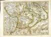
[Argow]
1 Karte : Kupferdruck ; 34 x 45 cm Mercator; Hondius Henricus Hondius
[Argow]
1 Karte : Kupferdruck ; 34 x 45 cm Mercator s.n.
<<Der>> Canton Luzern
1 : 270000 1 Karte gezeichnet v. Jost Pfyffer v. Altishofen ; gest. v. J. Scheurmann Orell Füssli & Comp., Züric [i.e. Zürich]
Le Theatre de Bellone :
Mollova mapová sbírka Schenk, Pieter Braakman, Adriaan
Kantone Uri, Schwyz und Unterwalden
1 : 1450000 [Stumme Kartenskizzen der ganzen Schweiz und der einzelnen Kantone zu Unterrichtszwecken] Schulbuchhandlung Antenen
Atlas der alten Eidgenossenschaft in 20 Karten: Kanton Uri
Originaltitel: Canton Uri sive Pagus Helvetiae Uriensis cum Subditis suis in Valle Lepontina. Mit Erklärung der Zeichen sowie Nebenkarte vom Livinental und Zeichnung des Wasserfalles im Schächental. Zeichnung: Walser, Gabriel (1695-1776), reformierter Pfarrer, von Teufen AR Herausgeber: Homännische Erben
<<Die>> Cantone Uri und Unterwalden
1 : 260000 1 Karte gestochen von J. Scheurmann Orell, Füssli & Cp., Zürich
Verbreitung d. Cretinismus, d. Blödsinns und d. Taubstummheit, 1841
1 : 260000 1 Karte [Orell, Füssli & Cp.], [Zürich]
Atlas novus Reipublicae Helveticae
1 Atlas ([40] Bl., 97 S.) bey Orell, Gessner und Compagnie, Zürich
<<Die>> Cantone Uri und Unterwalden
1 : 260000 1 Karte gestochen von J. Scheurmann Orell Füssli & Cp., Zürich
Atlas der Schweiz
1 : 450000 1 Atlas (18 Bl.) gez. u. gest. v. J. Scheurmann Orell Fussli, Zurich
<<Die>> Cantone Uri und Unterwalden
1 : 260000 1 Karte gestochen von J. Scheurmann [Orell Füssli & Comp.], [Zürich]
Atlas de la Suisse
1 : 450000 1 Atlas (19 Bl.) dessiné par MM. H. Keller, Scheurmann, Pfyffer d'Altishofen, Osterwald, etc. ; gravé par M. Scheurmann Orell Füssli & Co., Zürich
<<Der>> Canton Luzern
1 : 270000 1 Karte gezeichnet v. Hr. Jost Pfyffer v. Altishofen Oberstl. d. Artill. ; gest. v. J. Scheurmann Orell, Füssli & Comp. Libraires & Marchands d'Estampes, Züric [i.e. Zürich]
<<Die>> Cantone Uri und Unterwalden
1 : 260000 1 Karte gestochen von J. Scheurmann Orell Füssli & Cp., Zürich
Tugeni in Helvetiis
1 : 250000 Mollova mapová sbírka Sanson, Nicolas Liébaux, Jean-Baptiste Mariette, Pierre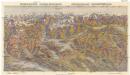
Zentralschweiz - Central Switzerland
Alpy švýcarské Erva
Relief pittoresque du sol classique de la Suisse
1 Vogelschaukarte auf 9 Bl. dessiné d'après nature et gravé à l'eau forte par Frédéric Guillaume Delkeskamp ; terminé à l'aqua tinta par François Hegi et J.J. Sperli à Zuric = [Malerisches Relief des klassischen Bodens der Schweiz] / [Nach der Natur gezeichnet und radirt von Friedrich Wilhelm Delkeskamp ; in Aqua tinta vollendet von Franz Hegi und J.J. Sperli in Zürich] [Friedrich Wilhelm Delkeskamp], [Frankfurt a/M.]
Atlas de la Suisse
1 : 450000 1 Atlas (19 Bl.) dessiné par MM. H. Keller, Scheurmann, Pfyffer d'Altishofen, Osterwald, etc. ; gravé par M. Scheurmann Orell Füssli & Co., Zürich
Atlas der Schweiz
1 : 450000 1 Atlas (18 Bl.) gez. u. gest. v. J. Scheurmann Orell Fussli, Zurich
<<Der>> Canton Luzern
1 : 270000 1 Karte gezeichnet v. Jost Pfyffer v. Altishofen ; gest. v. J. Scheurmann Orell Füssli, Züric [i.e. Zürich]
Partie du Canton de Lucerne d'Unterwalden d'Uri et Zurich le Canton Glarus Schweiz et Zug.
From Atlas Suisse. Levé et dessiné par J. H. Weiss aux fraix de J. R. Meyer á Aarau dans les années 1786 á 1802. Gravée par Guerin, Eichler, et Scheurmann.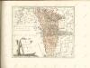

Karte der centralen Schweiz
1 : 200000 1 Karte von R. Leuzinger ; Schrift gestochen von P. Steiner bei Heinrich Fuessli u. Comp., Zürich
![[Reliefkarte der Centralschweiz]](https://images-2.georeferencer.com/images/iiif/843941165110/full/,300/0/native.jpg)

