Maps of Aargau

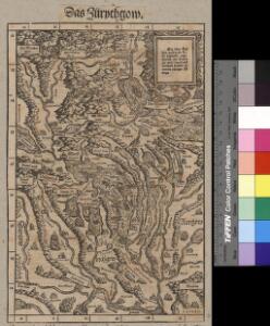
<<Das>> Zürychgow
1 : 400000 1 Karte [Johannes Stumpf]
Zürich
1 : 200000 1 Karte entworfen und bearbeitet von Woerl ; in Stein gestochen unter seiner Leitung 1834 ; Lithographie von B. Herder Herder, Freiburg im Breisgau
Original von Keller's zweiter Reisekarte der Schweiz
1 : 500000 1 Karte in 4 Teilen gest. v. J. Scheurmann Keller, Zürich
Zurichou [i.e. Zürichgau]
1 : 650000 1 Karte [von Jodocus Hondius] [excusum in aedibus Iudoci Hondij], [Amsterodami]
Zurichgow
1 : 1000000 1 Karte [sumptibus et typis aenis Iudoci Hondij], [Amsterodami]
Zurichou [i.e. Zürichgau]
1 : 600000 1 Karte [von Joannes Janssonius] [ex officina Ioannis Ianssonii], [Amsterodami]
Territorium der Republic Zürich
1 : 600000 1 Karte cura Ioh. Hofmeisteri
Landtaflen
1 Atlas [von Johannes Stumpf] Christoffel Froschower, Zürych
Territorium der Republic Zürich
1 : 600000 1 Karte cura Ioh. Hofmeisteri
<<Le>> canton de Zurich
1 : 600000 1 Karte
[Zurichgow, et Basiliensis provincia]
1 : 250000 1 Karte per Gerardum Mercatorem [sumptibus & typis aeneis Iudoci Hondij], [Amsterodami]
Territorium der Republic Zürich
1 : 600000 1 Karte cura Ioh. Hofmeisteri
Zurichgow et Basiliensis provincia
1 : 340000 1 Karte [sumptibus & typis aeneis Henrici Hondij], [Amsterodami]
Zürich Gebiet
1 : 250000 1 Karte J.H. Streulinus inv. ; J.G. Seiller sculpsit
Zvrichgow et Basiliensis provincia
1 Karte : Kupferdruck ; 37 x 48 cm Janssonius; Broeck apud Johannem Janssonium
Zvrichgow et Basiliensis provincia
1 Karte : Kupferdruck ; 37 x 48 cm Valck; Schenk; Broeck apud G. Valk et P. Schenk
Zvrichgow et Basiliensis provincia
1 Karte : Kupferdruck ; 37 x 48 cm Blaeu Willem Janszoon Blaeu
Zvrichgow et Basiliensis provincia
1 Karte : Kupferdruck ; 36 x 48 cm Mercator; Blaeu s.n.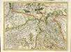
[Zurichgow, et Basiliensis provincia]
1 Karte : Kupferdruck ; 34 x 46 cm Mercator; Hondius Henricus Hondius
[Zurichgow, et Basiliensis provincia]
1 Karte : Kupferdruck ; 34 x 45 cm Mercator s.n.
[Zurichgow, et Basiliensis provincia]
1 : 250000 1 Karte per Gerardum Mercatorem [Mercator], [Duisburg]
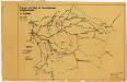
Eisenbahnprojecte der Central- und Ost-Schweiz
1 : 250000 Zürcher Ingenieur- und Architektenverein [s.n.]
Karte vom Canton Zürich 1795
1 : 600000 1 Karte M.P. f.
[Zurichgow, et Basiliensis provincia]
1 : 250000 1 Karte per Gerardum Mercatorem [Mercator], [Duisburg]
[Zurichgow, et Basiliensis provincia]
1 : 250000 1 Karte per Gerardum Mercatorem [sumptibus & typis aeneis Iudoci Hondij], [Amsterodami]
Zurichgow et Basiliensis provincia
1 : 300000 1 Karte [apud Iohannem et Cornelium Blaeu], [Amsterdam]
Neue und exacte geograph. Tabell von der Statt Zürich Gebiett
1 : 600000 1 Karte cura Ioh. Hofmeisteri ; Tobias Lobeck deli. et sculp.
[Zurichgow, et Basiliensis provincia]
1 : 250000 1 Karte per Gerardum Mercatorem [Hondius], [Amsterdam]
Schulwandkarte zur Geschichte der Schweiz
1 : 180000 1 Karte auf 6 Bl. bearbeitet v. W. Oechsli u. A. Baldamus ; gezeichnet von Ed. Gaebler Kartograph. Verlagsanstalt von Georg Lang, Leipzig