Maps of Bern

Tschudi's Touristenkarte der Centralschweiz
1 : 250000 1 Karte Stich u. Druck: Wurster, Randegger Scheitlin & Zollikofer, St. Gallen
<<Der>> Canton Luzern
1 : 270000 1 Karte gezeichnet v. Jost Pfyffer v. Altishofen ; gest. v. J. Scheurmann Orell Füssli & Comp., Züric [i.e. Zürich]
Kanton Bern
1 : 1450000 [Stumme Kartenskizzen der ganzen Schweiz und der einzelnen Kantone zu Unterrichtszwecken] Schulbuchhandlung Antenen
Per Inclyti Circuli Suevici Supremorum Ordinum :
1 : 160000 Mollova mapová sbírka Pfeffel, Johann Andreas Pfeffel, Johann Andreas I.
Zurichou [i.e. Zürichgau]
1 : 600000 1 Karte [von Joannes Janssonius] [ex officina Ioannis Ianssonii], [Amsterodami]
Zurichou [i.e. Zürichgau]
1 : 650000 1 Karte [von Jodocus Hondius] [excusum in aedibus Iudoci Hondij], [Amsterodami]
Zürich
1 : 200000 1 Karte entworfen und bearbeitet von Woerl ; in Stein gestochen unter seiner Leitung 1834 ; Lithographie von B. Herder Herder, Freiburg im Breisgau
Argow cum parte merid. Zurichgow [Karte], in: Novus Atlas, das ist, Weltbeschreibung, Bd. 1, S. 254.
1 Karte aus Atlas Blaeu, Joan Blaeu, Willem Janszoon
<<Der>> Canton Luzern
1 : 270000 1 Karte gezeichnet v. Hr. Jost Pfyffer v. Altishofen Oberstl. d. Artill. ; gest. v. J. Scheurmann Orell, Füssli & Comp. Libraires & Marchands d'Estampes, Züric [i.e. Zürich]

Argow cum parte merid. Zvrichgow
1 : 310000 Mollova mapová sbírka Mercator, Gerhard Schenk, Peter I
Argow cum parte merid. Zvrichgow
1 : 320000 Mollova mapová sbírka Mercator, Gerhard Blaeu, Joan I.
Zvrichgow et Basiliensis provincia
1 Karte : Kupferdruck ; 37 x 48 cm Janssonius; Broeck apud Johannem Janssonium
Zvrichgow et Basiliensis provincia
1 Karte : Kupferdruck ; 37 x 48 cm Valck; Schenk; Broeck apud G. Valk et P. Schenk
Zvrichgow et Basiliensis provincia
1 Karte : Kupferdruck ; 37 x 48 cm Blaeu Willem Janszoon Blaeu
Zvrichgow et Basiliensis provincia
1 Karte : Kupferdruck ; 36 x 48 cm Mercator; Blaeu s.n.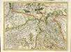
[Zurichgow, et Basiliensis provincia]
1 Karte : Kupferdruck ; 34 x 46 cm Mercator; Hondius Henricus Hondius
[Zurichgow, et Basiliensis provincia]
1 Karte : Kupferdruck ; 34 x 45 cm Mercator s.n.
Argow cum parte merid. Zurichgow [Karte], in: Theatrum orbis terrarum, sive, Atlas novus, Bd. 1, S. 297.
1 Karte aus Atlas Blaeu, Joan Blaeu, Willem Janszoon
[Argow] [Karte], in: Gerardi Mercatoris et I. Hondii Newer Atlas, oder, Grosses Weltbuch, Bd. 1, S. 265.
1 Karte aus Atlas Mercator, Gerhard und Hondius, Jodocus Jansson, Jan
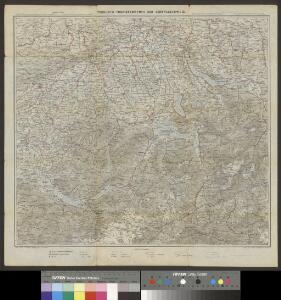
Militair Karte von Süd-Deutschland in 20 Sectionen
1 : 400000 17. Section Coulon, Alois von A. von Coulon
Argow cum parte merid. Zurichgow [Karte], in: Novus atlas absolutissimus, Bd. 4, S. 245.
1 Karte aus Atlas Janssonius Offizin
Argow cum parte merid. Zvrichgow
1 Karte : Kupferdruck ; 37 x 48 cm Mercator; Janssonius Joannes Janssonius
Argow cum parte merid. Zvrichgow
1 Karte : Kupferdruck ; 37 x 48 cm Mercator; Schenk; Valck apud G. Valk et P. Schenk
Argow cum parte merid. Zvrichgow
1 Karte : Kupferdruck ; 37 x 49 cm Blaeu; Mercator Willem Janszoon Blaeu
[Argow]
1 Karte : Kupferdruck ; 34 x 45 cm Mercator; Hondius Henricus Hondius
[Argow]
1 Karte : Kupferdruck ; 34 x 45 cm Mercator s.n.
ARGOW | cum parte merid. | ZVRICHGOW
Auctore Ger. Mercatore. [Amsterdam : Joan Blaeu]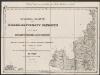
[Luzern, Zug, Uri, Schwyz, Unterwalden, Glarus, Teile Aargau und Zürich] [Karte], in: Gerardi Mercatoris Atlas, sive, Cosmographicae meditationes de fabrica mundi et fabricati figura, S. 270.
1 Karte aus Atlas Mercator, Gerhard Montanus, Petrus