Maps of Spain

Spanien und Portugal
Volksschul-Atlas über alle Teile der Erde Lange, Henry Druck und Verlag von Georg Westermann
Spanien und Portugal
1 : 2350000 Cádiz (Španělsko) Weiland, Karl Ferdinand im Verlage des Geographischen Instituts
Spanien und Portugal
1 : 2350000 Cádiz (Španělsko) Weiland, Karl Ferdinand im Verlage des Geographischen Instituts
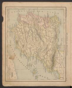
Spanien und Portugal
1 : 2280000 Portugalsko Weiland, Karl Ferdinand im Verlage des Geograph. Instituts
Spanien und Portugal
1 : 2260000 entworfen und gezeichnet von C. F. Weiland Weimar : Verlag des Geographischen Instituts
[Historisch-geographischer Atlas zu den allgemeinen Geschichtswerken von C. v. Rotteck, Pölitz u. Becker] : Spanien und Portugal zur Uebersicht der Hauptbegebenheiten dieser Reiche
von Julius Loewenberg Lithographie von B. Herder in Freiburg im Breisgau [Freiburg im Breisgau] : [Herder]

Spanien und Portugal
1 : 2300000 entworfen und gezeichnet von C. F. Weiland L.G. Jaeger sc. Weimar : Verlag des Geograph. Instituts
Carte des routes de postes et itinéraires d'Espagne et de Portugal
1 : 2440000 Portugalsko Lapie, Pierre Picquet, Ch. Artaria
Carte des routes de postes et itinéraires d'Espagne et de Portugal
1 : 2440000 Portugalsko Picquet, Ch. Lapie, Pierre Artaria
Spanien und Portugal
1 : 2350000 Cádiz (Španělsko) Weiland, Karl Ferdinand im Verlage des Geographischen Instituts
Spanien und Portugal
1 : 2350000 Cádiz (Španělsko) Weiland, Karl Ferdinand im Verlage des Geographischen Instituts
Carte des royaumes d'Espagne et de Portugal dans laquelle sont tracées les routes des postes
1 Karte : Kupferdruck ; 47 x 56 cm Robert de Vaugondy; Haussard s.n.
Typus Hispaniae ab Hesselo Gerardo delineata [...] [Karte], in: Novus atlas absolutissimus, Bd. 6, S. 15.
1 Karte aus Atlas Janssonius Offizin
The kingdoms of Spain & Portugal / compiled & reduced from numerous topographic surveys, the maritime survey of Don Vicente Tofino &c. ; London, publishd 1st Janury 1826 by Richard H. Laurie
1 Mapa, col. Ed. anglesa basada en obra de Tofiño Laurie, Richard H. Richard H. Laurie
Spanien und Portugal
1 : 2300000 entworfen und gezeichnet von C. F. Weiland L.G. Jaeger sc. Weimar : Verlag des Geograph. Instituts
Typus Hispaniae [Karte], in: Gerardi Mercatoris et I. Hondii Newer Atlas, oder, Grosses Weltbuch, Bd. 2, S. 168.
1 Karte aus Atlas Mercator, Gerhard und Hondius, Jodocus Jansson, Jan
Spanien und Portugal

Spain and Portugal.
1 : 3000000 Tanner, Henry S.
Carte d'Espagne et de Portugal
1 Karte auf 6 Blatt : Kupferdruck ; 73 x 82 cm Brion de la Tour; Jean chez Jean rue Jean de Beauvais. no. 10
Hispaniæ antiquæ tabula geographica
1 Karte : Kupferdruck ; 23 x 27 cm Delamarche; Delahaye s.n.
Španiely a Portugaly.

Espagne et Portugal
1 Karte : Kupferdruck ; 31 x 42 cm Mentelle; Tardieu Mentelle
Spanien und Portugal
Hand-Atlas über alle Theile der Erde nach dem neuesten Zustande und über das Weltgebäude Stieler, Adolf bei Justus Perthes
Espagne, Portugal.
1 : 3600000 Janvier, Jean
Espagne Ancienne ou Iberie.
1 : 3800000 Monin, C.V.
Espagne, Portugal.
1 : 2800000 Brue, Adrien Hubert, 1786-1832
Accuratissima totius regni Hispaniae Portugalliaeq[ue] tabula et typus novissimus
1 : 2370000 Portugalsko Wit, Frederick de x [officina Frederici de Witt