Maps of Polynesia

[Islas filipinas - pacifico]
Atlas de Filipinas Algué, P. José Government Printing Office
Asien
Allgemeiner Atlas [Walch, Johannes] im Verlag bei Johannes Walch
II. Charte für die allgemeine Geschichte von Troja’s Zerstörung bis auf den Anfang der Perserkriege : d.i. von 1184 bis 501 vor Christus
Entworfen von F.W. Benicken Weimar : im Verlage des L. Industrie-Comptoirs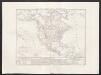
Carta generale dell'America settentrionale
1 : 25000000 Marzolla, Benedetto Real Litografia Militare
Asia
Hand-Atlas über alle Theile der Erde und über das Weltgebäude Stieler, Adolf Justus Perthes
The River systems of Asia & Europe
The physical atlas Johnston, Alexander Keith William Blackwood & Sons
[Recto], uit: Azië / aardrijksk. medew. G.J. de Vries
1 : 58000000 titelvariant: Landen van Azië met de hoofdsteden; Annotatie: Titel boven de kaart: Landen van Azië met de hoofdsteden Vries, Gerben Johannes de Sneek : Tonnema
Nieuwe kaart van het oostelykste deel der weereld, dienende tot aanwyzing van de scheepstogten der Nederlanderen naar Oostindië : volgens de laatste ontdekkingen
Te Amsterdam : by Is. Tirion
Asien
Plastischer Schul-Atlas über alle Theile der Erde : in 24 Karten Woldermann, G Verlag von P. Eckerlein
Asia
Stieler's Hand-Atlas Stieler, Adolf bei Justus Perthes
[Verbreitung der vorzüglicheren Säugethiere in der neuen Welt]
Zweiter Band, enthaltend in vier Abtheilungen die Vertheilung der Organismen: 5. Pflanzen-Geographie, 6. Thier-Geographie, 7. Anthropographie, 8. Ethnographie Humboldt, Alexander von Verlag von Justus Perthes
N. Hemisphere, plane of London.
1 : 41000000 Thomson, John
Schlegel's Versuch Einer Schlangen-Karte.
1 : 165000000 Berghaus, Heinrich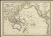
Carte de l'Océanie comprenant l'Australie, la Polynésie et du Grand Archipel d'Asie
1 : 37000000 dressée par Hérisson, géographe gravé par J. B. Tardieu ; Pelicier scrip. Paris : chez Jean, Rue St. Jean-de-Beauvais, No. 10
Vertheilung der Luftströmungen
země světa Gräf, C. Dellinger, A. Geographisches Institut
Asia secundum novas celeberrimi de l'Isle projectiones aliorumque recentissimorum geographorum observationes concinnata
1 : 22000000 cura et sumtibus M. Alb. et G. Fr. Lotter Aug. Vind : [Lotter]
[Zoological Geography, Geographical Division and Distribution of Reptilia (Reptiles)]
The physical atlas Johnston, Alexander Keith William Blackwood & Sons
Asia
Hand-Atlas über alle Theile der Erde nach dem neuesten Zustande und über das Weltgebäude Stieler, Adolf bei Justus Perthes
[Karte vom Grossen Ocean, Zur Übersicht der Strömungen, Temperatur und Handels-Strassen]
Erster Band, enthaltend in vier Abtheilungen die Erscheinungen der anorganischen Natur: 1. Meteorologie und Klimatographie. 2. Hydrologie und Hydrographie. 3. Geologie. 4. Tellurischer Magnetismus Humboldt, Alexander von Verlag von Justus Perthes
[Zoological Geography, Geographical Division & Distribution of Rodentia (Gnawing Animals)]
The physical atlas Johnston, Alexander Keith William Blackwood & Sons
IV. Charte für die allgemeine Geschichte von Augustus Alleinherrschaft bis auf den Untergang des weströmischen Reichs : d.i. von 30 v. Chr. bis 476 nach Christus
Entworfen von F.W. Benicken gez. von C.F. Weiland ; in Stein gravirt v. A. Falger Weimar : im Verlage des L. Industrie-Comptoirs
Die obere oder nordliche Halbkugel der Erde
1 Karte : Kupferdruck ; Durchmesser 41 cm Bode; Gürsch F. Nicolai
Hémisphère supérieur de la mappemonde
1 Karte : Kupferdruck ; Durchmesser 59 cm Chrysologue; Delahaye s.n.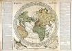
Horizon de Paris
1 Karte : Kupferdruck ; Durchmesser 48 cm, Bildgrösse 60 x 85 cm Durand; Desbruslins chez le Sr. Durand rüe St. Jacques à St. Landry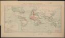
Carte des communications télégraphiques
1 : 70000000 Mager, Henri 1859-19..; L'Expansion française coloniale Paris : L'Expansion coloniale française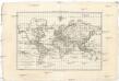
Carte générale de toutes les parties connues de la surface de la terre en carte réduite
země světa Bonne, Rigobert
Europe spheroidale.
1 : 41000000 Garnier, F. A., 1803-1863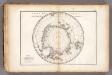
Carte des glaces australes.
1 : 42000000 Vincent
Westlicher Planiglob der Erde
1 : 17000000 Weimar : Verlag des Geographischen Instituts
![[Islas filipinas - pacifico]](https://images-2.georeferencer.com/images/iiif/345696894447/full/,300/0/native.jpg)

