Maps of Alps

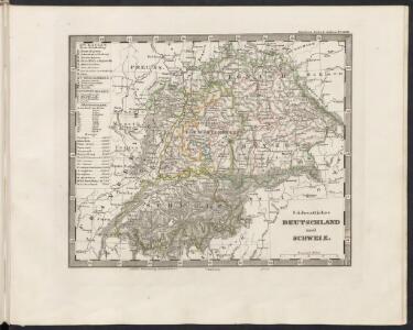
Südwestliches Deutschland und Schweiz
Schul-Atlas über alle Theile der Erde nach dem neuesten Zustande, und über das Weltgebäude Stieler, Adolf Justus Perthes
[36][36] Carta nova accurata del Pasagio et strada dalli Paesi Bassi..., uit: Atlas sive Descriptio terrarum orbis
Annotatie: Gedigitaliseerde versie. Amsterdam. Heiloo : Picturae (vervaardiger), 2015. tiff-bestand. Gedigitaliseerd: 07-01-2015; Origineel: Universiteitsbibliotheek Vrije Universiteit (XL.05127.-) ; Netherlands; Titelpagina ontbreekt Wit, Frederik de Amsterdam : Frederick de Wit
Carta Noua accurata del Paßagio et strada dalli Paesi Baßi per via de Allemagna per Italia et per via di Paesi svizeri à Geneua, Lione et Roma
1 : 2100000 Mollova mapová sbírka Danckertsz, Cornelis Danckerts, Cornelis I.
Carta Noua accurata del Paßagio et strada dalli Paesi Baßi per via de Allemagna per Italia et per via di Paesi svizeri à Geneua, Lione et Roma
1 : 2100000 Mollova mapová sbírka Danckerts, Cornelis Danckerts, Cornelis I.
Carta noua accurata del paßagio et strada dalli Paesi Baßi per via de Allemagna per Italia et per via di paesi Suizeri a Geneua, Lione et Roma per seruizio delli marchanti et viagianti in gen[n]ale ad instanza
1 : 2060000 Itálie Danckertsz, Cornelis Cornelio Dancherts
Carte des confins de la France et des principales postes, de Paris aux païs estrangers
1 Karte : Kupferdruck ; 43 x 44 cm Placide de Sainte Hélène; Duval chez M.elle Du-Ual sur le quay de l'orloge prés le coin de la rüe de Harlay a l'ancien buïs

[Deutschland mit seinen Herzogthuemern]
Historisch-genealogisch-geographischer Atlas von Le Sage Las Cases, Emmanuel Auguste Dieudonné Marius Joseph de Johann Velten, Kunsthändler
Carta Nova accurata del Paßagio et strada dalli Paesi Baßi per via de Allemagna per Italia et per via di Paesi svizeri à Geneva, Lione et Roma per servizio delli Marchanti et ...
Wit
Divisio Regni Lotharii Anni DCCCLXX
1 : 4000000 Mollova mapová sbírka Georgisch, Peter
Regnvm et Imperivm Merovingo-Carolingicvm
1 : 4000000 Mollova mapová sbírka Georgisch, Peter
Germania benedictina qvae in illa sunt monasteria ord. S. Benedicti monstrans
1 : 2400000 Itálie severní Homannianos Heredes
[Deutschland vor und seit dem Westphaelischen Frieden]
Historisch-genealogisch-geographischer Atlas von Le Sage Las Cases, Emmanuel Auguste Dieudonné Marius Joseph de Johann Velten, Kunsthändler
Deutschland, Niederlande, Belgien, Schweiz.
1 : 10000000 Brudin, J. L.; Stieler, Adolf
[Hl. Röm. Reich dt. Nation]
Deutschland
Germania Benedictina qvae in illa sunt Monasteria Ord. S. Benedicti monstrans.
1 : 2500000 Mollova mapová sbírka Homann, Johann Baptist Homann, Johann Baptista - dědici
L'empiré d'Allemagne
1 : 1420000 Burgundsko (Francie) Jaillot, Alexis-Hubert Ottens, Josua Reinier & Iossua Ottens
[Historisch-geographischer Atlas zu den allgemeinen Geschichtswerken von C. v. Rotteck, Pölitz u. Becker] : Deutschland während des dreissigjährigen Krieges 1618-1648
von Julius Loewenberg Lithographie von B. Herder in Freiburg im Breisgau 1836 [Freiburg im Breisgau] : [Herder]
Tabula Geographica totius Germaniae
1 : 2500000 Mollova mapová sbírka Homann, Johann Baptist Homann, Johann Baptista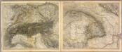
Alpen- u. Donaulaender.
1 : 1900000 Stein, Christ. Gottfr. Dan.
Imperio d'Allemagna
1 : 3000000 Mollova mapová sbírka Sanson, Nicolas Widman, Giorgio De Rossi, Giovanni Giacomo
S. R. I. in Germania Descriptio
1 : 2300000 Mollova mapová sbírka Wit, Frederik de Covens, Johannes I
Nova et denuo correcta Germaniae Tabula
1 : 2400000 Mollova mapová sbírka Allard, Carel Allard, Carel
Allemagne occidentale.
1 : 2000000 Andriveau-Goujon, J.
Allemagne, distinguée en ses Cercles & subdivisée en ses Etats
1 : 2500000 Mollova mapová sbírka Schatz, Johann Jakob Homann, Johann Baptista - dědici
Hydrographia Germaniae
1 : 2400000 Mollova mapová sbírka Zollmann, Philipp Heinrich Homann, Johann Baptista - dědici
Hydrographica Germaniae Delineatio qua celebriorum Germaniae Fluvior Scaturigines, cursus et Ostia Oculis proponuntur
1 : 2500000 Mollova mapová sbírka Seutter, Matthäus Lotter, Tobias Conrad Seutter, Matthäus
Germaniae = L’empire d’Allemagne distingué suivant l’étendue de tous les estats, principautés et souverainetés qui passent ou qui ont passé jusque a present sous le nom d’Allemagne
1 : 900000 sur les memoires les plus nouveaux de Mss. Sanson, de L'Isle Iaillot, de Fer, &c. A Amsterdam : par I. Cóvens et C. Mortier
[Deutschland und anliegende Länder zur Übersicht , d. Hauptstr. u. Entfernungen zw. Paris, Mailand, Warschau u. Königsberg]
Stieler's Hand-Atlas Stieler, Adolf bei Justus Perthes