Maps of Germany

Allemagne occidentale.
1 : 2000000 Andriveau-Goujon, J.
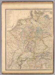
Post und Reise-Karte von Deutschland und den anliegenden Ländern für Extraposten, Couriere, Diligencen und Eilwagen
Evropa střední Bär, Johann Christoph Diez, F. M. J. Perthes
Post und Reise-Karte von Deutschland und den anliegenden Ländern für Extraposten, Couriere, Diligencen und Eilwagen
Evropa střední Bär, Johann Christoph Diez, F. M. J. Perthes
Post und Reise-Karte von Deutschland und den anliegenden Ländern für Extraposten, Couriere, Diligencen und Eilwagen
Evropa střední Bär, Johann Christoph Diez, F. M. J. Perthes
[Kaart], uit: G. Freytags Übersichtskarte des Deutsch-Französischen Kriegsschauplatzes
1 : 2000000 titelvariant: Übersichtskarte des Deutsch-Französischen Kriegsschauplatzes; Annotatie: Omslagtitel: Übersichtskarte des Deutsch-Französischen Kriegsschauplatzes Freytag, G. Wien : Freytag & Berndt
G. Freytags Übersichtskarte des deutsch-französischen Kriegsschauplatzes
1 : 2000000 Evropa západní Kartogr. Anstalt G. Freytag & Berndt
Landtaflen
1 Atlas [von Johannes Stumpf] Christoffel Froschower, Zürych
Germania, V. Nova Tabula. [Karte], in: Geographia universalis vetus et nova complectens Claudii Ptolemaei Alexandrini enarrationis libros VIII, S. 314.
1 Karte aus Atlas Münster, Sebastian [und Ptolemaeus, Claudius]
Eisenbahn-Karte von Mittel-Europa
1 : 8200000 Evropa střední
Verbreitung der wichtigsten Kulturgewächse
Evropa střední F.A. Brockhaus Geogr. artist. Anstalt
Übersicht der Schnellpost und Eilwagen, ... Deutschland

[Západní Evropa]
1 : 1600000 Evropa západní Fastrův mapový atelier
Deutschland physikalisch.
1 : 3400000 Andree, Richard
Hydrographica Germaniae...

Reise - Karte von Deutschland und den Nachbarstaaten

Střední Evropa v zájmu světového míru
1 : 5000000 Evropa střední Kuffner, Hanuš
Mitteleuropa Übersicht der politischen Verhältnisse und Hauptverkehrswege
1 : 5000000 Mitteleuropa Verkehrsnetz
VIII. Charte für die allgemeine Geschichte von Rudolph von Habsburg bis auf Carl V : d.i. von 1273-1519 nach Christus
Entworfen von F.W. Benicken gez. von C.F. Weiland ; in Stein gravirt v. Ant. Falger Weimar : im Verlage des L. Industrie-Comptoirs
Neue und vollständige Postkarte durch ganz Deutschland und durch die angränzende Theile der benachbarten Länder / zusammen getragen und ausgefertiget von Franz Joseph Heger = Nouvelle carte geographique des postes d'Allemagne et des provinces limitrophes
1 : 1500000 titelvariant: Nouvelle carte geographique des postes d'Allemagne et des provinces limitrophes; Annotatie geografische gegevens: Legenda in het Duits en Frans Heger, Franz Joseph In Nürnberg : im Verlag bey denen Homaennischen Erben
Germania, V. Nova Tabula. [Karte], in: Claud. Ptolemaeus. Geographia lat. cum mappis [...], S. 347.
1 Karte aus Atlas Münster, Sebastian [und Ptolemaeus, Claudius]
Mitteleuropa Übersicht der Bodenverhältnisse
1 : 5000000 Mitteleuropa
Deutschland 1555
Deutschland Kunz, Andreas ; Moeschl, Joachim Robert
Imperium Romano-Germanicum in suos circulos electorat. et status
1 : 2700000 Evropa střední Seutter, Matthäus apud Matth. Seutter
Imperium Romano-Germanicum in suos circulos electorat. et status
1 : 2700000 Evropa střední Seutter, Matthäus Matth. Seutter
Imperium Romano-Germanicum in suos circulos electorat. et status
1 : 2700000 Evropa střední Seutter, Matthäus Matth. Seutter
Post- und Reise-Karte von Deutschland und den anliegenden Laendern bis London, Havre de Grace, Tours, Lyon, Genua, Bologna, Pest, Warschau, Königsberg u. jenseits Kopenhagen, nebst den Haupt-Routen durch das übrige Europa
1 : 1490000 Belgie Diez, F. M. Perthes, Justus Justus Perthes
Post- und Reise-Karte von Deutschland und den anliegenden Ländern bis London, Havre de Grace, Tours, Lyon, Genua, Bologna, Pest, Warschau, Königsberg u. jenseits Kopenhagen, nebst den haupt Routen durch das übrige Europa
1 : 1490000 Belgie Diez, F. M. Justus Perthes
Imperium Romano-Germanicum
1 : 2600000 Mollova mapová sbírka Seutter, Matthäus Seutter, Matthäus