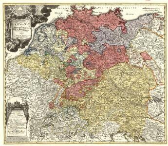
Maps of Germany

Tabula Geographica totius Germaniae
1 : 2500000 Mollova mapová sbírka Homann, Johann Baptist Homann, Johann Baptista
Imperio d'Allemagna
1 : 3000000 Mollova mapová sbírka Sanson, Nicolas Widman, Giorgio De Rossi, Giovanni Giacomo
S. R. I. in Germania Descriptio
1 : 2300000 Mollova mapová sbírka Wit, Frederik de Covens, Johannes I
Nova et denuo correcta Germaniae Tabula
1 : 2400000 Mollova mapová sbírka Allard, Carel Allard, Carel
Allemagne, distinguée en ses Cercles & subdivisée en ses Etats
1 : 2500000 Mollova mapová sbírka Schatz, Johann Jakob Homann, Johann Baptista - dědici
Hydrographia Germaniae
1 : 2400000 Mollova mapová sbírka Zollmann, Philipp Heinrich Homann, Johann Baptista - dědici
Hydrographica Germaniae Delineatio qua celebriorum Germaniae Fluvior Scaturigines, cursus et Ostia Oculis proponuntur
1 : 2500000 Mollova mapová sbírka Seutter, Matthäus Lotter, Tobias Conrad Seutter, Matthäus
Charte welche das Deutsche Reich nach seinen Kreisen und Staaten vorstellet
1 : 2660000 Evropa střední Homann, Johann Baptist Schatz, Johann Jakob bey den Homaennischen Erben
Germaniae = L’empire d’Allemagne distingué suivant l’étendue de tous les estats, principautés et souverainetés qui passent ou qui ont passé jusque a present sous le nom d’Allemagne
1 : 900000 sur les memoires les plus nouveaux de Mss. Sanson, de L'Isle Iaillot, de Fer, &c. A Amsterdam : par I. Cóvens et C. Mortier
Accuratissima Germaniae Tabula Denuo in lucem edita
1 : 2400000 Mollova mapová sbírka Wit, Frederik de Ottens, Josua
Accuratißima totius Germaniae Tabula Novissime in lucem edita
1 : 2400000 Mollova mapová sbírka Funck, David Homann, Johann Baptist Funck, David
Accuratissima Germaniae Tabula
1 : 2500000 Mollova mapová sbírka Danckerts, Justus Danckerts, Justus

Hydrographia Germaniae
Evropa střední Homann, Johann Baptist operâ Ioh. Baptistae Homani
Hydrographia Germaniae
1 : 2500000 Evropa střední Homann, Johann Baptist J.B. Homann
L Alemagna
1 : 7100000 Evropa střední Zatta, Antonio Zatta
Imperii Romano-Germanici in svos statvs et circvlos divisi tabvla generalis in usus iuventutis erudiendae accommodata
1 : 2560000 Evropa střední Homann, Johann Baptist Schatz, Johann Jakob Schatz
Imperii Romano-Germanici in svos statvs et circvlos divisi tabvla generalis in usus iuventutis erudiendae accommodata
1 : 2600000 Evropa střední Homann, Johann Baptist Schatz, Johann Jakob Ioh. Bapt. Homann
Deutschland, Niederlande und Schweiz
Hand-Atlas über alle Theile der Erde nach dem neuesten Zustande und über das Weltgebäude Stieler, Adolf bei Justus Perthes
Teutschland die Niederlande und die Schweiz
1 : 2860000 Nizozemsko Streit, Friedrich Wilhelm Boreux, J. J. C. Hinrichssche Buchhandlung
Mappa chorographica Omnivm Episcopatvvm Germaniae ab AC. MD ad MDCCLX existentium
1 : 2600000 Mollova mapová sbírka Hartzheim, Josephus Homann, Johann Baptista - dědici
Tabula geographica totius Germaniae
1 : 2426000 Německo Homann, Johann Baptist J. B. Homann
Germania Seraphico-Observans seu Provinciae Fratrum Minorum strictioris Observantiae, in Germania sitae
1 : 2700000 Mollova mapová sbírka Seutter, Matthäus Seutter, Albrecht Carl Seutter, Matthäus
Imperii Romano-Germanici
1 : 2400000 Mollova mapová sbírka Schatz, Johann Jakob Homann, Johann Baptista - dědici
Imperii Romano-Germanici
1 : 2400000 Mollova mapová sbírka Schatz, Johann Jakob Homann, Johann Baptista - dědici
Imperium Romano-Germanicum
1 : 2400000 Mollova mapová sbírka Homann, Johann Baptist Homann, Johann Baptista - dědici
Imperium Romano-Germanicum
1 : 2400000 Mollova mapová sbírka Homann, Johann Baptist Homann, Johann Baptista - dědici
Neue Postkarte von Deutschland und einem Theile Frankreichs
Německo in Verlage der Schrämblischen Buchdruckerey
Nova totius Germaniae Descriptio Teütschland
1 : 4300000 Mollova mapová sbírka Merian, Matthaeus Merian, Matthäus