Maps of Třemešné

Pabelsdorf - c5660-2-002 - Kaiserpflichtexemplar der Landkarten des stabilen Katasters
1 : 2880
Pabelsdorf - c5660-2-001 - Kaiserpflichtexemplar der Landkarten des stabilen Katasters
1 : 2880
Pabelsdorf - c5660-2-003 - Kaiserpflichtexemplar der Landkarten des stabilen Katasters
1 : 2880
Tuz - c1583-1-002 - Kaiserpflichtexemplar der Landkarten des stabilen Katasters
1 : 2880
Tuz - c1583-1-001 - Kaiserpflichtexemplar der Landkarten des stabilen Katasters
1 : 2880
Czernahora (Cernahora) - c0869-1-002 - Kaiserpflichtexemplar der Landkarten des stabilen Katasters
1 : 2880
Czernahora (Cernahora) - c0869-1-001 - Kaiserpflichtexemplar der Landkarten des stabilen Katasters
1 : 2880
Czernahora (Cernahora) - c0869-1-003 - Kaiserpflichtexemplar der Landkarten des stabilen Katasters
1 : 2880
Zemschen (Cemssen) - c8064-1-003 - Kaiserpflichtexemplar der Landkarten des stabilen Katasters
1 : 2880
Zemschen (Cemssen) - c8064-1-002 - Kaiserpflichtexemplar der Landkarten des stabilen Katasters
1 : 2880
Zemschen (Cemssen) - c8064-1-001 - Kaiserpflichtexemplar der Landkarten des stabilen Katasters
1 : 2880


Pfraumberg
1 : 75000 Poběžovice (Domažlice, Česko : oblast) Kimlein K. u. k. militär-geographisches Institut
Pfraumberg
1 : 75000 Poběžovice (Domažlice, Česko : oblast) Kimlein K. u. k. Militärgeographisches Institut
Pfraumberg
1 : 75000 Přimda-oblast (Česko) K. u. k. Militärgeographisches Institut
III. vojenské mapování 4149
1 : 75000
Politický okres Tachov
1 : 75000 Tachov (Česko : okres : 1960-) Vojenský zeměpisný ústav
Politický okres Tachov
Böhmerwald-Verbindungsbahn
1 : 75000 Domažlice-Planá u Mariánských Lázní (Česko : železniční trať) Technisches Bureau Ing. Max Picha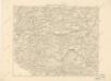
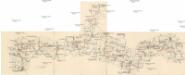
Podrobná místopisná mapa Království Českého

Podrobná mapa Království českého
1 : 100000 Domažlice (Česko : oblast) Srp, Jan Jaroslav Bursík
II. vojenské mapování 23
1 : 144000
Pfraumberg.
from Spezialkarte der osterreichisch-ungarischen Monarchie.
Umgebungen von Plan und Hayd
1 : 750000 Bor (Tachov, Česko : oblast) Kiss, Josef K. k. militär-geographisches Institut
155. Tirschenreuth (bijgeschreven: Eslam), uit: Topographische Uebersichtskarte des Deutschen Reiches / herausgegeben v. d. Kartogr. Abt. d. Königl. Preuß. Landesaufnahme
1 : 200000 titelvariant: Topogr. Übersichtskarte des Deutschen Reiches; Annotatie: Titel boven bladen ook: Topogr. Übersichtskarte des Deutschen Reiches; Annotatie geografische gegevens: Op elk blad twee maatstokken: 10 Kilometer = 5,5 cm; 1 geogr. Meile = 3,6 cm; Legenda onder op elk blad Königlich Preußische Landesaufnahme. Kartographische Abtheilung [S.l : Königlich Preußische Landesaufnahme, Kartographische Abtheilung]
Müllerova mapa Čech
1 : 132000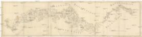
[Böhmerwald und die Umgebung von Eger]
1 : 80000 Cheb-oblast (Česko)
Fischerei-Karte des Radbusa-Gebietes
Radbuza-oblast (Česko) Schubert, Ottokar Deutsche agrarische Druckerei