Maps of okres Tachov
Müllerova mapa Čech
1 : 132000
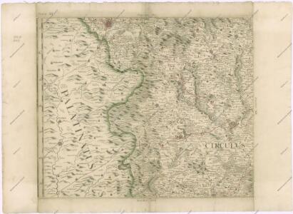
Sacri Romani imperii circuli et electoratus Bavariae tabula, 2
4 Blätter : s.n.
[Böhmerwald und die Umgebung von Eger]
1 : 80000 Cheb-oblast (Česko)
Umgebungen von Plan und Hayd
1 : 750000 Bor (Tachov, Česko : oblast) Kiss, Josef K. k. militär-geographisches Institut
155. Tirschenreuth (bijgeschreven: Eslam), uit: Topographische Uebersichtskarte des Deutschen Reiches / herausgegeben v. d. Kartogr. Abt. d. Königl. Preuß. Landesaufnahme
1 : 200000 titelvariant: Topogr. Übersichtskarte des Deutschen Reiches; Annotatie: Titel boven bladen ook: Topogr. Übersichtskarte des Deutschen Reiches; Annotatie geografische gegevens: Op elk blad twee maatstokken: 10 Kilometer = 5,5 cm; 1 geogr. Meile = 3,6 cm; Legenda onder op elk blad Königlich Preußische Landesaufnahme. Kartographische Abtheilung [S.l : Königlich Preußische Landesaufnahme, Kartographische Abtheilung]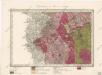
Umgebungen von Plan und Hayd

II. vojenské mapování 17
1 : 144000
Marienbad und Tachau.
from Spezialkarte der osterreichisch-ungarischen Monarchie.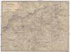
Umgebung von Aussig
1 : 110000 Ústí nad Labem-oblast (Česko) Doležal Medau, Karel Vilém C.W. Medau
Generalkarte der Bezirkshauptmannschaft Tepl
1 : 220000 Teplá-oblast (Cheb, Česko) Wagner, Jan Eduard F. Kytka
Generální mapa okresních hejtmanství

Pfraumberg.
from Spezialkarte der osterreichisch-ungarischen Monarchie.
Theil von Baierno
Bavorsko (Německo) im Verlage des Geogr. Instituts
Vilímkovy místopisné mapy zemí Koruny české
1 : 100000 Chodová Planá (Česko : oblast) Srp, Jan Jos. R. Vilímek
Podrobná mapa Království českého
1 : 100000 Planá (Tachov, Česko : oblast) Srp, Jan Jaroslav Bursík
Politický okres Tachov

Politický okres Tachov
1 : 75000 Tachov (Česko : okres : 1960-) Vojenský zeměpisný ústav
III. vojenské mapování 4149
1 : 75000
III. vojenské mapování 4049
1 : 75000
Mariánské Lázně
1 : 75000 Mariánské Lázně (Česko : oblast) Vojenský zeměpisný ústav
Mariánské Lázně
1 : 75000 Mariánské Lázně-oblast (Česko) Vojenský zeměpisný ústav
Mariánské Lázně
1 : 75000 Chodová Planá (Česko : oblast) Vojenský zeměpisný ústav
Přehledová mapa velkostatku Tachov
1 : 17280
Marienbad und Tachau
1 : 75000 Mariánské Lázně (Česko : oblast) Höller, K. K. u. k. Militärgeographisches Institut
Marienbad und Tachau
1 : 75000 Mariánské Lázně (Česko : oblast) K. u. k. Militärgeographisches Institut
Pfraumberg
1 : 75000 Poběžovice (Domažlice, Česko : oblast) Kimlein K. u. k. militär-geographisches Institut
Pfraumberg
1 : 75000 Poběžovice (Domažlice, Česko : oblast) Kimlein K. u. k. Militärgeographisches Institut
Pfraumberg
1 : 75000 Přimda-oblast (Česko) K. u. k. Militärgeographisches Institut
Hayder Vicariat
Bor-oblast (Tachov, Česko)