Maps of okres Tachov

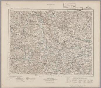
155. Tirschenreuth (bijgeschreven: Eslam), uit: Topographische Uebersichtskarte des Deutschen Reiches / herausgegeben v. d. Kartogr. Abt. d. Königl. Preuß. Landesaufnahme
1 : 200000 titelvariant: Topogr. Übersichtskarte des Deutschen Reiches; Annotatie: Titel boven bladen ook: Topogr. Übersichtskarte des Deutschen Reiches; Annotatie geografische gegevens: Op elk blad twee maatstokken: 10 Kilometer = 5,5 cm; 1 geogr. Meile = 3,6 cm; Legenda onder op elk blad Königlich Preußische Landesaufnahme. Kartographische Abtheilung [S.l : Königlich Preußische Landesaufnahme, Kartographische Abtheilung]
Umgebungen von Plan und Hayd
1 : 750000 Bor (Tachov, Česko : oblast) Kiss, Josef K. k. militär-geographisches Institut
II. vojenské mapování 17
1 : 144000
Umgebungen von Plan und Hayd

Generalkarte der Bezirkshauptmannschaft Mies
1 : 220000 Stříbro-oblast (Česko) Wagner, Jan Eduard F. Kytka
Vilímkovy místopisné mapy zemí Koruny české
1 : 100000 Chodová Planá (Česko : oblast) Srp, Jan Jos. R. Vilímek
Podrobná mapa Království českého
1 : 100000 Planá (Tachov, Česko : oblast) Srp, Jan Jaroslav Bursík
[Okolí Plzně - západ]
Plzeň-oblast (Česko) Krejčí, Jan Schwarzenberg, Bedřich
Politický okres Tachov

Politický okres Tachov
1 : 75000 Tachov (Česko : okres : 1960-) Vojenský zeměpisný ústav
Karte des Bezirke Mies und Pilsen

Stříbro a okolí
1 : 75000 Stříbro (Česko : oblast) Vojenský zeměpisný ústav
III. vojenské mapování 4149
1 : 75000
III. vojenské mapování 4150
1 : 75000
Horšovský Týn
1 : 75000 Horšovský Týn-oblast (Česko) Vojenský zeměpisný ústav
Tepl und Tuschkau.
from Spezialkarte der osterreichisch-ungarischen Monarchie.
Bischofteinitz und Nürschan
1 : 75000 Horšovský Týn (Česko : oblast) Mulacz, J. K. u. k. militär-geographisches Institut
Bischofteinitz und Nürschan
1 : 75000 Horšovský Týn (Česko : oblast) Mulacz, J. K. u. k. Militärgeographisches Institut
Bischofteinitz und Nürschan
1 : 75000 Horšovský Týn (Česko : oblast) K. u. k. Militärgeographisches Institut
Marienbad und Tachau.
from Spezialkarte der osterreichisch-ungarischen Monarchie.
Pfraumberg.
from Spezialkarte der osterreichisch-ungarischen Monarchie.
Bischofteinitz und Nurschan.
from Spezialkarte der osterreichisch-ungarischen Monarchie.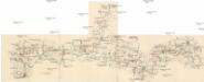
Böhmerwald-Verbindungsbahn
1 : 75000 Domažlice-Planá u Mariánských Lázní (Česko : železniční trať) Technisches Bureau Ing. Max Picha
Pfraumberg
1 : 75000 Poběžovice (Domažlice, Česko : oblast) Kimlein K. u. k. militär-geographisches Institut
Pfraumberg
1 : 75000 Poběžovice (Domažlice, Česko : oblast) Kimlein K. u. k. Militärgeographisches Institut
Pfraumberg
1 : 75000 Přimda-oblast (Česko) K. u. k. Militärgeographisches Institut
Mieser Vicariat
Stříbro-oblast (Česko)
Hayder Vicariat
Bor-oblast (Tachov, Česko)
Uibersichtskarte der Herrschaft Tachau
Tachov-oblast (Česko) Waraus, E. André Verlag des böhm. Forstvereins