Maps of Vidice

Liebeswar - c4044-1-001 - Kaiserpflichtexemplar der Landkarten des stabilen Katasters
1 : 2880
Liebeswar - c4044-1-002 - Kaiserpflichtexemplar der Landkarten des stabilen Katasters
1 : 2880
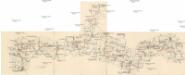
Porostní mapa revíru Sedmihoří
1 : 20000
Porostní mapa revíru Sedmihoří
1 : 10000
Melmitz (Melmice) - c4588-1-002 - Kaiserpflichtexemplar der Landkarten des stabilen Katasters
1 : 2880
Melmitz (Melmice) - c4588-1-003 - Kaiserpflichtexemplar der Landkarten des stabilen Katasters
1 : 2880
Melmitz (Melmice) - c4588-1-004 - Kaiserpflichtexemplar der Landkarten des stabilen Katasters
1 : 2880
Melmitz (Melmice) - c4588-1-001 - Kaiserpflichtexemplar der Landkarten des stabilen Katasters
1 : 2880
Wiedlitz - c8564-1-002 - Kaiserpflichtexemplar der Landkarten des stabilen Katasters
1 : 2880
Wiedlitz - c8564-1-003 - Kaiserpflichtexemplar der Landkarten des stabilen Katasters
1 : 2880
Wiedlitz - c8564-1-001 - Kaiserpflichtexemplar der Landkarten des stabilen Katasters
1 : 2880
Krzeberscham (Křeberžami) - c2662-1-002 - Kaiserpflichtexemplar der Landkarten des stabilen Katasters
1 : 2880
Krzeberscham (Křeberžami) - c2662-1-001 - Kaiserpflichtexemplar der Landkarten des stabilen Katasters
1 : 2880
Krzeberscham (Křeberžami) - c2662-1-003 - Kaiserpflichtexemplar der Landkarten des stabilen Katasters
1 : 2880


Horšovský Týn
1 : 75000 Horšovský Týn-oblast (Česko) Vojenský zeměpisný ústav
Politický okres Tachov
1 : 75000 Tachov (Česko : okres : 1960-) Vojenský zeměpisný ústav
Politický okres Tachov
Böhmerwald-Verbindungsbahn
1 : 75000 Domažlice-Planá u Mariánských Lázní (Česko : železniční trať) Technisches Bureau Ing. Max Picha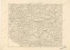
Podrobná místopisná mapa Království Českého

Podrobná mapa Království českého
1 : 100000 Domažlice (Česko : oblast) Srp, Jan Jaroslav Bursík
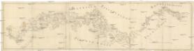
II. vojenské mapování 23
1 : 144000
Bischofteinitz und Nurschan.
from Spezialkarte der osterreichisch-ungarischen Monarchie.
Pfraumberg.
from Spezialkarte der osterreichisch-ungarischen Monarchie.
Umgebungen von Plan und Hayd
1 : 750000 Bor (Tachov, Česko : oblast) Kiss, Josef K. k. militär-geographisches Institut
Generalkarte der Bezirkshauptmannschaft Mies
1 : 220000 Stříbro-oblast (Česko) Wagner, Jan Eduard F. Kytka
155. Tirschenreuth (bijgeschreven: Eslam), uit: Topographische Uebersichtskarte des Deutschen Reiches / herausgegeben v. d. Kartogr. Abt. d. Königl. Preuß. Landesaufnahme
1 : 200000 titelvariant: Topogr. Übersichtskarte des Deutschen Reiches; Annotatie: Titel boven bladen ook: Topogr. Übersichtskarte des Deutschen Reiches; Annotatie geografische gegevens: Op elk blad twee maatstokken: 10 Kilometer = 5,5 cm; 1 geogr. Meile = 3,6 cm; Legenda onder op elk blad Königlich Preußische Landesaufnahme. Kartographische Abtheilung [S.l : Königlich Preußische Landesaufnahme, Kartographische Abtheilung]
Müllerova mapa Čech
1 : 132000