Maps of Holešovice

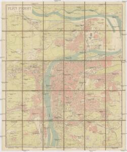
Plán Prahy I-VII
1 : 10000 Praha (Česko) Hurtig, Alfred Marek, V. Alfred Hurtig
Nejnovější a nejúplnější plán královského hlav. města Prahy, Karlína, Žižkova, Královských Vinohradů, Vršovic, Nuslí, Smíchova a nejbližšího okolí
1 : 12000 Karlín (Praha, Česko) Brož, Josef A. Storch syn
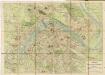
Plán Prahy s okolím
1 : 10000 Praha (Česko) Hurtig, Alfred Alfred Hurtig
Plán Prahy s okolím
1 : 10000 Praha (Česko) Hurtig, Alfred Alfred Hurtig
Plán Prahy s okolím
Praha (Česko) Hurtig, Alfred Mikolášek, Antonín Alfred Hurtig
Nejnovější plán král. hlav. města Prahy a předměstí
1 : 10000 Praha (Česko) Hurtig, Alfred Schraembl, Franz Anton V. K. K. V.
Neuester Plan von Prag mit seiner Umgebungen
1 : 18000 Praha (Česko) bei Gottl. Haase Söhne
Neuester Haase'scher Plan von Prag und der nächsten Umgebung
1 : 11725 Praha (Česko) A. Haase
Nejnovější Haasovský plán Prahy s nejbližším okolím
Praha (Česko) Routa, F. Grefnetter, Josef A. Haase
Kriegs-Expeditions-Karte in Böhmen I. Blat, in welchem die Haubtstadt Prag mit der französsischen und saechsischen Belageru[n]g und Eroberung, so den 26. Novembre 1741. geschehen, vorgestellet wird
1 : 20700 Praha (Česko) Meyer Sinsart von Homaen[n] Erben
Kriegs-Expeditions-Karte in Böhmen I. Blat, in welchem die Haubtstadt Prag mit der französsischen und saechsischen Belageru[n]g und Eroberung, so den 26. Novembre 1741. geschehen, vorgestellet wird
1 : 20700 Praha (Česko) Meyer Sinsart von Homaen[n] Erben
Militaerisch Topographischer Plan von der Königl. Hauptstadt Prag nebst Umgebungen

Neuester Grundriss von Prag und seiner Umgebung

Nejnovější plán Prahy s okolím
Holešovice (Praha, Česko) Brož, Josef Alois Hynek
[Praha]
1 : 61500 Praha (Česko) Basdar, von
Názorný plán Prahy
1 : 7700 Praha (Česko) Lauda, Ladislav Státní ústav pro učebné pomůcky škol průmyslových a odborných
Pharusův plán hlav. města Prahy
1 : 14000 Praha (Česko) Löwe, Cornelius K. André
Grundriß der Prager Stätte
Praha (Česko)
Grundriß des K. K. Hauptstadt Prag und ihres nächsten Umgebungen
Wöltner, Leop [s.n.]
Plán Prahy I - VII

Kurtze doch wahrhaffte Nachricht was waehrend der- durch dem im Jahr 1757. beschehenen Preußischen gewaltsamen Einfall in allhiesiges Koenigreich Boeheim, erlittenen sechswochentlichen harten Belagerung der koenigl. Haupt- und Residenz Stadt Prag, sich zugetragen
Praha (Česko) Breyer, Johanes Nepomuk Salzer, Ignác
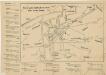
Přehled tratí elektrických drah král. Hlavního města Prahy 1908
Pharusův plán král. hlav. města Prahy
1 : 11500
Plán Prahy I-VII se sousedními obcemi

Plán král. Hlav. Města Prahy
Nové tratě elektrických drah hlav. města Prahy

Plán Prahy s okolím
1 : 10000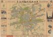
Praha

Militærisch topographischer Plan von der königl. Hauptstadt Prag nebst Umgebungen