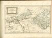
Maps of Aschaffenburg
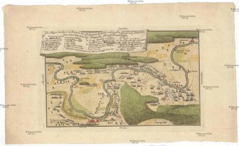
Der Mayn Strohm, von Obernau bis Seeligenstadt sambt umliegender Gegend, und sonderlich dem, d. 27 Juni 1743. bey Dettingen fürgefallenen Treffen

Gründliche Vorstellung des bey Dettingen den 27 Juny lauffenden 1743 Jahrs vorbeygegangenen
Mollova mapová sbírka
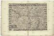
Eigendlicher Grundriß der Statt Aschaffenburg
Mollova mapová sbírka Merian, Matthaeus Merian, Matthäus
[Gefechtsfelder bei Würzburg und Aschaffenburg von 1866]
1 : 50000
Topographische Karte des Frankfurter Gebietes mit der Umgegend bis Mainz, Idstein, Friedberg, Aschaffenburg u. Darmstadt
1 : 100000 Frankfurt nad Mohanem (Německo) Ravenstein, August Dondorf August Ravenstein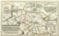
Geographische Vorstellung der Gegend zwischen Franckfurt und Aschaffenburg darinnen beyde Kriegen de Armeen wie sie gelagert, und alle s. wohl große als kleine Öhrfer Waldungen Flüß, Teich sambt alle Gräntz Scheidungen auf das accurateste dargestellet seynd
Mollova mapová sbírka
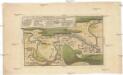
Plan des Baillages D'Umstatt et D'Otzberg
Reuling, Louis
Carte von dem zwischen Chur Pfalz und Hessen Darmstadt Gemeinschaftlichen OberAmt Umstadt mit den Centorten
Beck, G. C. W.
Section Darmstadt, uit: Charte von dem Grossherzogtum Hessen und dem Herzogtum Nassau / trigonometrisch aufgenommen und hrsg. von C.L.P. Eckhardt
1 : 200000 titelvariant: Karte von Hessen und Nassau Eckhardt, C. L. P Darmstadt : Joh. Wilh. Heyer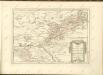

Delineatio Geographica generalis comprehendens VI. Foliis Singulos Principatvs Comitatvs Ditiones Dynastias omnes quotquot Imperio Serenissimi Principis Landgrafii Hasso-Darmstadiensis subsunt :
1 : 180000 Mollova mapová sbírka Bronner, Christian Maximilian Homann, Johann Baptista - dědici
S. R. Imp. Comitatus Hanau proprie sic dictus, cum singulis suis Praefecturis, ut et Comitatus Solms Budingen et Nidda cumreliqua Wetteravia et vicinis Regionibus
1 : 230000 Mollova mapová sbírka Zollmann, Friedrich Homann, Johann Baptista - dědici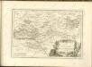

Partie Orientale du Temporel de l'Archevesché et Eslectorat de Mayence et le Comté de Reineck
1 : 250000 Mollova mapová sbírka Sanson, Guillaume Jaillot, Alexis Hubert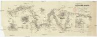
Der Lauf des Mains
1 : 370000 Aschaffenburg (Německo) Spruner, Karl von Verlag der Stahel'schen Buchhandlung
Geognostische Karte von dem Odenwald und einigen angraenzenden Gegenden
1 : 235000 Odenwald, pohoří (Německo) Klipstein, A. MK
Pars Occidentalis Temporalis Archiepiscopatvs, et Electoratvs Mogvntinensis, nec non Superioris et inferioris Comitatus Cattimellebogensis
1 : 210000 Mollova mapová sbírka Walther, Johann Georg Hailler, Martin Walther, Johann Georg
Das Franken-Weinland
1 : 493000 Bavorsko (Německo) Hellrung, Carl Ludwig Baensch, E. Rubach'schen Buchhandlung
Partie Orientale du Temporel de l'Archevesché et Eslectorat de Mayence et le Comté de Reineck
1 : 250000 Mollova mapová sbírka Sanson, Guillaume Covens, Johannes I
Pars Orientalis Temporalis Archiepiscopatvs et Electoratvs Mogvntinensis et Comitatus Reineck
1 : 260000 Mollova mapová sbírka Walther, Johann Georg Hailler, Martin Walther, Johann Georg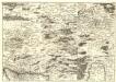
S. R. Imp. Circuli Franconici Geographica Delineatio Francken-Land mit Seinen Gräntzen
Mollova mapová sbírka Endter, Wolfgang Moritz Endter, Wolfgang Moritz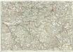
[...] Principatus & comitatus superioris Ysenburgensis, ac Hanoviensis, nova et accurata tabula, cum regionibus adjacentibus
Mohan (Německo) Buna, Wilhelm C. Brönner, Heinrich Ludwig Heinrich Ludwig Broenner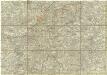
[Dolní Mohan a Porýní]
Mohan (Německo) Buna, Wilhelm C.
Partie Occidentale Du Temporel De L'Archevesché et Eslectorat De Mayence et le Haut et Bas Comté de Catzenellenboge [Karte], in: Atlas nouveau, contenant toutes les parties du monde [...], Bd. 1, S. 188.
1 Karte aus Atlas Sanson, Nicolas Jaillot, Alexis Hubert und Mortier, Pieter
Provinz Starkenburg und Rheinhessen
1 : 250000 Hügel, Adolf Diehl
Partie Orientale Du Temporel De L'Archevesché et Eslectorat De Mayence et le Comté de Reineck [Karte], in: Atlas nouveau, contenant toutes les parties du monde [...], Bd. 1, S. 192.
1 Karte aus Atlas Sanson, Nicolas Jaillot, Alexis Hubert und Mortier, Pieter
Kissingen 100, uit: Special-Karte von Mittel-Europa / nach amtlichen Quellen bearbeitet von W. Liebenow
1 : 300000 titelvariant: W. Liebenow's Mittel-Europa; Annotatie: Titel boven de bladen: W. Liebenow's Mittel-Europa Johannes Wilhelm Liebenow 1822-1897 Frankfurt a. M. : Ludwig Ravenstein
Provinz Starkenburg und Rheinhessen
1 : 250000 Hügel, Adolf Diehl