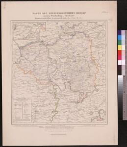
Maps of Regierungsbezirk Darmstadt

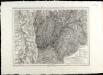
Provinz Starkenburg und Rheinhessen
1 : 250000 Hügel, Adolf Diehl
Provinz Starkenburg und Rheinhessen
1 : 250000 Hügel, Adolf Diehl
Archiepiscopatus et electoratus Moguntinus
1 : 356600 Koblenz (Německo) Lotter, Tobias Conrad Tob. Conradum Lotter
[Porýní-Falc]
Porýní-Falc (Německo)
Geognostische Karte von dem Odenwald und einigen angraenzenden Gegenden
1 : 235000 Odenwald, pohoří (Německo) Klipstein, A. MK
Mannheim 113, uit: Special-Karte von Mittel-Europa / nach amtlichen Quellen bearbeitet von W. Liebenow
1 : 300000 titelvariant: W. Liebenow's Mittel-Europa; Annotatie: Titel boven de bladen: W. Liebenow's Mittel-Europa Johannes Wilhelm Liebenow 1822-1897 Frankfurt a. M. : Ludwig Ravenstein
Eigentliche Entwerffung deßn Marquis Spinolae Lägern bey Maintz und Oppenheim
Mohuč (Německo)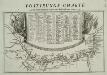
Postirungs-Charte Der am Rhein stehenden Kayserl. und Reichs-Armee Anno 1735
1 : 465000
Partie Orientale du Palatinat et Eslectorat du Rhein. Les Eveschés de Spire, de Wormes et le Comté de Linange
1 : 260000 Mollova mapová sbírka Sanson, Guillaume Jaillot, Alexis Hubert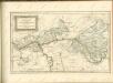

Partie Occidentale Du Temporel De L'Archevesché et Eslectorat De Mayence et le Haut et Bas Comté de Catzenellenboge [Karte], in: Atlas nouveau, contenant toutes les parties du monde [...], Bd. 1, S. 188.
1 Karte aus Atlas Sanson, Nicolas Jaillot, Alexis Hubert und Mortier, Pieter
Mannheim 113, uit: [W. Liebenow's Special-Karte von Mittel-Europa]
1 : 300000 titelvariant: W. Liebenow's Mittel-Europa; Annotatie: Titel boven de bladen: W. Liebenow's Mittel-Europa Johannes Wilhelm Liebenow 1822-1897 Hannover : Hermann Oppermann
Special Carte des Rheinlaufes von Speier bis Bingen nebst den angraentzenden Gegenden von beiden Ufern bis an die Gebirge
1 : 250000 Bingen (Německo) Dewarat, Peter Verhelst, Aegid Schwan und Götz
Geognostische Reise-Karte der Umgegend von Heidelberg
1 : 250000 Groos
Le Cours du Rhein, depuis Spire jusqu'a Mayence
1 : 180000 Mollova mapová sbírka Fer, Nicolas de Fer, Nicolas de
Pars Occidentalis Temporalis Archiepiscopatvs, et Electoratvs Mogvntinensis, nec non Superioris et inferioris Comitatus Cattimellebogensis
1 : 210000 Mollova mapová sbírka Walther, Johann Georg Hailler, Martin Walther, Johann Georg
Partie Occidentale du Temporel de l'Archevesché et Eslectorat de Mayence et le Haut et Bas Comté de Catzenellenboge
1 : 250000 Mollova mapová sbírka Sanson, Guillaume Jaillot, Alexis Hubert
Partie Occidentale du Temporel de l'Archevesché et Eslectorat de Mayence et le Haut et Bas Comté de Catzenellenboge
1 : 250000 Mollova mapová sbírka Sanson, Guillaume Jaillot, Alexis Hubert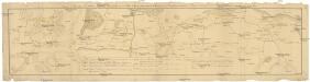
Camps et marches de l'armée imperiale com[m]andée par S.A.S. le prince de Savoye pour retourner de Wesenthal prés de Philippsbourg, et aller passer le Rhein a Mayence, l'armée de France étant campé a Oppenheim prés de céte ville
Mannheim (Německo) Müller, Johann Conrad
SpecialKarte von dem Odenwald, dem Bauland und einem Theil des Spessart's
1 : 216000 Haas, Johann Heinrich; Meister, G.; Felsing, Conrad
Partie du Cours du Palatinat du Rhin Levesché de Spire et de Worms les Comté de Spanheim et de Linange levée Sur les lieu
1 : 160000 Mollova mapová sbírka Baillieul, Gaspard Bailleul, Gaspard
Karte eines Theils des ehemaligen Departement des Donnersberges nach Cantons eingetheilt
1 : 178300 Mohuč (Německo : oblast) Veil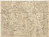
Kriegs Theater der teutschen und franzoesischen Graenz Landen zwischen dem Rhein und der Mosel, im Jahr 1794
1 : 90000 Mosel (Německo) Dewarat, Peter Leizel, Balthasar Friedrich I.L.C. Rheinwald
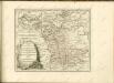
Territorium Seculare Episcopatus Wormatiensis Tabula Geographica
1 : 130000 Mollova mapová sbírka Homann, Johann Baptist Homann, Johann Baptista - dědici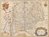
Erpach Comitatus. [Karte], in: Theatrum orbis terrarum, sive, Atlas novus, Bd. 1, S. 260.
1 Karte aus Atlas Blaeu, Joan Blaeu, Willem Janszoon
Erpach Comitatus. [Karte], in: Le théâtre du monde, ou, Nouvel atlas contenant les chartes et descriptions de tous les païs de la terre, Bd. 1, S. 299.
1 Karte aus Atlas Blaeu, Willem Janszoon und Blaeu, Joan Blaeu, Willem Janszoon
Erpach Comitatus
1 : 170000 Mollova mapová sbírka Keere, Pieter van den Schenk, Peter I