Maps of Regierungsbezirk Darmstadt

Partie Occidentale Du Temporel De L'Archevesché et Eslectorat De Mayence et le Haut et Bas Comté de Catzenellenboge [Karte], in: Atlas nouveau, contenant toutes les parties du monde [...], Bd. 1, S. 188.
1 Karte aus Atlas Sanson, Nicolas Jaillot, Alexis Hubert und Mortier, Pieter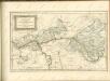

Pars Occidentalis Temporalis Archiepiscopatvs, et Electoratvs Mogvntinensis, nec non Superioris et inferioris Comitatus Cattimellebogensis
1 : 210000 Mollova mapová sbírka Walther, Johann Georg Hailler, Martin Walther, Johann Georg
Kriegs Theater der teutschen und franzoesischen Graenz Landen zwischen dem Rhein und der Mosel, im Jahr 1794
1 : 90000 Mosel (Německo) Dewarat, Peter Leizel, Balthasar Friedrich I.L.C. Rheinwald
Partie Occidentale du Temporel de l'Archevesché et Eslectorat de Mayence et le Haut et Bas Comté de Catzenellenboge
1 : 250000 Mollova mapová sbírka Sanson, Guillaume Jaillot, Alexis Hubert
Partie Occidentale du Temporel de l'Archevesché et Eslectorat de Mayence et le Haut et Bas Comté de Catzenellenboge
1 : 250000 Mollova mapová sbírka Sanson, Guillaume Jaillot, Alexis Hubert
Nassau, Hessen Homburg, Frankfurt a/M.
1 : 340000 Grassl, J. (Joseph)
[Porýní-Falc]
Porýní-Falc (Německo)
Frankfurt a.M. 99, uit: Special-Karte von Mittel-Europa / nach amtlichen Quellen bearbeitet von W. Liebenow
1 : 300000 titelvariant: W. Liebenow's Mittel-Europa; Annotatie: Titel boven de bladen: W. Liebenow's Mittel-Europa Johannes Wilhelm Liebenow 1822-1897 Frankfurt a. M. : Ludwig Ravenstein
Frankfurt 99, uit: [W. Liebenow's Special-Karte von Mittel-Europa]
1 : 300000 titelvariant: W. Liebenow's Mittel-Europa; Annotatie: Titel boven de bladen: W. Liebenow's Mittel-Europa Johannes Wilhelm Liebenow 1822-1897 Hannover : Hermann Oppermann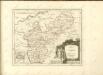

Cursus Rheni a Basilea usque ad Archi-Episcopatum Coloniensem :
1 : 2900000 Mollova mapová sbírka Seutter, Matthäus Seutter, Matthäus
Provinz Starkenburg und Rheinhessen
1 : 250000 Hügel, Adolf Diehl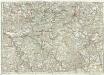
[...] Principatus & comitatus superioris Ysenburgensis, ac Hanoviensis, nova et accurata tabula, cum regionibus adjacentibus
Mohan (Německo) Buna, Wilhelm C. Brönner, Heinrich Ludwig Heinrich Ludwig Broenner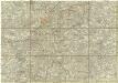
[Dolní Mohan a Porýní]
Mohan (Německo) Buna, Wilhelm C.
Partie Septentrionalo Des Pays qui sont situéz Entre le Rhein, la Saare, la Moselle, et la Basse Alsace. [Karte], in: Atlas nouveau, contenant toutes les parties du monde [...], Bd. 1, S. 238.
1 Karte aus Atlas Sanson, Nicolas Jaillot, Alexis Hubert und Mortier, Pieter
Provinz Starkenburg und Rheinhessen
1 : 250000 Hügel, Adolf Diehl
Charte vom Herzogthum Nassau
1 : 200000 Fembo, Christoph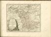

Delineatio Geographica generalis comprehendens VI. Foliis Singulos Principatvs Comitatvs Ditiones Dynastias omnes quotquot Imperio Serenissimi Principis Landgrafii Hasso-Darmstadiensis subsunt :
1 : 180000 Mollova mapová sbírka Bronner, Christian Maximilian Homann, Johann Baptista - dědici
Partie Septentrionalo Des Pays qui sont Situéz Entre le Rhein la Saare, la Moselle, et la Basse Alsace
1 : 150000 Mollova mapová sbírka Mortier, Pieter Covens, Johannes I
Section Mainz, uit: Charte von dem Grossherzogtum Hessen und dem Herzogtum Nassau / trigonometrisch aufgenommen und hrsg. von C.L.P. Eckhardt
1 : 200000 titelvariant: Karte von Hessen und Nassau Eckhardt, C. L. P Darmstadt : Joh. Wilh. Heyer
Nassovia principatus, cum omnibus ei pertinentibus comitatibus dominiiis, ac praefecturis, ut et confiniis intrá Lahnum, Rhenum et Moenum flumina
1 : 1500000 ad situm verum exacte delineatus â Joh. Jac. Stetter [...] excudit Nic. Visscheri vidua Amstelodami : nunc apud Petrum Schenk Iunior
Nassovia Principatus
1 : 170000 Mollova mapová sbírka Stetter, Johann Jakob Schenk, Peter II
Mappa geographica exhibens principatum Nassoviae
1 : 172000 Nasavsko Lotter, Tobias Conrad Lotter, Georg F. sumptibus et curis Tobiae Conradi Lotter
Nassau, Hessen-Homburg, Frankfurt.
1 : 344000 Flemming, Carl
Pars Vederoviae Plurimas Ditiones Princ. et Com. Nassovicor. imprimis verô Regionem Schwalbacensem Acidulis claram
1 : 170000 Mollova mapová sbírka Homann, Johann Baptist Homann, Johann Baptista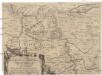
Eigentliche Entwerffung deßn Marquis Spinolae Lägern bey Maintz und Oppenheim
Mohuč (Německo)
Pars Vederoviae plvrimas ditiones princ. et com. Nassovicor. imprimis verô regionem Schwalbacensem acidulis claram exhibens accurate distincta
Hesensko (Německo) Homann, Johann Baptist J. B. Homann
![Partie Occidentale Du Temporel De L'Archevesché et Eslectorat De Mayence et le Haut et Bas Comté de Catzenellenboge [Karte], in: Atlas nouveau, contenant toutes les parties du monde [...], Bd. 1, S. 188.](https://images-2.georeferencer.com/images/iiif/295686200172/full/,300/0/native.jpg)

