Maps of Landkreis Darmstadt-Dieburg

Partie Occidentale du Temporel de l'Archevesché et Eslectorat de Mayence et le Haut et Bas Comté de Catzenellenboge
1 : 250000 Mollova mapová sbírka Sanson, Guillaume Jaillot, Alexis Hubert
Partie Occidentale du Temporel de l'Archevesché et Eslectorat de Mayence et le Haut et Bas Comté de Catzenellenboge
1 : 250000 Mollova mapová sbírka Sanson, Guillaume Jaillot, Alexis Hubert
Carte Topographique Du Cours Du Rhin De Philisbourg á Mayence
1 : 90000 le Rouge
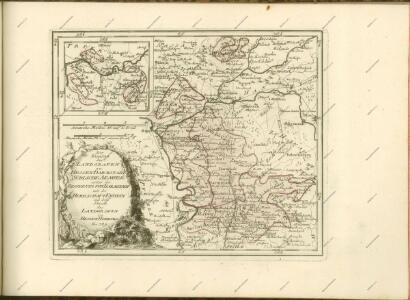
Situations Karte von Darmstadt und den umliegenden Gegenden zwischen Rhein, Mayn, Neckar &c.
Bechstatt, I. C.
Novam Hanc Territorii Francofurtensis Tabulam [...] [Karte], in: Le théâtre du monde, ou, Nouvel atlas contenant les chartes et descriptions de tous les païs de la terre, Bd. 1, S. 181.
1 Karte aus Atlas Blaeu, Willem Janszoon und Blaeu, Joan Blaeu, Willem Janszoon
Novam Hanc Territorii Francofurtensis Tabulam [Karte], in: Novus Atlas, das ist, Weltbeschreibung, Bd. 1, S. 150.
1 Karte aus Atlas Blaeu, Joan Blaeu, Willem Janszoon
Special Carte Des Rheinlaufes Von Speier Bis Bingen
Dewarat, Peter; Verhelst, Aegid Schwan und Götz
Strategische Situation am: 26. Juni, 4. Juli (Abends), 10. Juli (9 Uhr Morgens), 14. Juli Machmittags nach dem Gefecht von Aschaffenburg, 21. Juli, 26. Juli (Morges)
Hesensko (Německo)
Topographische Karte des Frankfurter Gebietes mit der Umgegend bis Mainz, Idstein, Friedberg, Aschaffenburg u. Darmstadt
1 : 100000 Frankfurt nad Mohanem (Německo) Ravenstein, August Dondorf August Ravenstein
Karte über das Überschwemmungsgebiet des Hochwassers im Winter 1882/83 längs des Main- und Rheinstromes in dem Großherzogthum Hessen
1 : 100000 Hessen-Darmstadt, Großherzogliche Landescultur-Inspection Bergsträsser
Territorium Francofurtense [Karte], in: Gerardi Mercatoris et I. Hondii Newer Atlas, oder, Grosses Weltbuch, Bd. 1, S. 218.
1 Karte aus Atlas Mercator, Gerhard und Hondius, Jodocus Jansson, Jan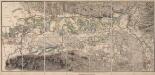
[Topographische Charte der Gegend zwischen Rhein, Neckar und Mayn]
Meister, G.
[Brouillon der Umgebung von Darmstadt]
Haas, Johann Heinrich; Lyncker, Ludwig; Meister, G.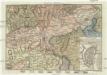
Gegend von Maynz
Mohuč (Německo) Engelmann, J. W. bey J.G. Oehler Buchdruck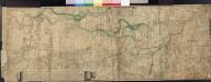
Le Cours Du Rhin Depuis Spire juisqu'à Mayence, les marches et Contremarches de l'Armée Francoise et les Camps y sont marqués Come aussi de l'Armée Alliée du coté du Main l'ann 1743 avec la Situation de l'Odewwald et du Berg Straass
Denis, Ferdinand
Die Umgebung von Homburg = The environs of Homburg
1 : 75000 gez[eichnet] von Fritz Schick Bad Homburg : Louis Schick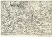
Maintz.
1 : 240000 Mollova mapová sbírka Person, Nikolaus Person, Nicolas
Das Rhein-Weinland
1 : 206000 Mohuč-oblast (Německo) Hellrung, Carl Ludwig Baensch, E. Rubach'schen Buchhandlung
Abbildung der Weit-Berühmten Keyserlichen- Frey- Reychs- Wahl- und Handel- Stat Franckfurt am Mayn mit ihrem Gebiet
1 : 130000 Mollova mapová sbírka Visscher, Nicolaes Jansz. Visscher, Nicolaus
Novam Hanc Territorii Francofvrtensis
1 : 85000 Mollova mapová sbírka Blaeu, Cornelius Blaeu, Cornelis
Territorium Francofurtense [Karte], in: Novus atlas absolutissimus, Bd. 2, S. 183.
1 Karte aus Atlas Janssonius Offizin
Le Flambeau de la Guerre Allumee au Rhin
Mollova mapová sbírka Delisle, Guillaume Schenk, Peter II
Territorium Sac. Rom. Imp. Lib. Civitatis Francofurti ad Moenum
1 : 65000 Mollova mapová sbírka Seutter, Matthäus Lotter, Tobias Conrad Seutter, Matthäus
Territorivm Francofvrtense
1 : 85000 Mollova mapová sbírka Valk, Gerhard Schenk, Peter II
Territorivm Francofvrtense
1 : 85000 Mollova mapová sbírka Janssonius, Johannes Janssonius, Johannes I
Novam Hanc TERRITORII FRANCOFVRTENSIS Tabulam...
[Amsterdam : Joan Blaeu]
Abbildung der Keysrl. Freyen- Reichs- Wahl. und Handelstatt Franckfurt am Mayn mit ihrem Gebiet umd Gräntzen vorgestlt von Ioh. Bapt. Homann in Nürnberg
1 : 100000 Mollova mapová sbírka Homann, Johann Baptist Homann, Johann Baptista - dědici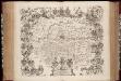
Novam hanc territorii Francofvrtensis tabulam / ... d.d.d. Johan. et Cornel. Blaeu
1 : 150000 Annotatie: Omringd door wapenschilden van magistraten uit Frankfurt aan de Main; Origineel is Blad 107 in atlas factice; Annotatie geografische gegevens: Met schaalstok Joan Blaeu 1597/98-1673; Cornelis Blaeu ca. 1610-1645 [Amsterdam : Joh. & Cornelius Blaeu]