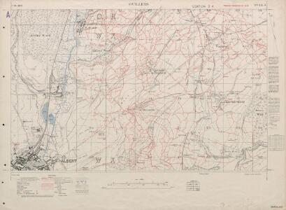
Maps of Ovillers-la-Boisselle
Trench Maps of the Battle Front in France and Belgium, Ovillers
Trench Maps [of the Battle Front in France and Belgium, showing trenches, wire entanglement, etc. With a Glossary printed on the back of the sheets]. Scale, 1: 10,000.
Trench Maps of the Battle Front in France and Belgium, Gruigies (SE)
[Trench Maps of the Battle Front in] Belgium and parts of France. Scale, 1: 20,000. Shows trenches, wire entanglement, etc. With a Glossary printed on the back of the sheets. [London] : [Geographical Section, General Staff].
Albert. Scale, 1: 40,000. First edition
Albert. Scale, 1: 40,000. First edition. [London] : [Geographical Section, General Staff]
Map showing front lines around Bapaume, France, in 1916 Fron Line 1916
1 : 885000 Fron Line 1916 H. & C. Graham Ltd. Lithrs. London : Stanford's Geogl. Estabt.
Map of the Somme Front.
1 : 40000 First World War map of the Somme Front. Advances between July 1st 1916 and 28th Feb 1917. War Office
Carte du gouuernement de Bappaume
1 Karte : Kupferdruck ; 11 x 15 cm s.n.
Map of the Somme area. Dec. 1916.
1 : 40000 First World War map of the Somme area. Dec.1916. Same map with Japanse characters at Maps 17535(3) and Russian at Maps 17535(4). War Office
Map of the Somme area.
1 : 40000 First World War map showing progress in Arras area. December 1916. War Office
Somme Front 1916: Allied lines in Oct. and Nov.
1 : 40000 First World War map of the Somme Front. Allied lines in Oct. and Nov. 1916. War Office
Battle of the Somme: July 1916
1 : 80000 Battle of the Somme. Situation in July 1916. War Office
Battle of the Somme: August 1916
1 : 80000 Battle of the Somme. Situation in August, 1916. War Office
Das Kampfgebiet an der Somme
1 : 200000 Somme, řeka (Francie) Velhagen & Klasing
Carte Particuliere des Environs de Cambray, Bappaumes, St. Quentin, Perone
1 : 116600 Mollova mapová sbírka Fricx, Eugène Henry Covens, Johannes I
Carte particuliere des environs de Cambray, Bappaumes, S. Quentin, Perone
1 : 116600 Mollova mapová sbírka Fricx, Eugène Henry Harrewyn, Jacques Fricx, Eugené Henry
Carte particuliere des environs de Cambray, Bappaumes, St. Quentin, Perone
1 : 110000 Bapaume (Francie) Fricx, Eugene Henry chez Eugene Henry Fricx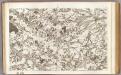
4 Abbeville.
1 : 86400 Cassini family; Cassini, Cesar-Francois, 1714-1784
Carte particuliere des environs de Cambray, Bappaumes, St. Quentin, Perone
1 : 115000 A Amsterdam : chez Cóvens et Mortier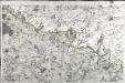
[Abbeville - Arras]
1 Blatt : 60 x 91 cm Le Roy s.n.
Carte particulière des environs de Cambray, Bappaumes, St. Quentin, Pérone
1 : 125000 A Bruxelles : ches Eugene Henry Fricx, ruë de la Madelene
Cambrai-Saint Quentin. Scale, 1 : 100,000 or 1 inch to 1.58 miles
Cambrai-Saint Quentin.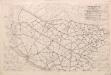
Third Army Traffic Map: June 1918
1 : 100000 First World War Third Army Traffic Map. June 1918. Overprinted on sheet 'Third Army administrative map'. Shows direction traffic must take, speed of vehicles, where not to take horses and mules. War Office
L'Archevesche de Cambray [Karte], in: Gerardi Mercatoris et I. Hondii Newer Atlas, oder, Grosses Weltbuch, Bd. 2, S. 26.
1 Karte aus Atlas Mercator, Gerhard und Hondius, Jodocus Jansson, Jan

Archiepiscopatus Cameracensis. Archevesché de Cambray. [Karte], in: Le théâtre du monde, ou, Nouvel atlas contenant les chartes et descriptions de tous les païs de la terre, Bd. 2, S. 26.
1 Karte aus Atlas Blaeu, Willem Janszoon und Blaeu, Joan Blaeu, Willem Janszoon
Archiepiscopatus Cameracensis. Archebesché de Cambray. [Karte], in: Novus Atlas, das ist, Weltbeschreibung, Bd. 2, S. 26.
1 Karte aus Atlas Blaeu, Joan Blaeu, Willem Janszoon
Veromandui
1 Karte : Kupferdruck ; 34 x 38 cm Sanson; Robert de Vaugondy; Cordier chés le Sr. Robert geog. du r. quai de l'Horloge
Artesia vulgo Artois, et Sedes Belli in Picardia &c Stoel des OOrlogs in Artois en Picardy, enz
1 : 250000 Mollova mapová sbírka Allard, Abraham Allart, Abraham
Ambiani
1 Karte : Kupferdruck ; 38 x 40 cm Sanson; Robert de Vaugondy; Cordier chez le Sr. Robert g. du r. quai de l'Horloge
Arras, Peronne, Noyon, uit: Le conflict mondial : front occidental
1 : 170000 Annotatie: Ontbreekt: no. 1 en 5-8 Gand : Th. de Graeve