Maps of Arras
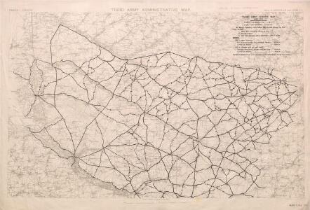
Third Army Traffic Map: June 1918
1 : 100000 First World War Third Army Traffic Map. June 1918. Overprinted on sheet 'Third Army administrative map'. Shows direction traffic must take, speed of vehicles, where not to take horses and mules. War Office
[Abbeville - Arras]
1 Blatt : 60 x 91 cm Le Roy s.n.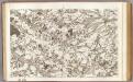
4 Abbeville.
1 : 86400 Cassini family; Cassini, Cesar-Francois, 1714-1784
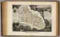
Ponthiev comitatvs
1 Karte : Kupferdruck ; 14 x 19 cm Lambert Andreae
Carte de la France. Abbeville (est), Feuille XVI-8
1 : 100000 Paris : Hachette
Les environs d'Abbeville, Dourlens, Amiens, Corbie, et du cours de la Somme
1 : 110000 Abbeville (Francie) Fricx, Eugene Henry Harrewyn, Jacques chez Eugene Henry Friex
Les environs d'Abbeville, Dourlens, Amiens, Corbie, et du Cours de la Sommme
1 : 116600 Mollova mapová sbírka Fricx, Eugène Henry Harrewyn, Jacques Fricx, Eugené Henry
Les environs d'Abbeville, Dourlens, Amiens, Corbie, et du Cours de la Somme
1 : 116600 Mollova mapová sbírka Fricx, Eugène Henry Covens, Johannes I
Carte du gouuernement de Hesdin
1 Karte : Kupferdruck ; 11 x 15 cm s.n.
Carte du gouuernem.t de Perne
1 Karte : Kupferdruck ; 11 x 15 cm s.n.
Carte Particuliere des Environs d'Arthois du Boulenois et d'une Partie de la Picardie
1 : 116600 Mollova mapová sbírka Fricx, Eugène Henry Covens, Johannes I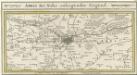
Arras Mitt Nahe anliegender Gegend
1 : 150000 Mollova mapová sbírka Bodenehr, Gabriel Bodenehr, Gabriel
Carte du gouuernement de St. Paul
1 Karte : Kupferdruck ; 11 x 15 cm s.n.
Trench Maps of the Battle Front in France and Belgium, Gruigies (SE)
[Trench Maps of the Battle Front in] Belgium and parts of France. Scale, 1: 20,000. Shows trenches, wire entanglement, etc. With a Glossary printed on the back of the sheets. [London] : [Geographical Section, General Staff].
PLAN DV SIEGE | DE HESDIN
[Amsterdam : Joan Blaeu]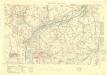
Trench Maps of the Battle Front in France and Belgium, Beaumont
Trench Maps [of the Battle Front in France and Belgium, showing trenches, wire entanglement, etc. With a Glossary printed on the back of the sheets]. Scale, 1: 10,000.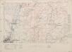
Trench Maps of the Battle Front in France and Belgium, Ovillers
Trench Maps [of the Battle Front in France and Belgium, showing trenches, wire entanglement, etc. With a Glossary printed on the back of the sheets]. Scale, 1: 10,000.
Le plan de Hesdin: ville forte du Comté d'Artois sur la riviere du Canche
1 : 8400 B. v. Zyl fecit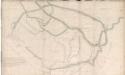
An outline plan of Abbeville
An outline plan of the town of Abbeville in France; drawn about 1630, on a scale of 37 toises to an inch.
HESDINVM
[Amsterdam : Joan Blaeu]
ATREBATVM, | Gallis ARRAS, | Belgis ATRECHT dicta
[Amsterdam : Joan Blaeu]
Plan de la ville et citadelle d'Arras: place forte Evêché capitalle du Comté d'Artois située sur la petite Piviere d'Escarpe
1 : 8650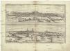
Montes, Hannoniae metropolis
Arras (Francie) Braun, Georg Hogenberg, Franz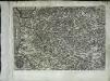
Artesia
1 Karte : Kupferdruck ; 21 x 30 cm Quad; Bussemacher Johannes Bussemacher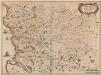
Descriptio Boloniae Pontieu Comit. S. Pauli Cum adiacentibus [Karte], in: Novus atlas absolutissimus, Bd. 4, S. 56.
1 Karte aus Atlas Janssonius Offizin
Département de la Somme
1 Karte : Kupferdruck ; 49 x 48 cm Houdan au bureau de l'Atlas nation.le de France rue de la Monnoye no. 5
Artesia
1 : 790000 Artois (Francie) Seutter, Matthäus Delisle, Guillaume â Matthaeo Seutter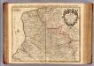
Artois, environs.
1 : 210000 L'Isle, Guillaume de, 1675-1726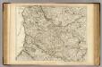
Artois, environs.
1 : 210000 L'Isle, Guillaume de, 1675-1726