Maps of Brentwood

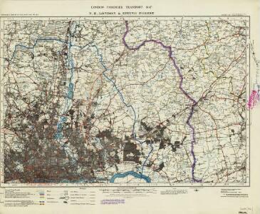
London passenger transport map
Ordnance Survey
Ordnance Survey of England and Wales (Sheet 7), South Wales
Ordnance Survey, Great Britain
Romford (Outline) - OS One-Inch Revised New Series
1 : 63360 Topographic maps Ordnance Survey Ordnance Survey
Romford (Hills) - OS One-Inch Revised New Series
1 : 63360 Topographic maps Ordnance Survey Ordnance Survey
Ordnance Survey of England. Sheet 257, Romford
1 : 63360 Ordnance survey. GB Southampton : Ordnance Survey Office
Enfield
Triangulation lines radiating from fixed points are clearly visible on this map. A pecked red line running adjacent to Lee River marks the boundary separating Essex from Hertforshire and Middlesex. Henhault Forest is shown by a stippled canopy of tree tops at the centre of the drawing. Perhaps the most interesting detail on this map is just south of the forest: a small drawing of a tree inside an enclosure marked 'Fairlop Oak'. This giant oak tree was something of a local landmark. In 1791, William Forsyth, gardener to George III, made unsuccessful attempts to halt the tree's decline. The year that this map was published, the tree was badly burnt by a fire started during a picnic. Its health steadily continued to wane until it was blown down in a gale in 1820. The inclusion of details such as the Fairlop Oak reveals the meticulous nature of the Survey, and the great attention paid to local detail. Budgen, Charles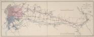
Map of the New River from its Source near the Town of Ware to London
Map of the course of the New River, a man made water course which has supplied London with fresh water from Hertfordshire since 1613. Commissioned by the House of Commons, the map features title and scale bar at top right and key to colour at bottom right. Telford, Thomas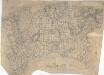
Dagenham
1 : 21120 This rough field sketch, or 'foul' copy, was produced on several pieces of irregularly cut paper joined together and laid on the verso of the triangulation map for southern England. Covering the north side of the Thames, East Ham and Ilford are to the left, and Rainham to the right. The drawing is dominated by a patchwork of field boundaries, with open dotting indicating unproductive enclosed land. The detail recorded here was incorporated in the 'fair' map OSD 132, titled 'Barking'.
TQ59 - OS 1:25,000 Provisional Series Map
1 : 25000 Topographic maps Ordnance Survey Ordnance Survey
TQ58 - OS 1:25,000 Provisional Series Map
1 : 25000 Topographic maps Ordnance Survey Ordnance Survey
TQ49 - OS 1:25,000 Provisional Series Map
1 : 25000 Topographic maps Ordnance Survey Ordnance Survey
TQ48 - OS 1:25,000 Provisional Series Map
1 : 25000 Topographic maps Ordnance Survey Ordnance Survey
TQ39 - OS 1:25,000 Provisional Series Map
1 : 25000 Topographic maps Ordnance Survey Ordnance Survey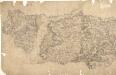
Epping
Pencil lines radiating from trigonometrical stations cover this drawing. They show the angles used for measuring distances and plotting topographical features. To the left of the map on Chestnut Common, the word 'flag' denotes the site of such a station. Hoddesden Park Wood and surrounding woodland are shown by individual trees with a line at the base, indicating shadow. This laborious technique was often replaced by a more generalised, stippled representation of treetops. The Lee River, running from Standstead at the top of this drawing, branches to form a canal leading down to the Powder Mills, which manufactured Gun Powder for shipping to London. Locks on the canal are shown in red
TQ38 - OS 1:25,000 Provisional Series Map
1 : 25000 Topographic maps Ordnance Survey Ordnance Survey
TL50 - OS 1:25,000 Provisional Series Map
1 : 25000 Topographic maps Ordnance Survey Ordnance Survey
Barking, Essex
1 : 21120 This plan of the north side of the Thames shows Barking and Ilford to the left, on the banks of the Roding, and Rainhham and Hornchurch to the right. A patchwork of field boundaries dominate the landscape, with open dotting depicting unproductive enclosed land. Pencil lines intersect across the plan, recording the angular measurements taken by the surveyor to calculate the distances between fixed points in the landscape.
TL40 - OS 1:25,000 Provisional Series Map
1 : 25000 Topographic maps Ordnance Survey Ordnance Survey
TQ68 - OS 1:25,000 Provisional Series Map
1 : 25000 Topographic maps Ordnance Survey Ordnance Survey
TL30 - OS 1:25,000 Provisional Series Map
1 : 25000 Topographic maps Ordnance Survey Ordnance Survey
Stratford - Le - Bow
1 : 21120 This plan of north east London extends from the Isle of Dogs and Wapping at the bottom, to 'Layton Stone' and Epping Forest at the top. Field boundaries infilled with stripes depict tilled land. Major settlements are drawn in red ink. North of Stoke Newington, to the top left, a road is plotted as a series of fixed points pricked off with dividers and joined by ruled pencil lines. These protractions were made directly from the Ordnance Survey field books. Pencil rays intersect across the map, evidence of measurements taken by the surveyor between fixed triangulation points. Poplar Gut is outlined in red at the Isle of Dogs, the beginnings of the development of the West India Docks.
TQ69 - OS 1:25,000 Provisional Series Map
1 : 25000 Topographic maps Ordnance Survey Ordnance Survey
TL60 - OS 1:25,000 Provisional Series Map
1 : 25000 Topographic maps Ordnance Survey Ordnance Survey
Plan of the roads and main objects on the eastern part of London : as connected with the tunnel excavating under the Thames from Rotherhithe to Wapping
1 : 48000 Brunel, Marc Isambard, Sir, 1769-1849 H. Teape & Son
Carte topographique de le comté de Middlesex, 2
1 Blatt : 53 x 73 cm John Rocque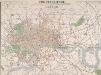
THE CIRCUITEER. A SERIES OF DISTANCE MAPS FOR ALL THE PRINCIPAL TOWNS IN THE UNITED KINGDOM. INVENTED BY J. FREDERICHS AS A GUIDE FOR ASCERTAINING CAB FARES, PORTERAGE &c. &c.
The title of this map of Victorian London appears at top centre, with a scale bar at the foot of the plate. The map is divided into circles, each a half-mile in diameter, allowing the reader to ascertain the distance between two places at a glance. Each circle is also numbered for reference, with a key to the principal streets and squares a in panel below the map, together with an explanatory note. Repeated in French and German, this note reports London cab fares, set by Act of Parliament at 8d (pence) per mile and 4d for every additional half mile. Frederichs, J.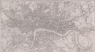
LONDON 1849 DRAWN & ENGRAVED EXPRESSLY FOR THE POST OFFICE DIRECTORY
This map has been engraved for the Post Office Directory. It is the third edition of a map originally published in 1847. Davis, Benjamin Rees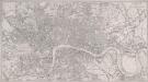
LONDON 269
This map of Victorian London was produced for publication in the Post Office Directory of 1852. The map's title and imprint appear at top right. It shows the entire London railway system. With the exception of Blackfriars and Marylebone stations, all London termini were built in the between 1736and 1876. As the railway companies scrambled to buy land to redevelop central London, many people, mainly slum-dwellers, were left homeless or forced to move to outer suburbs like Tottenham and Edmonton. Davies, Benjamin Rees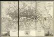
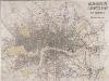
Map of London from an Actual Survey
Map of London printed in six sheets from a survey made during the period 1824-26.The map featurestitle and imprint at top right, dedication to King George IV at bottom centre, view of Westminster Abbeywith key to symbols at bottom left and view of St Paul's Cathedral with key to lines at bottom right. Greenwood, Christopher and John