Maps of Pontic Steppe

Tabula Asiae II. [Karte], in: Geographia universalis vetus et nova complectens Claudii Ptolemaei Alexandrini enarrationis libros VIII, S. 269.
1 Karte aus Atlas Münster, Sebastian [und Ptolemaeus, Claudius]
Dacia Or., Sarmatia, Caucasus, Scythia Int. Imaum / J.E. Knittel sculps
1 : 5100000 1 Karte : Kupferdruck ; 45 x 58 cm Campe, Friedrich Campius
Secunda Asie Tabula [Karte], in: [Clavdii Ptholomei Cosmographi ...], S. 302.
1 Karte aus Atlas Nicolaus Germanus [und Ptolemaeus, Claudius]
Sarmatia.
1 : 22000000 Fenner, Rest.
Anbau u. Juli-Jsothermen
Russland / Europäischer Teil Pflanzenbau, Klima
Russland von der Besiegung der Petschenegen durch die Polowzer und der Erweiterung der Nowgorodischen Republik nach Nordosten, um 1114 bis zur Zerstörung Kiew's durch die Tataren 1240
1 : 12000000 Weliki Nowgorod, Kiewer Reich
Schiffbare Flüsse u. Kanäle
Russland / Europäischer Teil Wasserstraße
Das europæische Russland nach seiner allmähligen Vergrösserung seit 1462
1 : 38500000 Russland / Europäischer Teil Expansion
Karte des Europaeischen Russlands
Neuester Schul-Atlas Walch, Johann im Verlag bei Joh. Walch
Karta želěznych dorog Rossijskoj imperiji
1 : 1200000 Moskva-oblast (Rusko) izdanije Kartografičeskago zavedenija A. Il'jina
Map illustrating ancient Russian history
Russland Kiewer Reich Philip, George ; Philip, [Sohn v. G.]
[Secunda Asie tabula] [Karte], in: Clavdii Ptholomei Viri Alexandrini Cosmographie, S. 167.
1 Karte aus Atlas Nicolaus Germanus [und Ptolemaeus, Claudius]
Ruszland, Regenmenge u. Januar-Jsothermen
Russland / Europäischer Teil Pflanzenbau, Klima
Nord- und Ost-Europa bis zur letzten Theilung Polens 1795
1 : 14000000 Nordeuropa, Osteuropa, Teilungen Polens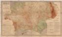
Gipsometričeskaja karta Jevropejskoj Rossii
1 : 2500000 Rusko západní Tillo, Alexis Kartografičeskoje zavedenije A. Il'jina
Europäisches Russland 1801-1855
1 : 15500000 Russland / Europäischer Teil
Das europaeische Russland
1 : 6588000 Rusko západní Weiland, Karl Ferdinand im Verlage des Geogr. Instituts
Secunda Asiae Tabula [Karte], in: Claudii Ptolemei viri Alexandrini mathematice discipline philosophi doctissimi geographie opus [...], S. 196.
1 Karte aus Atlas Waldseemüller, Martin [und Ptolemaeus, Claudius] Übelin, Georg
Mineralien
Russland / Europäischer Teil Mineralischer Rohstoff
Russland von der Verlegung des Russischen Grossfürstenthums nach Moskau, 1328, und der Gründung des Grossfürstenthums Litthauen bis zur Vernichtung der Goldenen Horde, 1480
1 : 12000000 Großfürstentum Litauen, Moskauer Reich
Die allmähliche Bildung des Russischen Reiches vom Untergang des Freistaates Nowgorod 1478 bis zum Jahre 1715
Rusko Gindely, Antonín F. Tempsky
Die allmähliche Bildung des Russischen Reiches vom Untergang des Freistaates Nowgorod 1478 bis zum Jahre 1715
Rusko západní Gindely, Antonín F. Tempsky
Karta rossijskich želěznych dorog
1 : 5250000 Charkov-oblast (Ukrajina) Bangof, Eduard v artističeskom zavedenija A.F. Marksa
Charte von dem europaischen Russland
1 : 9400000 Rusko západní Streit, Friedrich Wilhelm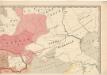
Evropa raného středověku: do konce VI. století po Kr.
Kašpar, Jan
Russisches Reich. Verwaltungsgrenzen von 1914. Europäischer Teil
Russland / Europäischer Teil Verwaltungsgliederung
Russie d'Europe
1 Blatt : 62 x 93 cm Semen etc
Russia & Poland.
1 : 5639040 Arrowsmith, John
Russia.
1 : 10000000 Colton, G.W.
![Tabula Asiae II. [Karte], in: Geographia universalis vetus et nova complectens Claudii Ptolemaei Alexandrini enarrationis libros VIII, S. 269.](https://images-0.georeferencer.com/images/iiif/283289468058/full/,300/0/native.jpg)

