Maps of Pontic Steppe

[Secunda Asie tabula] [Karte], in: Clavdii Ptholomei Viri Alexandrini Cosmographie, S. 167.
1 Karte aus Atlas Nicolaus Germanus [und Ptolemaeus, Claudius]
Standorte der höheren Kommandos in Europa und Kaukasus
Russland Russland / Europäischer Teil Kaukasus Militär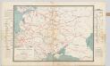
Spoorwegkaart van Rusland / naar de nieuwste bronnen vervaardigd door J. Pik
1 : 2500000 Annotatie: Met informatie over Russische spoorwegmaatschappijen en over het Russische geld; Annotatie geografische gegevens: Met drie maatstokken: Duitsche mijlen, Kilometers en Wersten J. Pik Groningen : De Financier
[Neuer Atlas der ganzen Erde nach den neuesten Bestimmungen ... : XXII.] Charte von dem Europaeisch-Russischen Reiche
Entworfen u. gezeichnet von Dr. F.W. Streit H. Leutemann sc. Leipzig : J.C. Hinrichssche Buchhandlung
Anbau u. Juli-Jsothermen
Russland / Europäischer Teil Pflanzenbau, Klima
Uebersicht über die Stabsquartiere der russischen Armee
Russland Militär
Map illustrating ancient Russian history
Russland Kiewer Reich Philip, George ; Philip, [Sohn v. G.]
Ruszland, Regenmenge u. Januar-Jsothermen
Russland / Europäischer Teil Pflanzenbau, Klima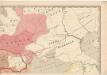
Evropa raného středověku: do konce VI. století po Kr.
Kašpar, Jan
Das Europaeische Russland
Russland / Europäischer Teil
Das europæische Russland nach seiner allmähligen Vergrösserung seit 1462
1 : 38500000 Russland / Europäischer Teil Expansion
Das europaeische Russland
1 : 6500000 entworfen von C.F. Weiland C.J. Maedel sen. sc. Weimar : im Verlage des Geographischen Instituts
Dacia Or., Sarmatia, Caucasus, Scythia Int. Imaum / J.E. Knittel sculps
1 : 5100000 1 Karte : Kupferdruck ; 45 x 58 cm Campe, Friedrich Campius
Karta rossijskich želěznych dorog
1 : 5250000 Charkov-oblast (Ukrajina) Bangof, Eduard v artističeskom zavedenija A.F. Marksa
Composite: Das Russische Reich in Europa.
1 : 4475000 Stein, Christ. Gottfr. Dan.
Nord- und Ost-Europa bis zur letzten Theilung Polens 1795
1 : 14000000 Nordeuropa, Osteuropa, Teilungen Polens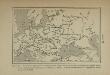
Carte de la répartition des langues slaves d’après les quatre groupes principaux de peuples slaves […]
Europa Slawische Sprachen
Carte de la partie européenne de l'empire de Russie, avec l'indication des chemins de poste, ainsi que des douanes frontières et de la repartition actuelle en gouvernements et districts
1 : 3000000
Russie d'Europe.
1 : 11000000 Monin, C.V.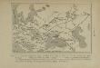
Carte des peuplements slaves, au début du 5e siècle de notre ère, lors des invasions des Huns
Ostmitteleuropa Slawen Bevölkerung Hunnen
Europäisches Russland 1801-1855
1 : 15500000 Russland / Europäischer Teil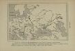
Carte des peuplements slaves au 6e siècle de notre ère, selon Jordanes
Ostmitteleuropa Slawen Bevölkerung Völkerwanderungszeit Jordanides
Secunda Asie Tabula [Karte], in: [Clavdii Ptholomei Cosmographi ...], S. 302.
1 Karte aus Atlas Nicolaus Germanus [und Ptolemaeus, Claudius]
Schiffbare Flüsse u. Kanäle
Russland / Europäischer Teil Wasserstraße
Mineralien
Russland / Europäischer Teil Mineralischer Rohstoff
Russisches Reich. Verwaltungsgrenzen von 1914. Europäischer Teil
Russland / Europäischer Teil Verwaltungsgliederung
Verbreitung der Slaven um 1900
Osteuropa Slawen Anton, J.
Karta želěznych dorog Rossijskoj imperiji
1 : 1200000 Moskva-oblast (Rusko) izdanije Kartografičeskago zavedenija A. Il'jina
Russia, Poland.
1 : 5702400 Stanford, Edward
Die allmähliche Bildung des Russischen Reiches vom Untergang des Freistaates Nowgorod 1478 bis zum Jahre 1715
Rusko Gindely, Antonín F. Tempsky
![[Secunda Asie tabula] [Karte], in: Clavdii Ptholomei Viri Alexandrini Cosmographie, S. 167.](https://images-2.georeferencer.com/images/iiif/362882813079/full/,300/0/native.jpg)

