Maps of Pontic Steppe
Evropa raného středověku: do konce VI. století po Kr.
Kašpar, Jan
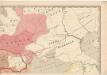
Spoorwegkaart van Rusland / naar de nieuwste bronnen vervaardigd door J. Pik
1 : 2500000 Annotatie: Met informatie over Russische spoorwegmaatschappijen en over het Russische geld; Annotatie geografische gegevens: Met drie maatstokken: Duitsche mijlen, Kilometers en Wersten J. Pik Groningen : De Financier
Karta rossijskich želěznych dorog
1 : 5250000 Charkov-oblast (Ukrajina) Bangof, Eduard v artističeskom zavedenija A.F. Marksa
Des europäischen Russlands südlicher Theil
Allgemeiner Atlas [Walch, Johannes] im Verlag bei Johannes Walch
Das europæische Russland nach seiner allmähligen Vergrösserung seit 1462
1 : 38500000 Russland / Europäischer Teil Expansion
[Secunda Asie tabula] [Karte], in: Clavdii Ptholomei Viri Alexandrini Cosmographie, S. 167.
1 Karte aus Atlas Nicolaus Germanus [und Ptolemaeus, Claudius]
Standorte der höheren Kommandos in Europa und Kaukasus
Russland Russland / Europäischer Teil Kaukasus Militär
Ruszland, Regenmenge u. Januar-Jsothermen
Russland / Europäischer Teil Pflanzenbau, Klima
Russisches Reich. Verwaltungsgrenzen von 1914. Europäischer Teil
Russland / Europäischer Teil Verwaltungsgliederung
Europäisches Russland
1 : 14500000 Russland / Europäischer Teil
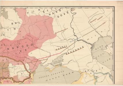
Carte des peuplements slaves, au début du 5e siècle de notre ère, lors des invasions des Huns
Ostmitteleuropa Slawen Bevölkerung Hunnen
Europäisches Russland 1801-1855
1 : 15500000 Russland / Europäischer Teil
Geologische Übersicht
Russland / Europäischer Teil Geologie
Europäisches Russland

Uebersicht über die Stabsquartiere der russischen Armee
Russland Militär
Carte de la partie européenne de l'empire de Russie, avec l'indication des chemins de poste, ainsi que des douanes frontières et de la repartition actuelle en gouvernements et districts
1 : 3000000
Das Europaeische Russland
Russland / Europäischer Teil
Mineralien
Russland / Europäischer Teil Mineralischer Rohstoff
E. Russland
Rusko západní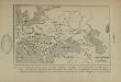
Carte des établissements nouveaux c’e peuples en Europe vers le milieu du 7e siècle (an 634 à 669), à la suite de l’affaiblissement du royaume des Avars, de la répartition nouvelle des Slaves, de l’agrandissement des Bulgares et de la formation du royaume des Khazars
Europa Völkerwanderung
Charte des europäischen Russlands
Russland / Europäischer Teil
Dacia Or., Sarmatia, Caucasus, Scythia Int. Imaum / J.E. Knittel sculps
1 : 5100000 1 Karte : Kupferdruck ; 45 x 58 cm Campe, Friedrich Campius
Map illustrating ancient Russian history
Russland Kiewer Reich Philip, George ; Philip, [Sohn v. G.]
Anbau u. Juli-Jsothermen
Russland / Europäischer Teil Pflanzenbau, Klima
Sovětský svaz v mapách

Europäisches Russland
Russland / Europäischer Teil Skizzenbuch
Europäisches Russland
1 : 5000000 Rusko západní Handtke, Friedrich Carl Flemming, Verlag, Buch- und Kunstdruckerei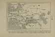
Carte approximative du royaume des Avars, lors de leur apogee (an 620 à 630 de notre ère) avec leur rayon d’action (peoples soumis, tributaires ou allies), montrant la repartition des divers peoples établis en Europe et jusqu’aux confins de l’Asie, à l’epoque de l’empereur Héraclius
Ungarn Awaren
Völkerkarte der Sowjet-Union
1 : 5000000 Sovětský svaz Klante, M. Leibbrandt, Georg Verlagsanstalt Otto Stollberg