Maps of Balkan Pen.
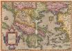
Graeciae Universae Secundum Hodiernum Situm Neoterica Descriptio. [Karte], in: Theatrum orbis terrarum, S. 252.
1 Karte aus Atlas Ortelius, Abraham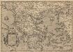
Graeciae Universae Secundum Hodiernum Situm Neoterica Descriptio. [Karte], in: Theatrum orbis terrarum, S. 347.
1 Karte aus Atlas Ortelius, Abraham Vrients, Jan Baptista
Turecká říše w Ewropé, Řecko, Jonické ostrowy
1 : 6500000 Jónské ostrovy (Řecko) Merklas, Václav
Graecia. [Karte], in: Novus Atlas, das ist, Weltbeschreibung, Bd. 3, S. 332.
1 Karte aus Atlas Blaeu, Joan Blaeu, Willem Janszoon
Tableau historique de la Grece.
1 : 5500000 Duval, Henri
Nova Totius Graeciae descriptio. [Karte], in: Novus atlas absolutissimus, Bd. 5, S. 274.
1 Karte aus Atlas Janssonius Offizin
Graecia [Karte], in: Gerardi Mercatoris Atlas, sive, Cosmographicae meditationes de fabrica mundi et fabricati figura, S. 484.
1 Karte aus Atlas Mercator, Gerhard Montanus, Petrus
99-100. Balkan Peninsula, Aegean Sea. The World Atlas.
1 : 2500000 USSR (Union of Soviet Socialist Republics).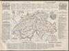
Graecia. [Karte], in: Le théâtre du monde, ou, Nouvel atlas contenant les chartes et descriptions de tous les païs de la terre, Bd. 3, S. 290.
1 Karte aus Atlas Blaeu, Willem Janszoon und Blaeu, Joan Blaeu, Willem Janszoon
Turkey In Europe.
1 : 10700000 Mitchell, Samuel Augustus
Anbau und Juli-Isothermen
Balkanhalbinsel Pflanzenbau, Klima
Der Europäische Theil des Osmanischen Reichs oder die Europäische Türkey
Stieler's Hand-Atlas Stieler, Adolf bei Justus Perthes
Türkei und Griechenland.
1 : 5000000 Osmanisches Reich / Europäischer Teil, Griechenland
Das Osmanische Reich in Europa, Griechenland und die Jonischen Inseln
Schul-Atlas über alle Theile der Erde nach dem neuesten Zustande, und über das Weltgebäude Stieler, Adolf Justus Perthes
Graecia. [Karte], in: Theatrum orbis terrarum, sive, Atlas novus, Bd. 3, S. 282.
1 Karte aus Atlas Blaeu, Joan Blaeu, Willem Janszoon
Die Europaeische Türkei, Griechenland und die Jonischen Inseln
E. von Sydow's Schul-Atlas in sechs und dreissig Karten Sydow, Emil von bei Justus Perthes
Die Europäische Türkey, Griechenland und die Jonischen Inseln
Schul-Atlas über alle Theile der Erde nach dem neuesten Zustande, und über das Weltgebäude Stieler, Adolf bei Justus Perthes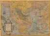
Graeciae Universae Secundum Hodiernum Situm Neoterica Descriptio. [Karte], in: Theatrum orbis terrarum, S. 95.
1 Karte aus Atlas Ortelius, Abraham
Die EuropaeischeTuerkey, Griechenland und die Jonischen Inseln
Osmanisches Reich / Europäischer Teil, Griechenland
Tabula Europae X. [Karte], in: Claud. Ptolemaeus. Geographia lat. cum mappis [...], S. 281.
1 Karte aus Atlas Münster, Sebastian [und Ptolemaeus, Claudius]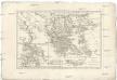
Graecia vetus
1 : 7900000 Řecko Bonne, Rigobert André
Balkan-Halbinsel, politische Übersicht
1 : 6000000 Balkanhalbinsel
Balkan-Halbinsel, Flusz- & Gebirgskarte
1 : 6000000 Balkanhalbinsel
Anbau und Januar-Isothermen
Balkanhalbinsel Pflanzenbau, Klima
Des Osmanischen Reichs europäischer Theil, Griechenland und die Jonischen Inseln
osmanská říše Stülpnagel, Friedrich von Jättnig, Karl Justus Perthes
The First Bulgarian Empire
Bulgarien Simeon I., Bulgarien, Zar, Samuil, Bulgarien, Zar
Graecia cum terris adjacentibus
Griechenland
Jeviště východní otázky.
Evropa jihovýchodní Berthe, L. Karl Wilhelm Ferdinand Brunšvický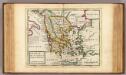
Greece or the south part of Turky in Europe.
1 : 4700000 Moll, Herman, d. 1732
![Graeciae Universae Secundum Hodiernum Situm Neoterica Descriptio. [Karte], in: Theatrum orbis terrarum, S. 252.](https://images-2.georeferencer.com/images/iiif/798263107609/full/,300/0/native.jpg)

