Maps of Balkan Pen.

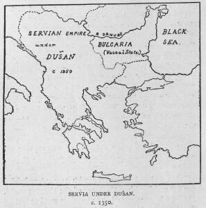
Servia under Dušan c. 1350
Serbien Stefan Dušan, Srbija, Car
The First Bulgarian Empire
Bulgarien Simeon I., Bulgarien, Zar, Samuil, Bulgarien, Zar
Völkerkarte
Südosteuropa Ethnische Gruppe
Des Osmanischen Reichs europäischer Theil, Griechenland und die Jonischen Inseln
osmanská říše Stülpnagel, Friedrich von Jättnig, Karl Justus Perthes
Des Osmanischen Reichs europäischer Theil, Griechenland und die Jonischen Inseln
Hand-Atlas über alle Theile der Erde nach dem neuesten Zustande und über das Weltgebäude Stieler, Adolf bei Justus Perthes
Des Osmanischen Reichs europäischer Theil, Griechenland und die Jonischen Inseln
Hand-Atlas über alle Theile der Erde nach dem neuesten Zustande und über das Weltgebäude Stieler, Adolf bei Justus Perthes

Bodenschätze und Industrie
Balkanhalbinsel Wirtschaft, Mineralischer Rohstoff
[Ethnographische Karte des Osmanischen Reichs europäischen Theils und von Griechenland]
Zweiter Band, enthaltend in vier Abtheilungen die Vertheilung der Organismen: 5. Pflanzen-Geographie, 6. Thier-Geographie, 7. Anthropographie, 8. Ethnographie Humboldt, Alexander von Verlag von Justus Perthes
Turquie d'Europe
1 : 2650000 par le Sr. Janvier, géographe A Vénice : par François Santini [...] chez M. Redini
Turquie.
1 : 3900000 Janvier, Jean
Die E. Türkei Griechenland und die Ionischen Inseln
Jónské ostrovy (Řecko)
Europaeische Türkey und Griechenland
1 : 4200000 Jónské ostrovy (Řecko) Theinert, A. Fleming, C. C. Fleming
Die Europaeische Türkei, Griechenland und die Ionischen Inseln
1 : 6000000 Balkanhalbinsel
Der europäische Theil des Türkischen Reichs
1 : 1680000 Evropa jihovýchodní Reichard, C. G. Campe, Friedrich Friedrich Campe
Turkey in Europe.
1 : 5860000 Tanner, Henry S.
Balkan-Halbinsel
Adolf Stieler's Handatlas über alle Theile der Erde und über das Weltgebäude Stieler, Adolf Justus Perthes
Turquie d'Europe
1 : 2500000 Turecko západní Janvier, Jean Denis Redine, M. Francois Santini
Balkanländer von 1878-1915
1 : 15000000 Balkanhalbinsel
Turkey in Europe.
1 : 5790000 Finley, Anthony

Balkan-Halbinsel
1 : 4500000 Balkanhalbinsel
Europäische Türkei von 1812-1878 (Berliner Kongreß)
1 : 15000000 Osmanisches Reich / Europäischer Teil Berliner Kongress
Ethnographische Karte des Osmanischen Reichs.
1 : 3800000 Berghaus, Heinrich
Hungary, European Turkey.
1 : 3100000 Playfair, Principal
Turkey In Europe.
1 : 5850000 Tanner, Henry S.
Turkey In Europe.
1 : 5850000 Tanner, Henry S.
Makedonische Frage: Gebietsansprüche ca. Anfang 1912
Makedonien Balkankrieg <1912-1913>, Territorialer Anspruch Zwick, J. ; Clewing, K.
Turkey in Europe.
1 : 3800000 Teesdale, Henry