Maps of Greece
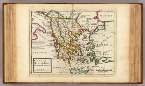
Greece or the south part of Turky in Europe.
1 : 4700000 Moll, Herman, d. 1732
Graecia. [Karte], in: Le théâtre du monde, ou, Nouvel atlas contenant les chartes et descriptions de tous les païs de la terre, Bd. 3, S. 290.
1 Karte aus Atlas Blaeu, Willem Janszoon und Blaeu, Joan Blaeu, Willem Janszoon
Graecia. [Karte], in: Theatrum orbis terrarum, sive, Atlas novus, Bd. 3, S. 282.
1 Karte aus Atlas Blaeu, Joan Blaeu, Willem Janszoon
Graecia [Karte], in: Gerardi Mercatoris Atlas, sive, Cosmographicae meditationes de fabrica mundi et fabricati figura, S. 484.
1 Karte aus Atlas Mercator, Gerhard Montanus, Petrus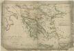
Atlas orbis antiqui totius secundum optimos scriptores ...

Graecia. [Karte], in: Novus Atlas, das ist, Weltbeschreibung, Bd. 3, S. 332.
1 Karte aus Atlas Blaeu, Joan Blaeu, Willem Janszoon
Graecia cum terris adjacentibus
Griechenland
GRÆCIA
Joh. et Corn. Blaeu exc.
99-100. Balkan Peninsula, Aegean Sea. The World Atlas.
1 : 2500000 USSR (Union of Soviet Socialist Republics).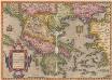
Graeciae Universae Secundum Hodiernum Situm Neoterica Descriptio. [Karte], in: Theatrum orbis terrarum, S. 252.
1 Karte aus Atlas Ortelius, Abraham
Nova Totius Graeciae descriptio. [Karte], in: Novus atlas absolutissimus, Bd. 5, S. 274.
1 Karte aus Atlas Janssonius Offizin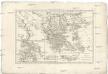
Graecia vetus
1 : 7900000 Řecko Bonne, Rigobert André
Turkey in Europe.
1 : 5860000 Tanner, Henry S.
Des Osmanischen Reichs europäischer Theil, Griechenland und die Jonischen Inseln
osmanská říše Stülpnagel, Friedrich von Jättnig, Karl Justus Perthes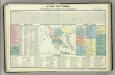
Tableau historique de la Grece.
1 : 5500000 Duval, Henri
The First Bulgarian Empire
Bulgarien Simeon I., Bulgarien, Zar, Samuil, Bulgarien, Zar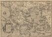
Graeciae Universae Secundum Hodiernum Situm Neoterica Descriptio. [Karte], in: Theatrum orbis terrarum, S. 347.
1 Karte aus Atlas Ortelius, Abraham Vrients, Jan Baptista
Servia under Dušan c. 1350
Serbien Stefan Dušan, Srbija, Car
Makedonische Frage: Gebietsansprüche ca. Anfang 1912
Makedonien Balkankrieg <1912-1913>, Territorialer Anspruch Zwick, J. ; Clewing, K.
[Ethnographische Karte des Osmanischen Reichs europäischen Theils und von Griechenland]
Zweiter Band, enthaltend in vier Abtheilungen die Vertheilung der Organismen: 5. Pflanzen-Geographie, 6. Thier-Geographie, 7. Anthropographie, 8. Ethnographie Humboldt, Alexander von Verlag von Justus Perthes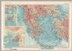
Albania, Greece. Pergamon World Atlas.
1 : 2500000 Polish Army Topography Service
Des Osmanischen Reichs europäischer Theil, Griechenland und die Jonischen Inseln
Hand-Atlas über alle Theile der Erde nach dem neuesten Zustande und über das Weltgebäude Stieler, Adolf bei Justus Perthes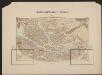
Graecia [Karte], in: Gerardi Mercatoris et I. Hondii Newer Atlas, oder, Grosses Weltbuch, Bd. 2, S. 327.
1 Karte aus Atlas Mercator, Gerhard und Hondius, Jodocus Jansson, Jan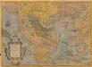
Graeciae Universae Secundum Hodiernum Situm Neoterica Descriptio. [Karte], in: Theatrum orbis terrarum, S. 95.
1 Karte aus Atlas Ortelius, Abraham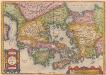
[Hellás], Graecia Sophiani. [Karte], in: Theatrum orbis terrarum, S. 404.
1 Karte aus Atlas Ortelius, Abraham
GRAECIAE et ARCHIPELAGI delineatio
Řecko
Des Osmanischen Reichs europäischer Theil, Griechenland und die Jonischen Inseln
Hand-Atlas über alle Theile der Erde nach dem neuesten Zustande und über das Weltgebäude Stieler, Adolf bei Justus Perthes
Nieuwe kaart des Zuiderdeels van 't Europisch Turkyen
1 : 7000000 [S.l.] : [s.n.]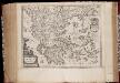
Graecia
1 : 2500000 Annotatie: Met opdracht door Joh. en Cornelius Blaeu aan Claudius Salmasius; Origineel is Blad 169 in atlas factice; Annotatie geografische gegevens: Met schaalstok Joan Blaeu 1597/98-1673; Cornelis Blaeu ca. 1610-1645 [Amsterdam : Joh. et Corn. Blaeu excudit]