Maps of Mediterranean Sea
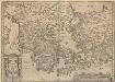
Graecia, Sophiani.[Karte], in: Theatrum orbis terrarum, S. 514.
1 Karte aus Atlas Ortelius, Abraham Vrients, Jan Baptista
Nova Graecia XXII. Nova Tabula. [Karte], in: Claud. Ptolemaeus. Geographia lat. cum mappis [...], S. 428.
1 Karte aus Atlas Münster, Sebastian [und Ptolemaeus, Claudius]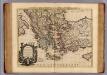
Carte de la Grece.
1 : 2500000 L'Isle, Guillaume de, 1675-1726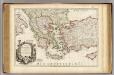
Carte de la Grece.
1 : 2500000 L'Isle, Guillaume de, 1675-1726
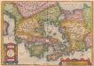
[Hellás], Graecia Sophiani. [Karte], in: Theatrum orbis terrarum, S. 404.
1 Karte aus Atlas Ortelius, Abraham
Schematičeska karta na M. Dehn
Balkanhalbinsel Grenze Balkankrieg <1912-1913> Kartogramm
Griechenland und die Länder der Balkan-Halbinsel
Plastischer Schul-Atlas über alle Theile der Erde : in 24 Karten Woldermann, G Verlag von P. Eckerlein
La Mediterranée, 2
1 Blatt : 53 x 63 cm Le Rouge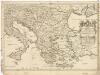
Estats de l'empire des Turqs en Europe
1 : 4270000 Evropa jihovýchodní Sanson, Guillaume Cordier, Louis chez H. Iaillot
Tabula Europae IX. [Karte], in: Claud. Ptolemaeus. Geographia lat. cum mappis [...], S. 278.
1 Karte aus Atlas Münster, Sebastian [und Ptolemaeus, Claudius]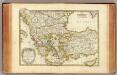
Turquie.
1 : 3900000 Janvier, Jean
Turquie d'Europe
1 : 2650000 par le Sr. Janvier, géographe A Vénice : par François Santini [...] chez M. Redini

Nieuwe kaart des Zuiderdeels van 't Europisch Turkyen
1 : 7000000 [S.l.] : [s.n.]
Griechenland, Kleinasien, Eroberung Konstantinopel's, 1453.
1 : 3800000 Spruner von Merz, Karl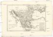
Turquie d'Europe
1 : 6960000 Balkánský poloostrov Bonne, Rigobert André
Balkan-Halbinsel
1 : 4500000 Balkanhalbinsel
Griechenland, Kleinasien XIten.-Mitte des XIIIten. Jhdts.
1 : 3800000 Spruner von Merz, Karl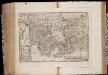
Ellas : Graecia, Sophiani / Abrahamo Ortelio descriptore
1 : 2500000 titelvariant: Graecia, Sophiani; Hellas; Annotatie: De kaart is uitgegeven in de periode 1597-1624; Cum priuilegio; Origineel is Blad 170 in atlas factice; Annotatie geografische gegevens: 4 schaalstokken: 1000 Stadia, en: 60 Mil. Germ., en: 70 Mil. Gall., en: 240 Mil. Ital [S.l. : Abraham Ortelius]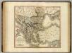
Turkey in Europe.
1 : 3450000 Cary, John, ca. 1754-1835
Carte de la Mer Méditerranée, 2
1 Blatt : 50 x 51 cm Froullé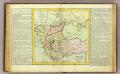
Turquie d'Europe.
1 : 6000000 Clouet, J. B. L. (Jean-Baptiste Louis), b. 1730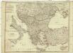
Karte von dem Oschmanischen Reiche in Europa
1 : 2800000 Balkánský poloostrov Anville, Jean-Baptiste Bourguinon d' Marco Berra
Karte von dem Oschmanischen Reiche in Europa
1 : 2800000 Balkánský poloostrov Reilly, Franz Johann Josef von Anville, Jean-Baptiste Bourguinon d' Franz Ioh. Ios. von Reilly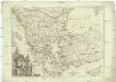
Turquie d'Europe
1 : 2500000 Turecko západní Janvier, Jean Denis Redine, M. Francois Santini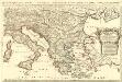
Estats de l'Empire des Turqs en Europe
1 : 3400000 Mollova mapová sbírka Sanson, Guillaume Jaillot, Alexis Hubert
La Turchia d'Europa
1 : 10000000 Evropa jihovýchodní
Völkerkarte
Südosteuropa Ethnische Gruppe
![Graecia, Sophiani.[Karte], in: Theatrum orbis terrarum, S. 514.](https://images-2.georeferencer.com/images/iiif/238409608310/full/,300/0/native.jpg)

