Maps of Balkan Pen.

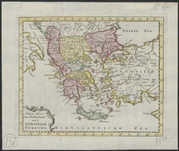
Nieuwe kaart des Zuiderdeels van 't Europisch Turkyen
1 : 7000000 [S.l.] : [s.n.]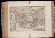
Ellas : Graecia, Sophiani / Abrahamo Ortelio descriptore
1 : 2500000 titelvariant: Graecia, Sophiani; Hellas; Annotatie: De kaart is uitgegeven in de periode 1597-1624; Cum priuilegio; Origineel is Blad 170 in atlas factice; Annotatie geografische gegevens: 4 schaalstokken: 1000 Stadia, en: 60 Mil. Germ., en: 70 Mil. Gall., en: 240 Mil. Ital [S.l. : Abraham Ortelius]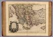
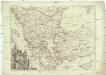
Carte de la Grece.
1 : 2500000 L'Isle, Guillaume de, 1675-1726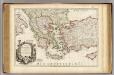
Carte de la Grece.
1 : 2500000 L'Isle, Guillaume de, 1675-1726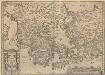
Graecia, Sophiani.[Karte], in: Theatrum orbis terrarum, S. 514.
1 Karte aus Atlas Ortelius, Abraham Vrients, Jan Baptista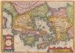
[Hellás], Graecia Sophiani. [Karte], in: Theatrum orbis terrarum, S. 404.
1 Karte aus Atlas Ortelius, Abraham
Balkan Peninsula.
1 : 3220177 Stanford, Edward
Nova Graecia XXII. Nova Tabula. [Karte], in: Claud. Ptolemaeus. Geographia lat. cum mappis [...], S. 428.
1 Karte aus Atlas Münster, Sebastian [und Ptolemaeus, Claudius]
Turquie d'Europe
1 : 2650000 par le Sr. Janvier, géographe A Vénice : par François Santini [...] chez M. Redini
Turquie d'Europe
1 : 2500000 Turecko západní Janvier, Jean Denis Redine, M. Francois Santini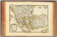
Turquie.
1 : 3900000 Janvier, Jean
Serbien und der Balkan aus der Vogelschau
Turquie.
1 : 9300000 Delamarche, Charles Francois; Lattre, Jean
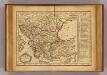
Balkan-Halbinsel
1 : 4500000 Balkanhalbinsel
Decima Et Ultima Tabula Europae [Karte], in: Claudii Ptolemei viri Alexandrini mathematice discipline philosophi doctissimi geographie opus [...], S. 178.
1 Karte aus Atlas Waldseemüller, Martin [und Ptolemaeus, Claudius] Übelin, Georg
Griechenland, Kleinasien, Eroberung Konstantinopel's, 1453.
1 : 3800000 Spruner von Merz, Karl
Turkey in Europe.
1 : 6200000 Darton, William
Griechenland, Kleinasien XIten.-Mitte des XIIIten. Jhdts.
1 : 3800000 Spruner von Merz, Karl
Turkey in Europe.
1 : 2750000 Robert Laurie & James Whittle
Staaten der Balkan-Halbinsel
Volksschul-Atlas über alle Teile der Erde Lange, Henry Druck und Verlag von Georg Westermann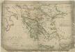
Atlas orbis antiqui totius secundum optimos scriptores ...
Geographie des temps heroiques de la Grece; Homere, Hesiode les argonautes.
Vivien de Saint-Martin, M.
Servia under Dušan c. 1350
Serbien Stefan Dušan, Srbija, Car
Tabula Europae X. [Karte], in: Claud. Ptolemaeus. Geographia lat. cum mappis [...], S. 281.
1 Karte aus Atlas Münster, Sebastian [und Ptolemaeus, Claudius]
Völkerkarte
Südosteuropa Ethnische Gruppe
The First Bulgarian Empire
Bulgarien Simeon I., Bulgarien, Zar, Samuil, Bulgarien, Zar
Die Balkan-Halbinsel
1 : 5500000 Balkanhalbinsel
Ethnographische Karte des Osmanischen Reichs.
1 : 3800000 Berghaus, Heinrich