Maps of Mediterranean Sea
Nova Graecia XXII. Nova Tabula. [Karte], in: Claud. Ptolemaeus. Geographia lat. cum mappis [...], S. 428.
1 Karte aus Atlas Münster, Sebastian [und Ptolemaeus, Claudius]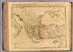
Orbis Romani descriptio.
1 : 3800000 L'Isle, Guillaume de, 1675-1726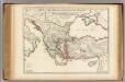
Orbis Romani descriptio.
1 : 3800000 L'Isle, Guillaume de, 1675-1726
La Mediterranée, 2
1 Blatt : 53 x 63 cm Le Rouge
Mare Mediterraneum, 2
1 Blatt : 47 x 58 cm G. und L. Valck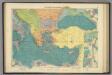
E. Mediterranean.
1 : 5000000 Philip, George
Pascaarte Van't Oostelyckste deel vande Middelandsche Zee [...] [Karte], in: Het vijfde Deel Des Grooten Atlas : Vervatende De Water-Weereld, S. 223.
1 Karte aus Atlas Jansson, Jan Jansson, Jan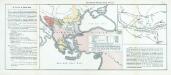
Nr. 15. Der russisch-türkische Krieg 1877/78
Balkanhalbinsel Russisch-Russisch-Türkischer Krieg <1877-1878>
Schematičeska karta na M. Dehn
Balkanhalbinsel Grenze Balkankrieg <1912-1913> Kartogramm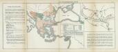
Nr. 11. Der russisch-türkische Krieg 1877/78
Balkanhalbinsel Russisch-Russisch-Türkischer Krieg <1877-1878>
Pas kaert van 't oostelycke deel der Middelandsche Zee
1 Karte : Kupferdruck ; 41 x 52 cm Doncker by Hendrick Doncker boekverkoper en graadbooghmaker inde Nieuwbrugsteegh in 't Stuurmans gereedschap
Nova totius Graeciae, Italiae, Natoliae, Hungariae nec non Danubii fluminis cum adiacentib[us] regnis et provinc. tabula
1 : 7700000 Anatolie (Turecko) Sandrart, Johann Jakob von J. Sandrart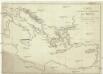
Carte des états de la république de Venise
Benátky (Itálie)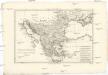
Turquie d'Europe
1 : 6960000 Balkánský poloostrov Bonne, Rigobert André
Carte de la Mer Méditerranée, 2
1 Blatt : 50 x 51 cm Froullé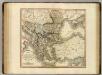
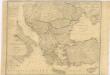
Turkey in Europe.
1 : 3450000 Cary, John, ca. 1754-1835
Bez titulu: soubor map pag. 265
Karte von dem Osmanischen Reiche in Europa

La Turchia d'Europa
1 : 10000000 Evropa jihovýchodní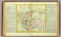
Turquie d'Europe.
1 : 6000000 Clouet, J. B. L. (Jean-Baptiste Louis), b. 1730
Orbis Romani descriptio, seu divisio per themata sub Imperatoribus Constantinopolitanis post Heraclii tempora facta
1 : 3800000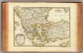
Turquie.
1 : 3900000 Janvier, Jean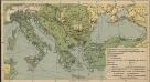
Italien und Balkanhalbinsel. Nebenkarten II. 5. Wirtschaftskarte
Südeuropa Wirtschaft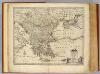
Turky in Europe.
1 : 3900000 Bowen, Emanuel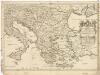
Estats de l'empire des Turqs en Europe
1 : 4270000 Evropa jihovýchodní Sanson, Guillaume Cordier, Louis chez H. Iaillot
Turquie d'Europe
1 : 2650000 par le Sr. Janvier, géographe A Vénice : par François Santini [...] chez M. Redini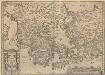
Graecia, Sophiani.[Karte], in: Theatrum orbis terrarum, S. 514.
1 Karte aus Atlas Ortelius, Abraham Vrients, Jan Baptista
Griechenland und die Länder der Balkan-Halbinsel
Plastischer Schul-Atlas über alle Theile der Erde : in 24 Karten Woldermann, G Verlag von P. Eckerlein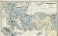
Osmânisches Reich und Nachbarländer 1391 bis 1452
1 : 5000000 Osmanisches Reich, Balkanhalbinsel Menke, Theodor
![Nova Graecia XXII. Nova Tabula. [Karte], in: Claud. Ptolemaeus. Geographia lat. cum mappis [...], S. 428.](https://images-2.georeferencer.com/images/iiif/340566059920/full/,300/0/native.jpg)

