Maps of Centru
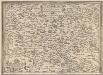
Transilvania [Karte], in: Theatrum orbis terrarum, S. 366.
1 Karte aus Atlas Ortelius, Abraham Vrients, Jan Baptista
Blatt VIII, uit: Geologische Übersichts-Karte der Österreichisch-Ungarischen Monarchie / nach den Aufnahmen der K.K. Geologischen Reichsanstalt bearb. von Franz Ritter von Hauer ; gezeichn. von Eduard Jahn
1 : 576000 Annotatie geografische gegevens: Gebaseerd op veldwerk in de jaren 1850 tot 1865 Hauer, Franz Ritter von; Jahn, Eduard; Kaiserlich-Königliche Geologische Reichsanstalt, Wenen Wien : Beck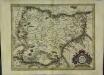
Transylvania
1 Karte : Kupferdruck ; 32 x 41 cm Mercator; Hondius excusum apud Henricum Hondium sub insigno atlantis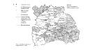
Verwaltungskarte Siebenbürgens 1847
Siebenbürgen Verwaltungsgliederung
Neueste Karte von Siebenbürgen
Grosser Hand-Atlas über alle Theile der Erde in 170 Karten Meyer, J. Verlag des Bibliographischen Instituts
Siebenburgen.
1 : 2800000 Meyer, Joseph, 1796-1856
XV, uit: General-Karte des oesterreichischen Kaiserstaates mit einem grossen Theile der angrenzenden Länder / durch Josef Scheda ... bearb. und hrsg
1 : 576000 Annotatie geografische gegevens: Maatstokken: oesterreichische Meilen, geografische oder deutsche Meilen, preussische Meilen, türkische Berri, französische Lieues, russische Werste; Maatstok per blad: wiener Klafter, öster. Meilen; Blad XIX: statistische en taalkundige informatie; Blad XIX: legenda [Wien : K.K. Militärisch-Geografisches Institut]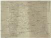
Karte von Siebenbürgen
1 : 980000 Rumunsko Mollo, Tranquillo Tranquillo Mollo
Übersichtskarte von Mittel - Europa

Bez titulu: Přehledná mapa střední Evropy

Nova et Accurata Transylvaniae
1 : 690000 Mollova mapová sbírka Valk, Gerhard Schenk, Peter I
Ungarn. Comit. Krassó, Zaránd. Walachei. Illyrien. Siebenbürgen. Comit: Hunyad, Kükülö, Unter- und Ober Weißenburger. Stühle: Dreystuhler, Repser, Schäßburg, Groß Schenker, Medjascher, Leschkirchner, Hermannstädter, Reißmärker, Mühlenbacher & Brooder Stuhl. Districte: Fogaras & Kronstadt
Ungarn Verkehrsweg
Carte de la Roumanie et pays limitrophes. Klausenbourg
1 : 500000 France. Service géographique de l'armée [Paris] : Service géographique de l'armée
Sheet XV: Karte Des Oesterreichischen Kaiserstaates.
1 : 576000 Scheda, Josef
Wurzland
Mollova mapová sbírka Hoffmann, Johannes Hoffmann, Johann
Siebenbürgen
Sedmihradsko (Rumunsko) Kipferling, Karl Joseph im Verlage des Kunst und Industrie Comptoir's
Transilvania
Mollova mapová sbírka Hoffmann, Johannes Hoffmann, Johann
Carte de la Roumanie et pays limitrophes. Bukarest
1 : 500000 France. Service géographique de l'armée [Paris] : Service géographique de l'armée
Siebenbürgen
Sedmihradsko (Rumunsko) Kunst- und Industrie Comptoir
Kolozsvár (Klausenburg), Máramaros-Sziget, Tölgyes
1 : 750000 Cluj-Napoca (Rumunsko) Erben, F. K. u. k. Militärgeographisches Institut
Kolozsvár (Klausenburg), Máramaros-Sziget, Tölgyes
1 : 750000 Cluj-Napoca (Rumunsko) Erben, F. K. u. k. Militärgeographisches Institut
Klausenburg, Máramaros-Sziget, Tölgyes
1 : 750000 K. u. k. militär-geographisches Institut
Klausenburg, Máramaros-Sziget, Tölgyes
1 : 750000 Cluj-Napoca (Rumunsko) K. k. militär-geographisches Institut
Siebenbürgen
1 : 600000 Siebenbürgen
Kleine Walachei
1 : 600000 Kleine Walachei
Gebiet um Hermannstadt
1 : 600000 Hermannstadt, Hermannstadt (Region)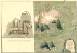
Plan des Bergwergs Weres Patack
Mollova mapová sbírka Geyer
Plan der Batalie bei Beroschan in der Walachai samt den Drei Mahlichen Stvrm den 26. Jvli 1739
Mollova mapová sbírka Geyer
Harta Cailor de Comunicatie din Judetul Argesu
Rumänien Judeţ Argeş Verkehrsweg
![Transilvania [Karte], in: Theatrum orbis terrarum, S. 366.](https://images-2.georeferencer.com/images/iiif/812561726122/full/,300/0/native.jpg)

