Maps of North West

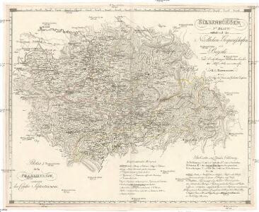
Siebenbürgen
Sedmihradsko (Rumunsko) Kipferling, Karl Joseph im Verlage des Kunst und Industrie Comptoir's
Strassen- und Eisenbahnkarte des oesterreichischen Kaiserthumes
1 : 864000 Blatt 8 Schaller, G. K.K. Militärisch-Geografisches Institut, Karten-Evidenthaltungs-Abteilung
Letecká mapa Evropy
Ungarn: Comitate: Beregh, Marmarozs, Ugocsa, Közep Szolnok, Kraszna, District Kövár. Siebenbürgen: Innerer Szolnok, Doboka, Clausenburg, Torda, Aranyoser Stuhl, Marozser Stuhl, Udvarhlyer Stuhl, Csiker Stuhl, und Bistriczer District
Ungarn Verkehrsweg
Bez titulu: Šest listů speciálních map Ukrajiny

Sheet X: Karte Des Oesterreichischen Kaiserstaates.
1 : 576000 Scheda, Josef
Bez titulu: Přehledná mapa střední Evropy

Übersichtskarte von Mittel - Europa

Kolozsvár (Klausenburg), Máramaros-Sziget, Tölgyes
1 : 750000 Cluj-Napoca (Rumunsko) Erben, F. K. u. k. Militärgeographisches Institut
Kolozsvár (Klausenburg), Máramaros-Sziget, Tölgyes
1 : 750000 Cluj-Napoca (Rumunsko) Erben, F. K. u. k. Militärgeographisches Institut
Klausenburg, Máramaros-Sziget, Tölgyes
1 : 750000 K. u. k. militär-geographisches Institut
Klausenburg, Máramaros-Sziget, Tölgyes
1 : 750000 Cluj-Napoca (Rumunsko) K. k. militär-geographisches Institut
Carte de la Roumanie et pays limitrophes. Klausenbourg
1 : 500000 France. Service géographique de l'armée [Paris] : Service géographique de l'armée
Siebenbürgen
1 : 600000 Siebenbürgen
Transilvania
Mollova mapová sbírka Hoffmann, Johannes Hoffmann, Johann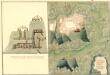
Plan des Bergwergs Weres Patack
Mollova mapová sbírka Geyer


Szilágy vármegye térképe
1 : 360000 Kogutowicz, Manó Magyar Földrajzi Intézet
C. Szathmariensis
Rumänien Komitat Sathmar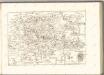
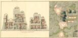
Plan deren Bergwerg Nagiay: i Offi und Bedas
Mollova mapová sbírka Geyer
Szatmár vármegye térképe
1 : 425000 Maďarsko Kogutowicz, Manó Magyar Földrajzi Intézet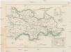
Szathmárer Comitat
1 : 280000 Satu-Mare-oblast (Rumunsko)
Szathmárer Comitat
1 : 300000 Satu-Mare (Rumunsko : oblast)
Magyar-Lapos und Makod.
from Spezialkarte der osterreichisch-ungarischen Monarchie.
Kanyahaza und Szatmar-Nemeti.
from Spezialkarte der osterreichisch-ungarischen Monarchie.
Magura.
from Spezialkarte der osterreichisch-ungarischen Monarchie.