Maps of Satu Mare
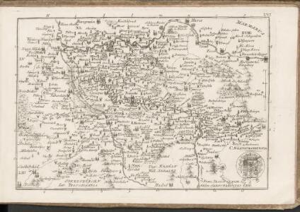
C. Szathmariensis
Rumänien Komitat Sathmar
Szathmárer Comitat
1 : 280000 Satu-Mare-oblast (Rumunsko)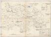
Szathmárer Comitat
1 : 300000 Satu-Mare (Rumunsko : oblast)
Szatmár vármegye térképe
1 : 425000 Maďarsko Kogutowicz, Manó Magyar Földrajzi Intézet
Generální mapa ČSR

Kanyahaza und Szatmar-Nemeti.
from Spezialkarte der osterreichisch-ungarischen Monarchie.
Jank.
from Spezialkarte der osterreichisch-ungarischen Monarchie.
Szinyer-Varalja und Kraszna-Beltek.
from Spezialkarte der osterreichisch-ungarischen Monarchie.
15 Zóna, XXVII Rovat, Nagy-Károly és Ákos Vidéke (Umgebungen von Nagy-Károly und Ákos), uit: [Geologische Specialkarte der im Reichsrathe vertretenen Königreiche und Länder der österreichisch-ungarischen Monarchie] / geologische Aufnahmen der königl. ung. Geologischen Anstalt
1 : 75000 Annotatie: Verantwoordelijkheidsvermelding in 1909 veranderd in: Königliche Ungarische Geologische Reichsanstalt; Sommige bladen in het Frans; Annotatie geografische gegevens: Coördinaten gebaseerd op nulmeridiaan van Ferro (Hierro) Königliche Ungarische Geologische Reichsanstalt; Königliche Ungarische Geologische Anstalt Budapest : [Königliche Ungarische Geologische Anstalt]
Satmar
1 : 75000 Rumunsko Vojenský zeměpisný ústav
III. vojenské mapování 4870
1 : 75000
III. vojenské mapování 4871
1 : 75000
Kanyaháza und Szatmar-Némti
1 : 75000 Sathmar, Umland Geripp: Fldw. Lendl Ritter v. Murgthal. Terrain: Oberlt. A. Vogel
Jánk
1 : 75000 Szabolcs-Szatmár-Bereg Schrift und Gerippe v. R. Dokaupil. Terrainschraffirung v. Lieut. Udalrik
Nagy-Karoly und Akos.; Spezialkarte der osterreichisch-ungarischen Monarchie.
from Spezialkarte der osterreichisch-ungarischen Monarchie. Austro-Hungarian Monarchy. Militärgeographisches Institut.,
Nagy Banya.; Spezialkarte der osterreichisch-ungarischen Monarchie.
from Spezialkarte der osterreichisch-ungarischen Monarchie. Austro-Hungarian Monarchy. Militärgeographisches Institut.,
Hosszumezo und Avas-Felsofalu.; Spezialkarte der osterreichisch-ungarischen Monarchie.
from Spezialkarte der osterreichisch-ungarischen Monarchie. Austro-Hungarian Monarchy. Militärgeographisches Institut.,
Hosszúmező und Avas-Felsőfalu
1 : 75000 Satu-Mare (Judeţ), Maramureş (Judeţ) Geripp Offiz. K. Höller. Terrain: Palitschek v. Palmforst

C. Ugocsiensis
Rumänien Ukraine Komitat Ugocsa
Berehovo a Mezötarpa
1 : 75000 Maďarsko Vojenský zeměpisný ústav
Nacy-Szollos und Huszt.
from Spezialkarte der osterreichisch-ungarischen Monarchie.
Chust
1 : 75000 Ukrajina Vojenský zeměpisný ústav
Beregszász und Mező-Tarpa
1 : 75000 Transkarpatien, Berehove Geripp: Feldw. König. Terrain: Hauptm. v. Jonak u. Hauptm. Trica
III. vojenské mapování 4769
1 : 75000
Nacy-Szőllős und Huszt
1 : 75000 Transkarpatien, Khust Geripp: Feldw. Watterich. Terrain: J. Fitz
III. vojenské mapování 4770
1 : 75000
Beregszasz und Mezo-Tarpa.
from Spezialkarte der osterreichisch-ungarischen Monarchie.