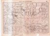
Maps of Alba

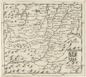
Transilvania
Mollova mapová sbírka Hoffmann, Johannes Hoffmann, Johann
Gyulafeherva [Karlsburg].
from Spezialkarte der osterreichisch-ungarischen Monarchie.
Szasz-Sebes [Muhlbach].
from Spezialkarte der osterreichisch-ungarischen Monarchie.
Riul Sebes.
from Spezialkarte der osterreichisch-ungarischen Monarchie.
Alparet [Olpret].
from Spezialkarte der osterreichisch-ungarischen Monarchie.
Nagy-Enyed.
from Spezialkarte der osterreichisch-ungarischen Monarchie.
Kolozsvar [Klausenburg].
from Spezialkarte der osterreichisch-ungarischen Monarchie.
Torda.
from Spezialkarte der osterreichisch-ungarischen Monarchie.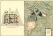
Plan des Bergwergs Rapold
Mollova mapová sbírka Geyer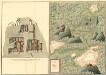
Plan des Bergwergs Szirbund
Mollova mapová sbírka Geyer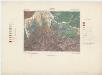
Zone 22, Kol. XXIX, Szászsebes, uit: [Geologische Specialkarte der im Reichsrathe vertretenen Königreiche und Länder der österreichisch-ungarischen Monarchie] / geologische Aufnahmen der königl. ung. Geologischen Anstalt
1 : 75000 Annotatie: Verantwoordelijkheidsvermelding in 1909 veranderd in: Königliche Ungarische Geologische Reichsanstalt; Sommige bladen in het Frans; Annotatie geografische gegevens: Coördinaten gebaseerd op nulmeridiaan van Ferro (Hierro) Königliche Ungarische Geologische Reichsanstalt; Königliche Ungarische Geologische Anstalt Budapest : [Königliche Ungarische Geologische Anstalt]
Gyulafehérvár
1 : 75000 Karlsburg
Torda
1 : 75000 Turda, Turda (Region)
III. vojenské mapování 4871
1 : 75000
Nagy-Enyed
1 : 75000 Aiud, Judeţ Klausenburg
Klausenburg
1 : 75000 Cluj-Napoca
17 Zóna, XXIX Rovat, Alparét Vidéke (Umgebungen von Olpretu), uit: [Geologische Specialkarte der im Reichsrathe vertretenen Königreiche und Länder der österreichisch-ungarischen Monarchie] / geologische Aufnahmen der königl. ung. Geologischen Anstalt
1 : 75000 Annotatie: Verantwoordelijkheidsvermelding in 1909 veranderd in: Königliche Ungarische Geologische Reichsanstalt; Sommige bladen in het Frans; Annotatie geografische gegevens: Coördinaten gebaseerd op nulmeridiaan van Ferro (Hierro) Königliche Ungarische Geologische Reichsanstalt; Königliche Ungarische Geologische Anstalt Budapest : [Königliche Ungarische Geologische Anstalt]
Alparét
1 : 75000 Bobâlna, Judeţ Klausenburg
Rîul Sebeş
1 : 75000 Sebeş (Region) Geripp: Feldw. R. Zellhofer. Terrain: Offiz. G. Leitner
Gaura
1 : 75000 Marmarosch
Gaura und Galgo.; Spezialkarte der osterreichisch-ungarischen Monarchie.
from Spezialkarte der osterreichisch-ungarischen Monarchie. Austro-Hungarian Monarchy. Militärgeographisches Institut.,
Nagy Banya.; Spezialkarte der osterreichisch-ungarischen Monarchie.
from Spezialkarte der osterreichisch-ungarischen Monarchie. Austro-Hungarian Monarchy. Militärgeographisches Institut.,
Hosszumezo und Avas-Felsofalu.; Spezialkarte der osterreichisch-ungarischen Monarchie.
from Spezialkarte der osterreichisch-ungarischen Monarchie. Austro-Hungarian Monarchy. Militärgeographisches Institut.,
Hosszúmező und Avas-Felsőfalu
1 : 75000 Satu-Mare (Judeţ), Maramureş (Judeţ) Geripp Offiz. K. Höller. Terrain: Palitschek v. Palmforst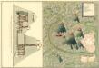
Plan von Bergwerg Szromova
Mollova mapová sbírka Geyer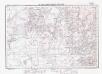
Lambert-Cholesky sheet 2783 (Tămășeni)
1 : 20000 Romanian military topographic map sheet under Lambert-Cholensky projection Institutul Geografic Militar geo-spatial.org Institutul Geografic Militar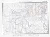
Lambert-Cholesky sheet 2782 (Gherța Mică)
1 : 20000 Romanian military topographic map sheet under Lambert-Cholensky projection Institutul Geografic Militar geo-spatial.org Institutul Geografic Militar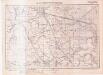
Lambert-Cholesky sheet 2781 (Livada și Medișa)
1 : 20000 Romanian military topographic map sheet under Lambert-Cholensky projection Serviciul Geografic al Armatei geo-spatial.org Serviciul Geografic al Armatei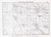
Lambert-Cholesky sheet 2780 (Apa)
1 : 20000 Romanian military topographic map sheet under Lambert-Cholensky projection Institutul Geografic Militar geo-spatial.org Institutul Geografic Militar