Maps of Grampian Mountains

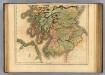
Scotiae Provintiae; Inter Taum Fluvium et Septentrionales oras Angliae. [Karte], in: Novus atlas absolutissimus, Bd. 8, S. 160.
1 Karte aus Atlas Janssonius Offizin
Composite: Lanarkshire.
1 : 82000 Thomson, John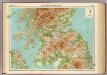
Scotland - southern section.
1 : 633600 John Bartholomew & Co.
Scotland southern.
1 : 700000 Lizars, Daniel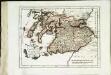
Des Königreichs Scotland südlicher Theil
1 Karte : Kupferdruck ; 19 x 25 cm Reilly F. J. J. von Reilly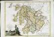
La Scozia meridionale
1 Karte : Kupferdruck ; 30 x 39 cm Zatta; Zuliani; Pitteri presso Antonio Zatta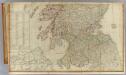
Scotland (south)
1 : 450000 Campbell, Robert, Lieutenant; Kitchin, Thomas; Robert Laurie & James Whittle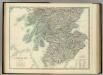
Scotland (southern sheet).
1 : 633600 Johnston, Alexander Keith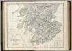
Scotland S.
1 : 633600 Johnston, Alexander Keith, 1804-1871
A general map of Scotland and islands thereto belonging, 4
1 Blatt : 92 x 62 cm s.n.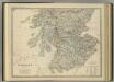
Scotland (southern sheet).
1 : 633600 Johnston, Alexander Keith
Scotland SE.
1 : 486830 Stanford, Edward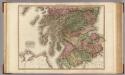
Scotland, southern part.
1 : 518000 Pinkerton, John, 1758-1826
Scotland I.
1 : 765000 Society for the Diffusion of Useful Knowledge (Great Britain)
Scotland 1.
1 : 760320 Letts, Son & Co.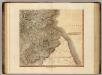
Scotland SE.
1 : 500000 Cary, John, ca. 1754-1835
Scotland[Motoring Map of]
London : "Geographia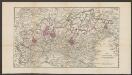
Northumbria, Cumberlandia, Et Dunelmensis Episcopatus. [Karte], in: Atlas, sive, Cosmographicae meditationes de fabrica mundi et fabricati figura, S. 110.
1 Karte aus Atlas Mercator, Gerhard
Northumbria, Cumberlandia, Et Dunelmensis Episcopatus. [Karte], in: Gerardi Mercatoris Atlas, sive, Cosmographicae meditationes de fabrica mundi et fabricati figura, S. 112.
1 Karte aus Atlas Mercator, Gerhard Montanus, Petrus

Economic Map of Central Scotland - Bartholomew's 'Survey Atlas of Scotland'
1 : 316800 Topographic maps John Bartholomew & Son, Ltd John Bartholomew & Son, Ltd
Watershed map England, Wales 1.
1 : 760320 Letts, Son & Co.
England and Wales. England No. 2.
1 : 700000 Society for the Diffusion of Useful Knowledge (Great Britain)
Scotland / J. Ainslie, 8
1 Blatt : 68 x 57 cm Ainslie, Faden
Carte des environs d'Edenburg
1 Karte : Kupferdruck ; 45 x 57 cm Robert de Vaugondy; Arrivet; Fortin; Dussy; Dorret chez le Sr. Fortin ing.r mécanicien du roy rue de la harpe près la rue du Foin
Northumbria, Cumberlandia, et Dunelmensis Episcopatus
1 : 396000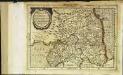
Northvmbria, Cvmberlandia, et Dvnelmensis episcopatus
1 Karte : Kupferdruck ; 17 x 24 cm Mercator; Keere Cloppenburgh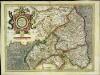
Northvmbria, Cvmberlandia, et Dvnelmensis episcopatus
1 Karte : Kupferdruck ; 33 x 45 cm Mercator; Hondius Henricus Hondius
![Scotiae Provintiae; Inter Taum Fluvium et Septentrionales oras Angliae. [Karte], in: Novus atlas absolutissimus, Bd. 8, S. 160.](https://images-2.georeferencer.com/images/iiif/324835281521/full/,300/0/native.jpg)

