Maps of Turkey

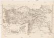
Asia Minor [Karte], in: Atlas nouveau, contenant toutes les parties du monde [...], Bd. 2, S. 222.
1 Karte aus Atlas Sanson, Nicolas Jaillot, Alexis Hubert und Mortier, Pieter
Tabula Asiae I. [Karte], in: Geographia universalis vetus et nova complectens Claudii Ptolemaei Alexandrini enarrationis libros VIII, S. 266.
1 Karte aus Atlas Münster, Sebastian [und Ptolemaeus, Claudius]
Tabula Prima Asie [Karte], in: Claudii Ptolemei viri Alexandrini mathematice discipline philosophi doctissimi geographie opus [...], S. 193.
1 Karte aus Atlas Waldseemüller, Martin [und Ptolemaeus, Claudius] Übelin, Georg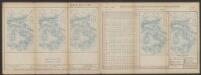
Tabula Asiae I. [Karte], in: Claud. Ptolemaeus. Geographia lat. cum mappis [...], S. 296.
1 Karte aus Atlas Münster, Sebastian [und Ptolemaeus, Claudius]
Ansiedelungsschwerpunkte von Bulgarien-Türken 1950/51
Türkei Türken, Siedlung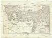
[Balkán a Malá Asie]
1 : 2850000 Balkánský poloostrov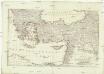
[Balkán a Malá Asie]
1 : 2850000 Balkánský poloostrov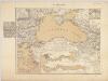
Das Schwarze Meer nebst Kriegsschauplatz in der europäisch. u. asiatisch. Türkei / von F. Handtke
1 : 2900000 titelvariant: Das Schwarze Meer; Annotatie geografische gegevens: Met schaalstokken Friedrich H. Handtke 1815-1879 Glogau : C. Flemming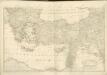
Schul-Atlas für die alte Erdbeschreibung : zur allgemeinen Schul-encyclopädie gehörig
J. H. Campe Zusammensetzung und Zeichnung von [...] Dufour, unter Leitung von Heusinger ; gestochen von Frentzel. Braunschweig : Schulbuchhandlung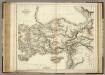
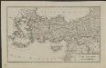
Modern Asia Minor.
1 : 2850000 Playfair, Principal
Asiae Minoris Mappa Generalis ad Caesarum Tempus.
1 : 4000000 Vivien de St Martin, L.

General Karte des Schwarzen Meeres mit den Karten des Bosporus und der Dardanellenstrasse

Prima Asie Tabula [Karte], in: [Clavdii Ptholomei Cosmographi ...], S. 299.
1 Karte aus Atlas Nicolaus Germanus [und Ptolemaeus, Claudius]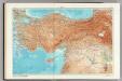
146-147. Turkey. Ankara. The World Atlas.
1 : 2500000 USSR (Union of Soviet Socialist Republics).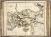
Asia Minor.
1 : 2800000 Playfair, Principal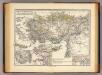
Pontus et Bithynia, Asia, Lycia et Pamphylia, Galatia, Cappadocia, Syria, Creta, Cyprus.
1 : 3900000 Menke, Th.
Natoliae Sive Asia Minor [Karte], in: Gerardi Mercatoris Atlas, sive, Cosmographicae meditationes de fabrica mundi et fabricati figura, S. 520.
1 Karte aus Atlas Mercator, Gerhard Montanus, Petrus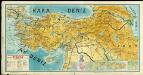
Fiziki Türkiye No18

[Klein-Asien & Syrien, Nebst den Westlichen Theilen von Armenien, Kurdistan & Mesopotamien]
Handatlas über alle Theile der Erde und über das Weltgebäude Stieler, Adolf Justus Perthes
Asiæ quæ vulgo minor dicitur et Syriæ tabula geographica, quantum per subsidia licuit elaborata, opere, si quod aliud in antiquâ geographiâ, arduo. quam tabulam clariss. Dom. Comes de Caylus in ære incidi curavit
1 : 2500000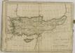
Asia Minor, Syria, Mesopotamia, Armenia, Assyria
1 : 1900000 Arménie Reichard, Christian Gottlieb Campius, D. a D. Campio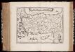
Natolia, quæ olim Asia Minor
1 : 3500000 Annotatie: Kaart vervaardigd ca. 1635; Kaart uitg. tussen ca. 1635-ca. 1670; Origineel is Blad 181 in atlas factice; Annotatie geografische gegevens: Schaalstok op kaart: 20 Milliaria Germanica (=4,3 cm) Willem Jansz Blaeu 1571-1638; Joan Blaeu 1597/98-1673 [Amsterdam] : [Willem Jansz. en Joan Blaeu]
Klein-Asien & Syrien nebst den westlichen Theilen von Armenien, Kurdistan & Mesopotamien
Hand-Atlas über alle Theile der Erde und über das Weltgebäude Stieler, Adolf Justus Perthes
Natolia, quae olim Asia Minor. [Karte], in: Le théâtre du monde, ou, Nouvel atlas contenant les chartes et descriptions de tous les païs de la terre, Bd. 2, S. 273.
1 Karte aus Atlas Blaeu, Willem Janszoon und Blaeu, Joan Blaeu, Willem Janszoon
Carte de l'Asie Minevre ou de la Natolie et du Pont Evxin
1 : 3300000 Anatolie (Turecko) Hase, Johann Matthias aux depens des Heritiers de Homann
CARTE DE L'ASIE MINEVRE ou de la NATOLIE et du PONT EVXIN
1 : 3300000 Anatolie (Turecko) Hase, Johann Matthias aux depens des Heritiers de Homann
Carte de l'Asie Minevre ou de la Natolie et du Pont Evxin, tirée des voyages et des observations des anciens et modernes, et dresée suivant les principes d'une nouvelle projection
1 : 3300000 Malá Asie Hase, Johann Matthias Heritiers de Homann
![Asia Minor [Karte], in: Atlas nouveau, contenant toutes les parties du monde [...], Bd. 2, S. 222.](https://images-2.georeferencer.com/images/iiif/939899250663/full/,300/0/native.jpg)

