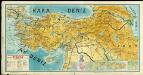
Maps of Turkey
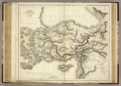
Modern Asia Minor.
1 : 2850000 Playfair, Principal
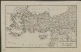
Asia Minor.
1 : 2800000 Playfair, Principal
Natoliae Sive Asia Minor [Karte], in: Gerardi Mercatoris Atlas, sive, Cosmographicae meditationes de fabrica mundi et fabricati figura, S. 520.
1 Karte aus Atlas Mercator, Gerhard Montanus, Petrus
Asiæ quæ vulgo minor dicitur et Syriæ tabula geographica, quantum per subsidia licuit elaborata, opere, si quod aliud in antiquâ geographiâ, arduo. quam tabulam clariss. Dom. Comes de Caylus in ære incidi curavit
1 : 2500000
Asia Minor, Syria.
1 : 6000000 Anville, Jean Baptiste Bourguignon d, 1697-1782
Tabula Prima Asie [Karte], in: Claudii Ptolemei viri Alexandrini mathematice discipline philosophi doctissimi geographie opus [...], S. 193.
1 Karte aus Atlas Waldseemüller, Martin [und Ptolemaeus, Claudius] Übelin, Georg
Asia Minor.
1 : 5800000 Arrowsmith, Aaron; Lewis, Samuel
Asia Minor.
1 : 6000000 Arrowsmith, Aaron; Lewis, Samuel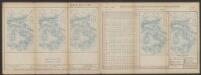
Tabula Asiae I. [Karte], in: Claud. Ptolemaeus. Geographia lat. cum mappis [...], S. 296.
1 Karte aus Atlas Münster, Sebastian [und Ptolemaeus, Claudius]
Asiae, quae vulgo Minor dicitur, et Syriae tabula geographica.
1 : 2550000 Anville, Jean Baptiste Bourguignon d, 1697-1782
Asiæ quæ vulgo minor dicitur et Syriæ tabula geographica
1 Karte : Kupferdruck ; 48 x 59 cm Anville; Caylus; Berndt in officina Weigelio-Schneideriana
Asiæ quæ vulgo minor dicitur et Syriæ tabula geographica
1 Karte : Kupferdruck ; 48 x 59 cm Anville; Caylus; Berndt in officina Weigelio-Schneideriana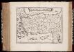
Natolia, quæ olim Asia Minor
1 : 3500000 Annotatie: Kaart vervaardigd ca. 1635; Kaart uitg. tussen ca. 1635-ca. 1670; Origineel is Blad 181 in atlas factice; Annotatie geografische gegevens: Schaalstok op kaart: 20 Milliaria Germanica (=4,3 cm) Willem Jansz Blaeu 1571-1638; Joan Blaeu 1597/98-1673 [Amsterdam] : [Willem Jansz. en Joan Blaeu]
Asia Minor.
1 : 12000000 Fenner, Rest.
Tabula Asiae I. [Karte], in: Geographia universalis vetus et nova complectens Claudii Ptolemaei Alexandrini enarrationis libros VIII, S. 266.
1 Karte aus Atlas Münster, Sebastian [und Ptolemaeus, Claudius]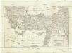
[Balkán a Malá Asie]
1 : 2850000 Balkánský poloostrov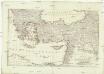
[Balkán a Malá Asie]
1 : 2850000 Balkánský poloostrov
Asia minor in usum scholarum descripta
1 : 5850000 Malá Asie Mollo, Tranquillo T. Mollo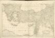
Schul-Atlas für die alte Erdbeschreibung : zur allgemeinen Schul-encyclopädie gehörig
J. H. Campe Zusammensetzung und Zeichnung von [...] Dufour, unter Leitung von Heusinger ; gestochen von Frentzel. Braunschweig : Schulbuchhandlung
Natoliae, Quae Olim Asia Minor, Nova Descriptio. [Karte], in: Theatrum orbis terrarum, S. 411.
1 Karte aus Atlas Ortelius, Abraham Vrients, Jan Baptista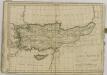
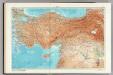
146-147. Turkey. Ankara. The World Atlas.
1 : 2500000 USSR (Union of Soviet Socialist Republics).
Colonia romana, Tabula geographica provinciarum et urbium.
1 : 5000000 L'Isle, Guillaume de, 1675-1726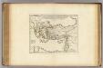
Colonia Romana, Tabula Geographica Provinciarum et Urbium.
1 : 5000000 L'Isle, Guillaume de, 1675-1726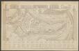
Natolia, quae olim Asia Minor. [Karte], in: Le théâtre du monde, ou, Nouvel atlas contenant les chartes et descriptions de tous les païs de la terre, Bd. 2, S. 273.
1 Karte aus Atlas Blaeu, Willem Janszoon und Blaeu, Joan Blaeu, Willem Janszoon
Natoliae, Quae Olim Asia Minor, Nova Descriptio. [Karte], in: Theatrum orbis terrarum, S. 310.
1 Karte aus Atlas Ortelius, Abraham
Natolia, quae olim Asia Minor. [Karte], in: Gerardi Mercatoris et I. Hondii Newer Atlas, oder, Grosses Weltbuch, Bd. 2, S. 344.
1 Karte aus Atlas Mercator, Gerhard und Hondius, Jodocus Jansson, Jan