Maps of Turkey
Schul-Atlas für die alte Erdbeschreibung : zur allgemeinen Schul-encyclopädie gehörig
J. H. Campe Zusammensetzung und Zeichnung von [...] Dufour, unter Leitung von Heusinger ; gestochen von Frentzel. Braunschweig : Schulbuchhandlung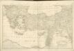
[Balkán a Malá Asie]
1 : 2850000 Balkánský poloostrov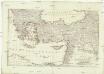
[Balkán a Malá Asie]
1 : 2850000 Balkánský poloostrov
Natoliae Sive Asia Minor [Karte], in: Gerardi Mercatoris Atlas, sive, Cosmographicae meditationes de fabrica mundi et fabricati figura, S. 520.
1 Karte aus Atlas Mercator, Gerhard Montanus, Petrus
Colonia romana, Tabula geographica provinciarum et urbium.
1 : 5000000 L'Isle, Guillaume de, 1675-1726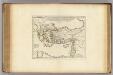
Colonia Romana, Tabula Geographica Provinciarum et Urbium.
1 : 5000000 L'Isle, Guillaume de, 1675-1726
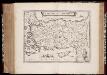
Natoliae, Quae Olim Asia Minor, Nova Descriptio. [Karte], in: Theatrum orbis terrarum, S. 411.
1 Karte aus Atlas Ortelius, Abraham Vrients, Jan Baptista

Natoliae, Quae Olim Asia Minor, Nova Descriptio. [Karte], in: Theatrum orbis terrarum, S. 310.
1 Karte aus Atlas Ortelius, Abraham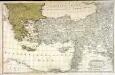
Dritter Theil der Karte von Europa welcher das südliche Russland Polen und Ungarn die europæische, und beinahe die ganze asiatische Türkei enthælt, 2
1 Blatt : 54 x 84 cm F.A. Schrämbl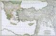
Troisième partie de la carte d'Europe contenant le midi de la Russie, la Pologne et la Hongrie, la Turquie y compris celle d'Asie presqu'entière, 2
1 Blatt : 53 x 84 cm chez l'auteur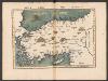
Tabula Nova Asie Minoris [Karte], in: Claudii Ptolemei viri Alexandrini mathematice discipline philosophi doctissimi geographie opus [...], S. 269.
1 Karte aus Atlas Waldseemüller, Martin [und Ptolemaeus, Claudius] Übelin, Georg
[Klein-Asien & Syrien, Nebst den Westlichen Theilen von Armenien, Kurdistan & Mesopotamien]
Handatlas über alle Theile der Erde und über das Weltgebäude Stieler, Adolf Justus Perthes
Tabula geographica ad acta aposto
Středozemní moře-oblast východní Berka, Jan
Natoliae, Quae Olim Asia Minor, Nova Descriptio. [Karte], in: Theatrum orbis terrarum, S. 119.
1 Karte aus Atlas Ortelius, Abraham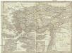
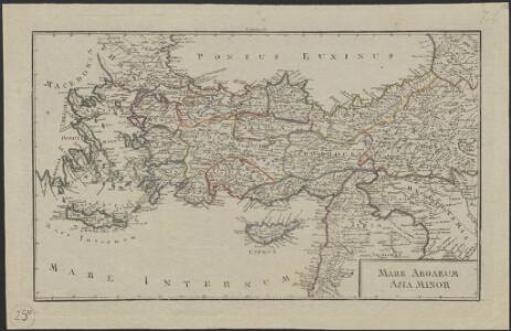
Asia minor, Syria, Cyprus, Creta & insulae maris Aegaei
1 : 3800000 Egejské moře Spruner, Karl von Poppey Justus Perthes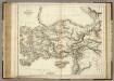
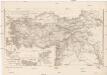
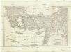
Modern Asia Minor.
1 : 2850000 Playfair, Principal
Tabula Prima Asie [Karte], in: Claudii Ptolemei viri Alexandrini mathematice discipline philosophi doctissimi geographie opus [...], S. 193.
1 Karte aus Atlas Waldseemüller, Martin [und Ptolemaeus, Claudius] Übelin, Georg
Klein-Asien & Syrien nebst den westlichen Theilen von Armenien, Kurdistan & Mesopotamien
Hand-Atlas über alle Theile der Erde und über das Weltgebäude Stieler, Adolf Justus Perthes
Asiæ quæ vulgo minor dicitur et Syriæ tabula geographica, quantum per subsidia licuit elaborata, opere, si quod aliud in antiquâ geographiâ, arduo. quam tabulam clariss. Dom. Comes de Caylus in ære incidi curavit
1 : 2500000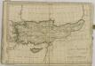
Natolia, quæ olim Asia Minor
1 : 3500000 Annotatie: Kaart vervaardigd ca. 1635; Kaart uitg. tussen ca. 1635-ca. 1670; Origineel is Blad 181 in atlas factice; Annotatie geografische gegevens: Schaalstok op kaart: 20 Milliaria Germanica (=4,3 cm) Willem Jansz Blaeu 1571-1638; Joan Blaeu 1597/98-1673 [Amsterdam] : [Willem Jansz. en Joan Blaeu]
Asia Minor, Syria.
1 : 6000000 Anville, Jean Baptiste Bourguignon d, 1697-1782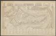
Natolia, quae olim Asia Minor. [Karte], in: Le théâtre du monde, ou, Nouvel atlas contenant les chartes et descriptions de tous les païs de la terre, Bd. 2, S. 273.
1 Karte aus Atlas Blaeu, Willem Janszoon und Blaeu, Joan Blaeu, Willem Janszoon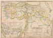
Empire Ottoman : division administrative
1 : 1500000 Huber, R F. Loeffler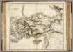
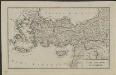
Asia Minor.
1 : 2800000 Playfair, Principal
Kleinasien
1 : 5000000 Izmir (Turecko : oblast) Meyer, Joseph Bibliographisches Institut
Klein-Asien & Syrien Nebst Den Westlichen Theilen Von Armenien, Kurdistan & Mesopotamien.
1 : 3700000 Petermann, A.