Maps of Turkey
Asia minor, Syria, Cyprus, Creta & insulae maris Aegaei
1 : 3800000 Egejské moře Spruner, Karl von Poppey Justus Perthes
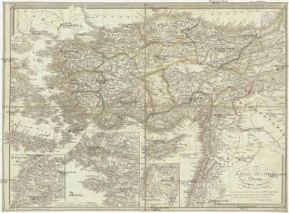
Klein-Asien & Syrien Nebst Den Westlichen Theilen Von Armenien, Kurdistan & Mesopotamien.
1 : 3700000 Petermann, A.
Schul-Atlas für die alte Erdbeschreibung : zur allgemeinen Schul-encyclopädie gehörig
J. H. Campe Zusammensetzung und Zeichnung von [...] Dufour, unter Leitung von Heusinger ; gestochen von Frentzel. Braunschweig : Schulbuchhandlung
Natoliae, Quae Olim Asia Minor, Nova Descriptio. [Karte], in: Theatrum orbis terrarum, S. 411.
1 Karte aus Atlas Ortelius, Abraham Vrients, Jan Baptista
Natoliae, Quae Olim Asia Minor, Nova Descriptio. [Karte], in: Theatrum orbis terrarum, S. 310.
1 Karte aus Atlas Ortelius, Abraham
Natoliae, Quae Olim Asia Minor, Nova Descriptio. [Karte], in: Theatrum orbis terrarum, S. 119.
1 Karte aus Atlas Ortelius, Abraham
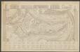
[Klein-Asien & Syrien, Nebst den Westlichen Theilen von Armenien, Kurdistan & Mesopotamien]
Handatlas über alle Theile der Erde und über das Weltgebäude Stieler, Adolf Justus Perthes
Klein-Asien & Syrien nebst den westlichen Theilen von Armenien, Kurdistan & Mesopotamien
Hand-Atlas über alle Theile der Erde und über das Weltgebäude Stieler, Adolf Justus Perthes
Natolia, quae olim Asia Minor. [Karte], in: Le théâtre du monde, ou, Nouvel atlas contenant les chartes et descriptions de tous les païs de la terre, Bd. 2, S. 273.
1 Karte aus Atlas Blaeu, Willem Janszoon und Blaeu, Joan Blaeu, Willem Janszoon
Colonia romana, Tabula geographica provinciarum et urbium.
1 : 5000000 L'Isle, Guillaume de, 1675-1726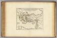
Colonia Romana, Tabula Geographica Provinciarum et Urbium.
1 : 5000000 L'Isle, Guillaume de, 1675-1726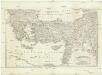
[Balkán a Malá Asie]
1 : 2850000 Balkánský poloostrov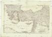
[Balkán a Malá Asie]
1 : 2850000 Balkánský poloostrov
Asia Minor, Syria.
1 : 6000000 Anville, Jean Baptiste Bourguignon d, 1697-1782
Asia Minor, Syria, Phoenice et Coelesyria
Türkei, Levante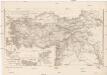
Asia Minor, Syria, Mesopotamia, Armenia, Assyria
1 : 1900000 Arménie Reichard, Christian Gottlieb Campius, D. a D. Campio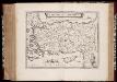
Natolia, quæ olim Asia Minor
1 : 3500000 Annotatie: Kaart vervaardigd ca. 1635; Kaart uitg. tussen ca. 1635-ca. 1670; Origineel is Blad 181 in atlas factice; Annotatie geografische gegevens: Schaalstok op kaart: 20 Milliaria Germanica (=4,3 cm) Willem Jansz Blaeu 1571-1638; Joan Blaeu 1597/98-1673 [Amsterdam] : [Willem Jansz. en Joan Blaeu]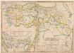
Empire Ottoman : division administrative
1 : 1500000 Huber, R F. Loeffler
Natoliae Sive Asia Minor [Karte], in: Gerardi Mercatoris Atlas, sive, Cosmographicae meditationes de fabrica mundi et fabricati figura, S. 520.
1 Karte aus Atlas Mercator, Gerhard Montanus, Petrus
Asia Minor et Syria
Schul-Atlas der alten Welt bei Justus Perthes
Natolia, quae olim Asia Minor. [Karte], in: Theatrum orbis terrarum, sive, Atlas novus, Bd. 2, S. 280.
1 Karte aus Atlas Blaeu, Joan Blaeu, Willem Janszoon
Kleinasien
1 : 5000000 Izmir (Turecko : oblast) Meyer, Joseph Bibliographisches Institut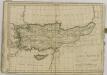

Natolia, quae olim Asia Minor. [Karte], in: Gerardi Mercatoris et I. Hondii Newer Atlas, oder, Grosses Weltbuch, Bd. 2, S. 344.
1 Karte aus Atlas Mercator, Gerhard und Hondius, Jodocus Jansson, Jan
Klein-Asien, Syrien & c.
Adolf Stieler's Handatlas über alle Theile der Erde und über das Weltgebäude Stieler, Adolf Justus Perthes
Turkey, Syria, and Lebanon. Palestine and Trans-Jordan. Arabia.
1 : 4598000 Hammond, C.S.
Asiæ quæ vulgo minor dicitur et Syriæ tabula geographica, quantum per subsidia licuit elaborata, opere, si quod aliud in antiquâ geographiâ, arduo. quam tabulam clariss. Dom. Comes de Caylus in ære incidi curavit
1 : 2500000
Atlas für Industrie- und Handelsgeographie: Für commercielle und technische Lehranstalten, für Kaufleute und Industrielle