Maps of Schwetzingen

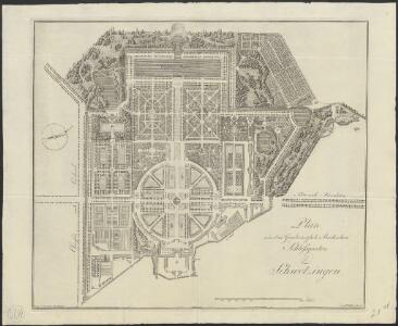
Plan von dem Grosherzoglich Badischen Schlossgarten zu Schwetzingen
1 : 2000 gez. von Garten-Director Zeyher gest. v. F. Wolff [Mannheim] : [s.n.]
Meßtischblatt 6616 : Speyer, 1924
1 : 250000 Speyer. - [Stand ca. 1924]. - 1:25000. - Wiesbaden: Hauptvermessungsabteilung XI, 1924. - 1 Kt.
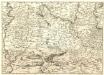
Carte über den Lauf des Rheins von Lauterburg bis unterhalb Sandhofen längs der Badisch - Bayerschen Grenze

Landkartendarstellung
Meyer, Joseph Bibliogr. Institut
Vorstellung der Linie u[nd] Inondation von Bruchsahl bis Ketsch
1 : 60000 Mollova mapová sbírka Riecke, Gustav Friedrich Homann, Johann Baptista - dědici
Le Flambeau de la Guerre Allumee au Rhin
Mollova mapová sbírka Delisle, Guillaume Schenk, Peter II
Geographica Provinciarum Sveviae Descriptio =
Mollova mapová sbírka Hurter, Johann Christoph Bodenehr, Gabriel
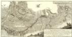
Carte von Linie und Innondation, von Bruchsal bis Kethsch, woselbst die Innondation in Rhein fließet.
1 : 65000 Mollova mapová sbírka Riecke, Gustav Friedrich Bodenehr, Gabriel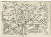
Geographica Provinciarum Sveviae Descriptio =
Mollova mapová sbírka Hurter, Johann Christoph Bodenehr, Johann Georg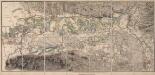
[Topographische Charte der Gegend zwischen Rhein, Neckar und Mayn]
Meister, G.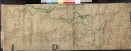
Le Cours Du Rhin Depuis Spire juisqu'à Mayence, les marches et Contremarches de l'Armée Francoise et les Camps y sont marqués Come aussi de l'Armée Alliée du coté du Main l'ann 1743 avec la Situation de l'Odewwald et du Berg Straass
Denis, Ferdinand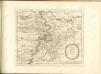
Accurate Special-Charte der Gegend des Rheins, von Ettlingen, Carls Ruhe, Philippsburg, Bruchsal, bis Mannheim, etc. Entworffen
Riecke, Gustav Friedrich; Ostertag, Heinrich Jonas; Cöntgen, Bartolomäus Anton Brönner
Section Worms, uit: Charte von dem Grossherzogtum Hessen und dem Herzogtum Nassau / trigonometrisch aufgenommen und hrsg. von C.L.P. Eckhardt
1 : 200000 titelvariant: Karte von Hessen und Nassau Eckhardt, C. L. P Darmstadt : Joh. Wilh. Heyer
Carte Particuliere de Pays qui sont situéz entre le Rhein, la Saare, la Moselle, et la Basse Alsace
1 : 150000 Mollova mapová sbírka Jaillot, Alexis-Hubert Jaillot, Alexis Hubert
Exact und Gantz accurater Plan
1 : 570000 Mollova mapová sbírka Geyer, Friedrich W. Berndt, Johann Christoph Geyer, Friedrich
Le Cours du Rhein, depuis Spire jusqu'a Mayence
1 : 180000 Mollova mapová sbírka Fer, Nicolas de Fer, Nicolas de
Special Carte des Rheinlaufes von Speier bis Bingen nebst den angraentzenden Gegenden von beiden Ufern bis an die Gebirge
1 : 250000 Bingen (Německo) Dewarat, Peter Verhelst, Aegid Schwan und Götz
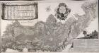
Suevia Universa
1 : 170000 Mollova mapová sbírka Michal, Jacques de Seutter, Matthäus Seutter, Matthäus
Carlsruhe - Stuttgart
1 : 200000 Herder, Benjamin
Carte Particuliere des Pays qui sont situéz entre le Rhein, la Saare, la Moselle, et la Basse Alsace
1 : 150000 Mollova mapová sbírka Mortier, Pieter Mortier, Pierre
Erpach Comitatus. [Karte], in: Novus atlas absolutissimus, Bd. 2, S. 192.
1 Karte aus Atlas Janssonius Offizin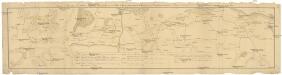
Camps et marches de l'armée imperiale com[m]andée par S.A.S. le prince de Savoye pour retourner de Wesenthal prés de Philippsbourg, et aller passer le Rhein a Mayence, l'armée de France étant campé a Oppenheim prés de céte ville
Mannheim (Německo) Müller, Johann Conrad
Territorium Seculare Episcopatvs Spirensis una cum terris adiacentibus
1 : 140000 Mollova mapová sbírka Blödtner, Cyriak Homann, Johann Baptista - dědici
Erpach Comitatus. [Karte], in: Novus Atlas, das ist, Weltbeschreibung, Bd. 1, S. 270.
1 Karte aus Atlas Blaeu, Joan Blaeu, Willem Janszoon
Erpach Comitatus. [Karte], in: Le théâtre du monde, ou, Nouvel atlas contenant les chartes et descriptions de tous les païs de la terre, Bd. 1, S. 299.
1 Karte aus Atlas Blaeu, Willem Janszoon und Blaeu, Joan Blaeu, Willem Janszoon
Erpach Comitatus. [Karte], in: Theatrum orbis terrarum, sive, Atlas novus, Bd. 1, S. 260.
1 Karte aus Atlas Blaeu, Joan Blaeu, Willem Janszoon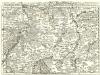
Staaten ahm Rhein, und Necker
1 : 180000 Mollova mapová sbírka Person, Nikolaus Person, Nicolas