Maps of Heidelberg

Landkartendarstellung
Meyer, Joseph Bibliogr. Institut
Meßtischblatt 32 : Neckargemünd, 1878
1 : 250000 Neckargemünd. - 1:25000. - Leipzig: Giesecke & Devrient, 1878. - 1 Kt.
Meßtischblatt 23 : Heidelberg, 1878
1 : 250000 Heidelberg. - 1:25000. - Leipzig: Giesecke & Devrient, 1878. - 1 Kt.
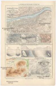
Heidelberg

Meßtischblatt 33 : Epfenbach, 1936
1 : 250000 Epfenbach. - [Hrsg.] 1880, bericht. 1936. - 1:25000. - [Karlsruhe]: Bad. Fin.- u. Wirtsch.-Min., Abtlg., 1936. - 1 Kt.
Meßtischblatt 24 : Eberbach, 1880
1 : 250000 Eberbach. - 1:25000. - Leipzig: Giesecke & Devrient, 1880. - 1 Kt.
Meßtischblatt 6616 : Speyer, 1924
1 : 250000 Speyer. - [Stand ca. 1924]. - 1:25000. - Wiesbaden: Hauptvermessungsabteilung XI, 1924. - 1 Kt.
Meßtischblatt [6517] : Ladenburg, 1910
1 : 250000 Ladenburg. - 2. Aufl., erg. 1904, einz. Nachtr. 1910. - 1:25000. - Leipzig: Giesecke & Devrient, 1910. - 1 Kt.
Meßtischblatt 22 : Ladenburg, 1881
1 : 250000 Ladenburg. - 1:25000. - Leipzig: Giesecke & Devrient, 1881. - 1 Kt.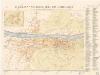
Beckmann ́s Neuester Plan von Heidelberg

Plan der Stadt Heidelberg & Umgegend
1 : 10000 Heidelberg Petters
Plan von dem Grosherzoglich Badischen Schlossgarten zu Schwetzingen
1 : 2000 gez. von Garten-Director Zeyher gest. v. F. Wolff [Mannheim] : [s.n.]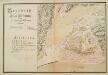
Grundriß der Stadt Hirschhorn nebst den dabeiliegenden Gebäuden
Müller, A.
Le Flambeau de la Guerre Allumee au Rhin
Mollova mapová sbírka Delisle, Guillaume Schenk, Peter II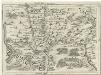
Geographica Provinciarum Sveviae Descriptio =
Mollova mapová sbírka Hurter, Johann Christoph Bodenehr, Gabriel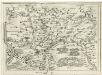
Geographica Provinciarum Sveviae Descriptio =
Mollova mapová sbírka Hurter, Johann Christoph Bodenehr, Johann Georg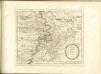
Camps et marches de l'armée imperiale com[m]andée par S.A.S. le prince de Savoye pour retourner de Wesenthal prés de Philippsbourg, et aller passer le Rhein a Mayence, l'armée de France étant campé a Oppenheim prés de céte ville
Mannheim (Německo) Müller, Johann Conrad
Territorium Seculare Episcopatvs Spirensis una cum terris adiacentibus
1 : 140000 Mollova mapová sbírka Blödtner, Cyriak Homann, Johann Baptista - dědici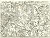
Staaten ahm Rhein, und Necker
1 : 180000 Mollova mapová sbírka Person, Nikolaus Person, Nicolas
Mannheim 113, uit: [W. Liebenow's Special-Karte von Mittel-Europa]
1 : 300000 titelvariant: W. Liebenow's Mittel-Europa; Annotatie: Titel boven de bladen: W. Liebenow's Mittel-Europa Johannes Wilhelm Liebenow 1822-1897 Hannover : Hermann Oppermann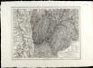
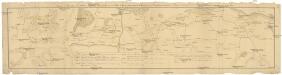
SpecialKarte von dem Odenwald, dem Bauland und einem Theil des Spessart's
1 : 216000 Haas, Johann Heinrich; Meister, G.; Felsing, Conrad

Suevia universa IX. tabulis delineata, 1
1 Blatt : s.n.
Mannheim 113, uit: Special-Karte von Mittel-Europa / nach amtlichen Quellen bearbeitet von W. Liebenow
1 : 300000 titelvariant: W. Liebenow's Mittel-Europa; Annotatie: Titel boven de bladen: W. Liebenow's Mittel-Europa Johannes Wilhelm Liebenow 1822-1897 Frankfurt a. M. : Ludwig Ravenstein
Geognostische Reise-Karte der Umgegend von Heidelberg
1 : 250000 Groos
Geognostische Karte von dem Odenwald und einigen angraenzenden Gegenden
1 : 235000 Odenwald, pohoří (Německo) Klipstein, A. MK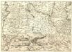
S.R.Imp. Circuli Franconici Geographica Delineatio Francken-Land mit Seinen Gräntzen
Mollova mapová sbírka Endter, Wolfgang Moritz Endter, Wolfgang Moritz
Section Erbach, uit: Charte von dem Grossherzogtum Hessen und dem Herzogtum Nassau / trigonometrisch aufgenommen und hrsg. von C.L.P. Eckhardt
1 : 200000 titelvariant: Karte von Hessen und Nassau Eckhardt, C. L. P Darmstadt : Joh. Wilh. Heyer