Maps of Landkreis Karlsruhe

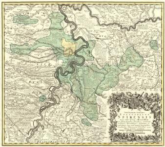
Territorium Seculare Episcopatvs Spirensis una cum terris adiacentibus
1 : 140000 Mollova mapová sbírka Blödtner, Cyriak Homann, Johann Baptista - dědici
Suevia universa IX. tabulis delineata, 1
1 Blatt : s.n.
Carte Particuliere de Pays qui sont situéz entre le Rhein, la Saare, la Moselle, et la Basse Alsace
1 : 150000 Mollova mapová sbírka Jaillot, Alexis-Hubert Jaillot, Alexis Hubert
Suevia Universa
1 : 170000 Mollova mapová sbírka Michal, Jacques de Seutter, Matthäus Seutter, Matthäus
Staaten ahm Rhein, und Necker
1 : 180000 Mollova mapová sbírka Person, Nikolaus Person, Nicolas
Carte Particuliere des Pays qui sont situéz entre le Rhein, la Saare, la Moselle, et la Basse Alsace
1 : 150000 Mollova mapová sbírka Mortier, Pieter Mortier, Pierre
Carlsruhe - Stuttgart
1 : 200000 Herder, Benjamin
Der Pfinz und Enz Kreis im Grossherzogthum Baden
1 : 200000 Bádensko (Německo) Krauth Wolff, F. C.F. Müllerschen Buchhandlung
Accurate Special-Charte der Gegend des Rheins, von Ettlingen, Carls Ruhe, Philippsburg, Bruchsal, bis Mannheim, etc. Entworffen
Riecke, Gustav Friedrich; Ostertag, Heinrich Jonas; Cöntgen, Bartolomäus Anton Brönner
Le Flambeau de la Guerre Allumee au Rhin
Mollova mapová sbírka Delisle, Guillaume Schenk, Peter II
Carte von Linie und Innondation, von Bruchsal bis Kethsch, woselbst die Innondation in Rhein fließet.
1 : 65000 Mollova mapová sbírka Riecke, Gustav Friedrich Bodenehr, Gabriel
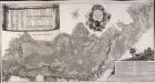
Geographica Provinciarum Sveviae Descriptio =
Mollova mapová sbírka Hurter, Johann Christoph Bodenehr, Gabriel
Landau mitt umbliegenden dörfferen und Stätten
1 : 170000 Mollova mapová sbírka Person, Nikolaus Person, Nicolas
Le cours du Rhin de Bâle à Hert près Philisbourg contenant l'Alsace et partie du Brisgau, 5
1 Blatt : 77 x 52 cm Le Rouge
160. Landau, uit: Topographische Uebersichtskarte des Deutschen Reiches / herausgegeben v. d. Kartogr. Abt. d. Königl. Preuß. Landesaufnahme
1 : 200000 titelvariant: Topogr. Übersichtskarte des Deutschen Reiches; Annotatie: Titel boven bladen ook: Topogr. Übersichtskarte des Deutschen Reiches; Annotatie geografische gegevens: Op elk blad twee maatstokken: 10 Kilometer = 5,5 cm; 1 geogr. Meile = 3,6 cm; Legenda onder op elk blad Königlich Preußische Landesaufnahme. Kartographische Abtheilung [S.l : Königlich Preußische Landesaufnahme, Kartographische Abtheilung]
Les environs de Landau
1 Karte : Kupferdruck ; 23 x 33 cm Fer; Inselin Nicolas de Fer
Vorstellung des Campements der kayserl. u. Reichs-Armee zu Bruchsal
1 Karte auf 2 Blättern : Kupferdruck ; je 23 x 44 cm Riecke Homännische Erben
[Philipsbourg]
1 Blatt : 60 x 91 cm s.n.
173 Philipsbourg.
1 : 86400 Cassini family; Cassini, Cesar-Francois, 1714-1784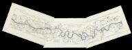
[Lauf des Rheins von Neuburg bis unterhalb Mannheim im Anfange des Jahres 1837] : Tab. 1: Hydrographische Charte vom Lauf des Rheins v. Neuburg bis Sondernheim die im Jahre 1817 angefangen Rectification desselben enthaltend. 2: Hydrographische Carte vom Lauf des Rheins von Sondernheim bis Otterstatt mit Rücksicht auf die Rectification desselben . 3: Hydrographische Carte vom Lauf des Rheins mit Rücksicht auf die Rectification desselben : Distrikte v. Waldsee bis an die Hessischen Grenze
1 : 80000 [S.l.] : Grosh. Bad. Landw. Wochenblatt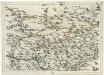
Geographica Provinciarum Sveviae Descriptio =
Mollova mapová sbírka Hurter, Johann Christoph Bodenehr, Gabriel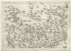
Geographica Provinciarum Sveviae Descriptio :
Mollova mapová sbírka Hurter, Johann Christoph Küsel, Melchior Bodenehr, Johann Georg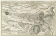
Die Gegend zwischen Landau, Speyer u. Philipsburg
1 : 100000 Mollova mapová sbírka Bodenehr, Gabriel Bodenehr, Gabriel
Vorstellung der Linie u[nd] Inondation von Bruchsahl bis Ketsch
1 : 60000 Mollova mapová sbírka Riecke, Gustav Friedrich Homann, Johann Baptista - dědici
Landkartendarstellung
Meyer, Joseph Bibliogr. Institut
Carte von der Innondation von Ettlingen biss zu dem Kislauer Schlosse
1 Karte auf 2 Blatt : Kupferdruck ; 23 x 94 cm Riecke; Bodenehr