Maps of Landkreis Karlsruhe
Staaten ahm Rhein, und Necker
1 : 180000 Mollova mapová sbírka Person, Nikolaus Person, Nicolas
Carlsruhe - Stuttgart
1 : 200000 Herder, Benjamin
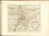
Suevia universa IX. tabulis delineata, 1
1 Blatt : s.n.
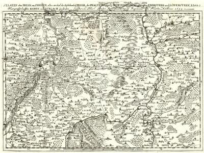
Novissima Statuum Imperii Intra Rhenum & Tuberum Repraesentatio
1 : 210000 Mollova mapová sbírka Buna, Wilhelm C. Reinhardt, Andreas Broenner, Heinrich Ludwig
Des Herzogthums Würtemberg nordwestliche Aemter mit der freyen Reichsstadt Weil
1 Karte : Kupferdruck ; 23 x 26 cm Reilly F. J. J. von Reilly
Suevia Universa
1 : 170000 Mollova mapová sbírka Michal, Jacques de Seutter, Matthäus Seutter, Matthäus
Territorium Seculare Episcopatvs Spirensis una cum terris adiacentibus
1 : 140000 Mollova mapová sbírka Blödtner, Cyriak Homann, Johann Baptista - dědici
S.R.Imp. Circuli Franconici Geographica Delineatio Francken-Land mit Seinen Gräntzen
Mollova mapová sbírka Endter, Wolfgang Moritz Endter, Wolfgang Moritz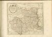

Der Pfinz und Enz Kreis im Grossherzogthum Baden
1 : 200000 Bádensko (Německo) Krauth Wolff, F. C.F. Müllerschen Buchhandlung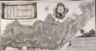
Accurate Special-Charte der Gegend des Rheins, von Ettlingen, Carls Ruhe, Philippsburg, Bruchsal, bis Mannheim, etc. Entworffen
Riecke, Gustav Friedrich; Ostertag, Heinrich Jonas; Cöntgen, Bartolomäus Anton Brönner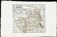
Des Herzogthums Würtemberg nordwestliche Aemter mit der freyen Reichsstadt Weil : Nro. 187
Reilly, Franz Johann Joseph von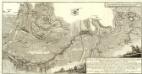
Carte von Linie und Innondation, von Bruchsal bis Kethsch, woselbst die Innondation in Rhein fließet.
1 : 65000 Mollova mapová sbírka Riecke, Gustav Friedrich Bodenehr, Gabriel
Carte Particuliere de Pays qui sont situéz entre le Rhein, la Saare, la Moselle, et la Basse Alsace
1 : 150000 Mollova mapová sbírka Jaillot, Alexis-Hubert Jaillot, Alexis Hubert
Le Flambeau de la Guerre Allumee au Rhin
Mollova mapová sbírka Delisle, Guillaume Schenk, Peter II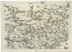
Geographica Provinciarum Sveviae Descriptio =
Mollova mapová sbírka Hurter, Johann Christoph Bodenehr, Gabriel
Vorstellung des Campements der kayserl. u. Reichs-Armee zu Bruchsal
1 Karte auf 2 Blättern : Kupferdruck ; je 23 x 44 cm Riecke Homännische Erben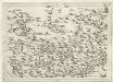
Geographica Provinciarum Sveviae Descriptio :
Mollova mapová sbírka Hurter, Johann Christoph Küsel, Melchior Bodenehr, Johann Georg
[Philipsbourg]
1 Blatt : 60 x 91 cm s.n.
173 Philipsbourg.
1 : 86400 Cassini family; Cassini, Cesar-Francois, 1714-1784
Les environs d'Hailbron
1 Karte : Kupferdruck ; 23 x 29 cm Nolin chez I. B. Nolin sur le quay de l'Horloge du Palais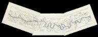
[Lauf des Rheins von Neuburg bis unterhalb Mannheim im Anfange des Jahres 1837] : Tab. 1: Hydrographische Charte vom Lauf des Rheins v. Neuburg bis Sondernheim die im Jahre 1817 angefangen Rectification desselben enthaltend. 2: Hydrographische Carte vom Lauf des Rheins von Sondernheim bis Otterstatt mit Rücksicht auf die Rectification desselben . 3: Hydrographische Carte vom Lauf des Rheins mit Rücksicht auf die Rectification desselben : Distrikte v. Waldsee bis an die Hessischen Grenze
1 : 80000 [S.l.] : Grosh. Bad. Landw. Wochenblatt
Landkartendarstellung
Meyer, Joseph Bibliogr. Institut
Vorstellung der Linie u[nd] Inondation von Bruchsahl bis Ketsch
1 : 60000 Mollova mapová sbírka Riecke, Gustav Friedrich Homann, Johann Baptista - dědici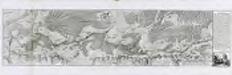
Carte von der Innondation von Ettlingen biss zu dem Kislauer Schlosse
1 Karte auf 2 Blatt : Kupferdruck ; 23 x 94 cm Riecke; Bodenehr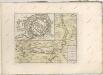
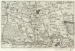
Landau mitt umbliegenden dörfferen und Stätten
1 : 170000 Mollova mapová sbírka Person, Nikolaus Person, Nicolas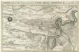
Die Gegend zwischen Landau, Speyer u. Philipsburg
1 : 100000 Mollova mapová sbírka Bodenehr, Gabriel Bodenehr, Gabriel