Maps of Region Rhein-Neckar
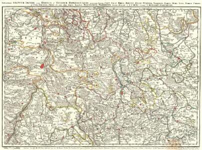
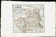
Novissima Statuum Imperii Intra Rhenum & Tuberum Repraesentatio
1 : 210000 Mollova mapová sbírka Buna, Wilhelm C. Reinhardt, Andreas Broenner, Heinrich Ludwig
Circuli Franconicae pars occidentalis, exhibens simul integrum fere electoratum Moguntinum
1 : 860000 Hesensko (Německo) Homann, Johann Baptist Schönborn, Lothar Franz von J. B. Homann
Circuli Franconicae pars occidentalis, exhibens simul integrum fere electoratum Moguntinum
1 : 860000 Hesensko (Německo) Homann, Johann Baptist Lothario, Francisco J. B. Homann
Partie du Palatinat du Rhein, le Duché de Wirtenberg, les Marquisats de Bade et de Durlac, les Eveschés de Worms et de Spire, et le Comté de Linange
1 : 230000 Mollova mapová sbírka Jaillot, Alexis-Hubert Jaillot, Alexis Hubert
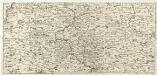
Le Cours du Rhin depuis Strasbourg, jusqu'a Worms et le pays adjacens.
1 : 256000 L'Isle, Guillaume de, 1675-1726
Le Cours du Rhin depuis Strasbourg, jusqu'a Worms et le pays adjacens.
1 : 256000 L'Isle, Guillaume de, 1675-1726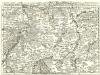
Staaten ahm Rhein, und Necker
1 : 180000 Mollova mapová sbírka Person, Nikolaus Person, Nicolas
Suevia universa IX. tabulis delineata, 1
1 Blatt : s.n.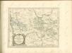
S.R.Imp. Circuli Franconici Geographica Delineatio Francken-Land mit Seinen Gräntzen
Mollova mapová sbírka Endter, Wolfgang Moritz Endter, Wolfgang Moritz
Per Inclyti Circuli Suevici Supremorum Ordinum :
1 : 160000 Mollova mapová sbírka Pfeffel, Johann Andreas Homann, Johann Baptista - dědici
Suevia Universa
1 : 170000 Mollova mapová sbírka Michal, Jacques de Seutter, Matthäus Seutter, Matthäus
Geognostische Reise-Karte der Umgegend von Heidelberg
1 : 250000 Groos

Carlsruhe - Stuttgart
1 : 200000 Herder, Benjamin
Comitatvs Wertheimici Finitimarvmqve Regionvm Nova et Exacta descriptio
1 : 110000 Mollova mapová sbírka Valk, Gerhard Schenk, Peter I
Comitatvs Wertheimici Finitimarvmqve Regionvm Nova et Exacta descriptio
1 : 110000 Mollova mapová sbírka Janssonius, Johannes Janssonius, Johannes I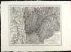
SpecialKarte von dem Odenwald, dem Bauland und einem Theil des Spessart's
1 : 216000 Haas, Johann Heinrich; Meister, G.; Felsing, Conrad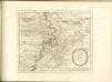

Territorium Seculare Episcopatvs Spirensis una cum terris adiacentibus
1 : 140000 Mollova mapová sbírka Blödtner, Cyriak Homann, Johann Baptista - dědici
Accurate Special-Charte der Gegend des Rheins, von Ettlingen, Carls Ruhe, Philippsburg, Bruchsal, bis Mannheim, etc. Entworffen
Riecke, Gustav Friedrich; Ostertag, Heinrich Jonas; Cöntgen, Bartolomäus Anton Brönner
Section Erbach, uit: Charte von dem Grossherzogtum Hessen und dem Herzogtum Nassau / trigonometrisch aufgenommen und hrsg. von C.L.P. Eckhardt
1 : 200000 titelvariant: Karte von Hessen und Nassau Eckhardt, C. L. P Darmstadt : Joh. Wilh. Heyer
Des Herzogthums Würtemberg nordöstliche Aemter mit den freyen Reichsstädten Heilbronn, Wimpfen und Eslingen
1 Karte : Kupferdruck ; 23 x 26 cm Reilly F. J. J. von Reilly
Der Pfinz und Enz Kreis im Grossherzogthum Baden
1 : 200000 Bádensko (Německo) Krauth Wolff, F. C.F. Müllerschen Buchhandlung
Camps et marches de l'armée imperiale com[m]andée par S.A.S. le prince de Savoye pour retourner de Wesenthal prés de Philippsbourg, et aller passer le Rhein a Mayence, l'armée de France étant campé a Oppenheim prés de céte ville
Mannheim (Německo) Müller, Johann Conrad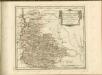
Des Herzogthums Würtemberg nordwestliche Aemter mit der freyen Reichsstadt Weil : Nro. 187
Reilly, Franz Johann Joseph von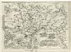
Geographica Provinciarum Sveviae Descriptio =
Mollova mapová sbírka Hurter, Johann Christoph Bodenehr, Johann Georg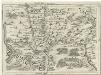
Geographica Provinciarum Sveviae Descriptio =
Mollova mapová sbírka Hurter, Johann Christoph Bodenehr, Gabriel