Maps of Hampshire

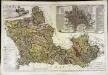
Hantoniæ comitatus cum Bercheria
1 Karte : Kupferdruck ; 42 x 53 cm Valck; Schenk apud G. Valk et P. Schenk
Hantoniae comitatus cum Berchia
1 : 240000 Amstelodami : apud Joannem Janssonium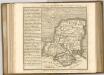

Hantonia sive Sovthantonensis comitatvs vulgo Hant-shire
1 Karte : Kupferdruck ; 40 x 48 cm Blaeu Joan Blaeu
SOUTHAMPTONIAE Comitatus
This is a map of Hampshire by Christopher Saxton, datingfrom 1575. It forms part of an atlas that belonged to William Cecil Lord Burghley, Elizabeth I’s Secretary of State. Burghley used this atlas to illustrate domestic matters. This map is actually a proof copy of one which forms part of Christopher Saxton’s Atlas of England and Wales. This atlas was first published as a whole in 1579. It consists of 35 coloured maps depicting the counties of England and Wales. The atlas is of great significance to British cartography as it set a standard of cartographic representation in Britain and the maps remained the basis for English county mapping, with few exceptions, until after 1750. During the reign of Elizabeth I, map use became more common, with many government matters referring to increasingly accurate maps with consistent scales and symbols, made possible by advances in surveying techniques. Illustrating the increasing use of maps in government matters, Lord Burghley, who had been determined to have England and Wales mapped in detail from the 1550s, selected the cartographer Christopher Saxton to produce a detailed and consistent survey of the country. The financier of the project was Thomas Seckford, Master of Requests at the Court of Elizabeth I, whose arms appear, along with the royal crest, on each map. Lord Burghley added several place names to the map. This map was engraved by Leonardus Terwoort, one of a team of seven English and Flemish engravers employed to produced the copper plates for the atlas. Saxton, Christopher Terwoort, Leonardus Antverpianus
Hantonia, sive Southantonensis Comitatus, vulgo Hantshire.

HANTONIA | SIVE | SOVTHANTONENSIS | COMITATVS | Vulgo | HANT-SHIRE.
[Amsterdam : Joan Blaeu]
Hantonia sive Southantonensis Comitatus Vulgo Hant-Shire. [Karte], in: Theatrum orbis terrarum, sive, Atlas novus, Bd. 4, S. 174.
1 Karte aus Atlas Blaeu, Joan Blaeu, Willem Janszoon
Hantonia sive Southantonensis Comitatus Vulgo Hant-Shire. [Karte], in: Theatrum orbis terrarum, sive, Atlas novus, Bd. 4, S. 174.
1 Karte aus Atlas Blaeu, Joan Blaeu, Willem Janszoon
Hantonia Sive Southantonensis Comitatus Vulgo Hant-Shire. [Karte], in: Le théâtre du monde, ou, Nouvel atlas contenant les chartes et descriptions de tous les païs de la terre, Bd. 4, S. 154.
1 Karte aus Atlas Blaeu, Willem Janszoon und Blaeu, Joan Blaeu, Willem Janszoon
A new improved map of Hampshire
1 Karte : Kupferdruck ; 51 x 67 cm Kitchin; Hinton sold by I. Hinton at the Kings Arms in St. Pauls Church Yard
Bacon's twentieth century map of Hampshire
1 : 125000 titelvariant: Bacon's new map of Hampshire; Annotatie: Omslagtitel: Bacon's new map of Hampshire; Met plaatsnamenregister en afstandentabel London : Bacon
Berkshire, Sheet 29 - Bartholomew's "Half Inch to the Mile Maps" of England & Wales
1 : 126720 Topographic maps Bartholomew, John George John Bartholomew & Co
BERCHERIA | Vernacule | BARK SHIRE.
[Amsterdam : Joan Blaeu]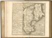
A map of the county of Berks
1 Karte : Kupferdruck ; 43 x 66 cm Rocque; Rocque published according to act of parliament by Mary Ann Rocque near old Round Court in the Strand
An accurate map of Berkshire
1 Karte : Kupferdruck ; 52 x 68 cm Bowen; Tinney; Bowles; Sayer; Bowles; Bowles sold by I. Bowles and son in Cornhill T. Bowles in St. Pauls church yard I. Tinney at the Golden Lion and R. Sayer at the Golden Buck in Fleet street
Bercheria vernacule Bark Shire
1 Karte : Kupferdruck ; 37 x 48 cm Blaeu Joan Blaeu
Oxford and Newbury - OS One-Inch Map
1 : 63360 Topographic maps Ordnance Survey Ordnance Survey
New Forrest & Isle of Wight, Sheet 33 - Bartholomew's "Half Inch to the Mile Maps" of England & Wales
1 : 126720 Topographic maps Bartholomew, John George John Bartholomew & Co
Winchester - OS One-Inch Map
1 : 63360 Topographic maps Ordnance Survey Ordnance Survey
Hamp Shire ; Berk Shire ; Wilt Shire
1 : 330000 Berkshire (Anglie) Moll, Herman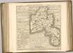
Alresford 19
1 : 31680 Relief is indicated on this plan by shading and interlining ('hachuring'). The concern with depicting relief accurately reflects the military emphasis of these drawings: knowledge of the lie of the land could greatly help the efficient movement of regiments. The right-hand side of the drawing is unfinished, featuring main roads only.
Map of Hampshire, including the Isle of Wight, 3
1 Blatt : 53 x 68 cm s.n.
Map of Hampshire, including the Isle of Wight, 4
1 Blatt : 53 x 69 cm s.n.
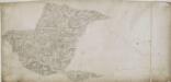
Salisbury
1 : 31680 This drawing is rich in archaeological sites, among them the prehistoric monument known as Stonehenge. Situated on Salisbury Plain, it is the most celebrated megaithic monument in England. The iron-age hillfort of Old Sarum is also marked. A castle and cathedral were built on its earthworks during the 12th century, but abandoned when a new cathedral was built a mile and a half away - the foundation of the modern city of Salisbury. The red line extending from Old Sarum to Beacon Hill is the baseline for the triangulation of the area. Several other archaeological sites are marked: the iron-age hillforts at Vispasians Camp, Ogbury Camp and Clorus's Camp. Crocker, Edmund
Map of Hampshire, including the Isle of Wight, 2
1 Blatt : 55 x 70 cm s.n.
Wallingford
1 : 31680 This drawing covers part of the Thames Valley in the counties of Buckinghamshire, Berkshire and Oxfordshire. The plan is oriented to the east, with a compass depicted at middle right. Symbols distinguish woodland, heathland, arable enclosed land and formal parkland. Brushstroke interlining indicates relief and hills. The River Thames is depicted in the lower part of the sheet, meandering through Oxfordshire between Oxford and Wallingford. Stanley, William


