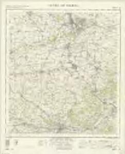
Maps of Vale of White Horse

Oxford and Newbury - OS One-Inch Map
1 : 63360 Topographic maps Ordnance Survey Ordnance Survey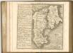

Hamp Shire ; Berk Shire ; Wilt Shire
1 : 330000 Berkshire (Anglie) Moll, Herman
Wallingford
1 : 31680 This drawing covers part of the Thames Valley in the counties of Buckinghamshire, Berkshire and Oxfordshire. The plan is oriented to the east, with a compass depicted at middle right. Symbols distinguish woodland, heathland, arable enclosed land and formal parkland. Brushstroke interlining indicates relief and hills. The River Thames is depicted in the lower part of the sheet, meandering through Oxfordshire between Oxford and Wallingford. Stanley, William
A topographical map, of the county, of Berks, Blatt X und XVI
2 Blätter : 99 x 52 cm John Rocque
Abingdon (Hills) - OS One-Inch Revised New Series
1 : 63360 Topographic maps Ordnance Survey Ordnance Survey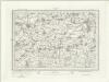
Abingdon (Outline) - OS One-Inch Revised New Series
1 : 63360 Topographic maps Ordnance Survey Ordnance Survey
Hungerford (Hills) - OS One-Inch Revised New Series
1 : 63360 Topographic maps Ordnance Survey Ordnance Survey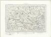
Hungerford (Outline) - OS One-Inch Revised New Series
1 : 63360 Topographic maps Ordnance Survey Ordnance Survey
A topographical map, of the county, of Berks, Blatt XI und XVII
2 Blätter : 99 x 52 cm John Rocque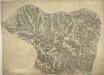
Lambourn
1 : 31680 Author of this drawing, William Stanley was listed as a 'first class' military draughtsman and surveyor at the Tower of London Drawing Room. The top boundary of this section of the Berkshire Downs follows an ancient grass track, the Ridge Way. Elaborate hill shading describing relief and the attention given to communications routes highlight the military emphasis of these studies. Archaeological details are documented even though this did not become obligatory until 1816. Pencil rays intersecting across the manuscript are evidence of angular measurements taken by the surveyor between fixed points. Stanley, William
The fifth sheet of an actual survey of the countys of Berks Oxford and Bucks
1 Blatt : 68 x 52 cm John Rocque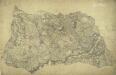
Bampton
1 : 31680 William Stanley was listed as a first class Military surveyor and draughtsman at the Drawing Room of the Tower of London. In 1821, he was asked to revise this plan by the Ordnance Survey's Superintendent, William Mudge. Stanley wrote to explain that he had "a great deal of trouble" in finding his field books and sketches "in consequence of its being so long since it was done, about 10 years." The dirty and torn condition of the drawing most likely results from constant travelling between the Tower and the surveyors in the field for amendments and corrections. Inns named include "Tumble Down Dick", "Rose and Crown", and "Kingstones Inn". Tollgates are also noted. Stanley, William
The fourth sheet of an actual survey of Berkshire
1 Blatt : 68 x 52 cm John Rocque
East Ilsley
1 : 31680 .A turnpike road, shown in faded yellow ochre, forms the southern boundary of this map of the Berkshire chalklands. It runs from Speenhamland, at the bottom left of the plan, to Woolhampton, at the right. The mileage appears alongside the route in black-ink figures, and toll gates are marked. Correspondence in the Ordnance Survey Letter Book records that William Stanley, military draughtsman and author of this drawing, spent more than a year from February 1821 revising the plan. Some of these corrections are apparent near Thatcham at the bottom centre of the map. Stanley, William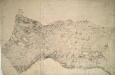
Wantage
1 : 31680 The bottom boundary of this map of White Horse Vale is formed by the Ridge Way, an ancient grass track. The Wiltshire and Berkshire Canal runs through the centre of the landmass. The elaborate hill-shading and the attention paid to communications routes conform to the military and cartographic standards employed by the Ordnance Survey. The manuscript is made up of three separate pieces of paper, joined together at a later date and attached to stiffer paper. Stanley, William
The third sheet of an actual survey of Berkshire
1 Blatt : 68 x 52 cm John Rocque
Oxford (Hills) - OS One-Inch Revised New Series
1 : 63360 Topographic maps Ordnance Survey Ordnance Survey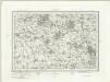
Oxford (Outline) - OS One-Inch Revised New Series
1 : 63360 Topographic maps Ordnance Survey Ordnance Survey
Reading (Hills) - OS One-Inch Revised New Series
1 : 63360 Topographic maps Ordnance Survey Ordnance Survey
Reading (Outline) - OS One-Inch Revised New Series
1 : 63360 Topographic maps Ordnance Survey Ordnance Survey
Henley on Thames (Outline) - OS One-Inch Revised New Series
1 : 63360 Topographic maps Ordnance Survey Ordnance Survey
Henley on Thames (Hills) - OS One-Inch Revised New Series
1 : 63360 Topographic maps Ordnance Survey Ordnance Survey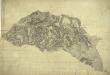
Woodstock
1 : 31680 The map of the area surrounding the Royal Wychwood Forest and Oxford was drawn by teaching draughtsman at the Tower of London, William Stanley. After inaccuracies were found in the plan during routine checks in 1820, Stanley hastened to explain that the employment by the Board of Ordnance of local civilian surveyors "of various abilities" to carry out much of the mapping meant that accuracy was often sacrificed for speed as these civilian personnel were paid according to the number of miles surveyed and drawn. An ochre-coloured turnpike road forms a boundary from Shipton Down at the top left of the map to Yarnton at the centre right. The cumulative mileage appears alongside the route in figures. The close attention Stanley pays to communication routes emphasises the military focus of these studies. Stanley, William
Ot Moor
1 : 31680 .The county border between Oxfordshire and Buckinghamshire is indicated on this map by a red dotted line near the left margin., Ot Moor, an area of some 4,000 acres of fenland, appears at the centre of the drawing., Depicted around the moor are the remains of ancient woodlands: Prattle Woods, Horton Spinney, Studley Wood and Whitecross Green Wood. Stanley, William
Worminghall
1 : 31680 The border between Buckinghamshire and Oxfordshire is drawn as a red dashed line along the path of the River Thame, near the bottom of the map., Worminghall is on the Buckinghamshire side of the border., Soft pencil rays criss-cross the map, used by the surveyor when taking measurements between fixed points., These are most clearly visible at 'Brill on the Mill' near the top of the plan. Stanley, William
SP60 - OS 1:25,000 Provisional Series Map
1 : 25000 Topographic maps Ordnance Survey Ordnance Survey
SU69 - OS 1:25,000 Provisional Series Map
1 : 25000 Topographic maps Ordnance Survey Ordnance Survey
SU68 - OS 1:25,000 Provisional Series Map
1 : 25000 Topographic maps Ordnance Survey Ordnance Survey