Maps of Oxford

Wallingford
1 : 31680 This drawing covers part of the Thames Valley in the counties of Buckinghamshire, Berkshire and Oxfordshire. The plan is oriented to the east, with a compass depicted at middle right. Symbols distinguish woodland, heathland, arable enclosed land and formal parkland. Brushstroke interlining indicates relief and hills. The River Thames is depicted in the lower part of the sheet, meandering through Oxfordshire between Oxford and Wallingford. Stanley, William
Henley on Thames (Outline) - OS One-Inch Revised New Series
1 : 63360 Topographic maps Ordnance Survey Ordnance Survey
Henley on Thames (Hills) - OS One-Inch Revised New Series
1 : 63360 Topographic maps Ordnance Survey Ordnance Survey
A topographical map, of the county, of Berks, Blatt X und XVI
2 Blätter : 99 x 52 cm John Rocque
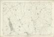
SP60 - OS 1:25,000 Provisional Series Map
1 : 25000 Topographic maps Ordnance Survey Ordnance Survey
SU69 - OS 1:25,000 Provisional Series Map
1 : 25000 Topographic maps Ordnance Survey Ordnance Survey
SP50 - OS 1:25,000 Provisional Series Map
1 : 25000 Topographic maps Ordnance Survey Ordnance Survey
SU59 - OS 1:25,000 Provisional Series Map
1 : 25000 Topographic maps Ordnance Survey Ordnance Survey
SU58 - OS 1:25,000 Provisional Series Map
1 : 25000 Topographic maps Ordnance Survey Ordnance Survey
SU68 - OS 1:25,000 Provisional Series Map
1 : 25000 Topographic maps Ordnance Survey Ordnance Survey
SU79 - OS 1:25,000 Provisional Series Map
1 : 25000 Topographic maps Ordnance Survey Ordnance Survey
SP70 - OS 1:25,000 Provisional Series Map
1 : 25000 Topographic maps Ordnance Survey Ordnance Survey
SU78 - OS 1:25,000 Provisional Series Map
1 : 25000 Topographic maps Ordnance Survey Ordnance Survey
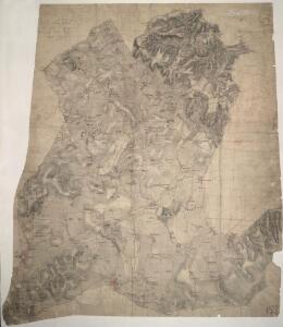
Worminghall
1 : 31680 The border between Buckinghamshire and Oxfordshire is drawn as a red dashed line along the path of the River Thame, near the bottom of the map., Worminghall is on the Buckinghamshire side of the border., Soft pencil rays criss-cross the map, used by the surveyor when taking measurements between fixed points., These are most clearly visible at 'Brill on the Mill' near the top of the plan. Stanley, William
Buckinghamshire XXXVI - OS Six-Inch Map
1 : 10560 Topographic maps Ordnance Survey Ordnance Survey
Buckinghamshire XXXVI - OS Six-Inch Map
1 : 10560 Topographic maps Ordnance Survey Ordnance Survey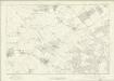
Buckinghamshire XL - OS Six-Inch Map
1 : 10560 Topographic maps Ordnance Survey Ordnance Survey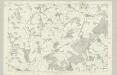
Buckinghamshire XL - OS Six-Inch Map
1 : 10560 Topographic maps Ordnance Survey Ordnance Survey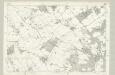
Buckinghamshire XL - OS Six-Inch Map
1 : 10560 Topographic maps Ordnance Survey Ordnance Survey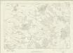
Buckinghamshire XLV - OS Six-Inch Map
1 : 10560 Topographic maps Ordnance Survey Ordnance Survey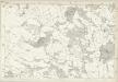
Buckinghamshire XLV - OS Six-Inch Map
1 : 10560 Topographic maps Ordnance Survey Ordnance Survey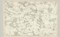
Buckinghamshire XLV - OS Six-Inch Map
1 : 10560 Topographic maps Ordnance Survey Ordnance Survey
Berkshire VI - OS Six-Inch Map
1 : 10560 Topographic maps Ordnance Survey Ordnance Survey
Berkshire VI - OS Six-Inch Map
1 : 10560 Topographic maps Ordnance Survey Ordnance Survey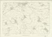
Oxfordshire XL - OS Six-Inch Map
1 : 10560 Topographic maps Ordnance Survey Ordnance Survey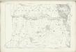
Oxfordshire XL - OS Six-Inch Map
1 : 10560 Topographic maps Ordnance Survey Ordnance Survey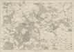
Oxfordshire XLV - OS Six-Inch Map
1 : 10560 Topographic maps Ordnance Survey Ordnance Survey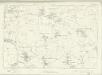
Berkshire XI - OS Six-Inch Map
1 : 10560 Topographic maps Ordnance Survey Ordnance Survey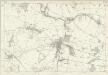
Berkshire XV - OS Six-Inch Map
1 : 10560 Topographic maps Ordnance Survey Ordnance Survey