Maps of Basingstoke and Deane
Alresford 19
1 : 31680 Relief is indicated on this plan by shading and interlining ('hachuring'). The concern with depicting relief accurately reflects the military emphasis of these drawings: knowledge of the lie of the land could greatly help the efficient movement of regiments. The right-hand side of the drawing is unfinished, featuring main roads only.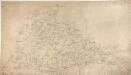
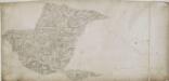
Alton
1 : 31680 This map depicts a part of Hampshire's North Downs, particularly the chalk hills to the south of Basingstoke. Buildings appear infilled and blocked in red ink at the main settlements of Basingstoke, at the top of the plan, and Alton, at the bottom. Hewitt, John
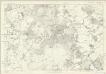
Map of Hampshire, including the Isle of Wight, 2
1 Blatt : 55 x 70 cm s.n.
Basingstoke (Hills) - OS One-Inch Revised New Series
1 : 63360 Topographic maps Ordnance Survey Ordnance Survey
Basingstoke (Outline) - OS One-Inch Revised New Series
1 : 63360 Topographic maps Ordnance Survey Ordnance Survey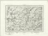
Alresford (Outline) - OS One-Inch Revised New Series
1 : 63360 Topographic maps Ordnance Survey Ordnance Survey
Alresford (Hills) - OS One-Inch Revised New Series
1 : 63360 Topographic maps Ordnance Survey Ordnance Survey
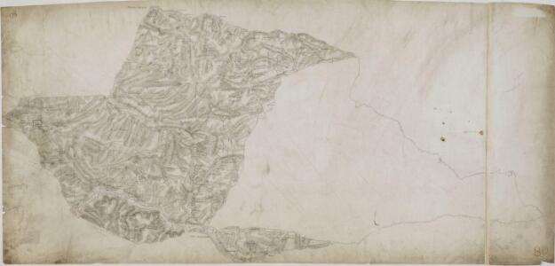
Frogle
1 : 31680 This rough field sketch was drawn on three pieces of paper, subsequently joined and mounted on stiff card. Featuring corrections in black and red ink, it provides a good contrast with more finished drawings. The draughtsman has recorded relief and the layout of the settlements. An avenue of trees near Henwood is represented by individual trees drawn with their shadows falling to the right. "T.P.G" is written on some roads to indicate a turnpike gate.
Bentworth
1 : 31680 This is a rough plot, or field sketch, of the chalk hills to the south of Basingstoke, part of Hampshire's North Downs. Buildings appear infilled and blocked in red ink at the settlements of Bighton and Chawton, at the bottom of the plan, and in black ink, at Bentworth, above Chawton. The map is drawn on an irregularly cut sheet that is pieced together with detail extending over the joins. The paper carries the watermark '1794.'
Alresford 7
Pencil rays radiate from the centre of several circles on this plan. These were used to measure the distance between fixed points in the surveyed area. Calculations are faintly visible on the left edge of the drawing. The paper is watermarked "E & P", Standing for Edmeads and Pine. The numerical annotations running alongside the main road indicate the distance in miles from Alresford to Bishop's Sutton. Like all major communications routes in the Survey, This road is tinted yellow.
Selborne
1 : 31680 .Turnpike roads in faded ochre run from Guildford at the top of the map through Witley, at the centre left, on to 'Aldfold' at the bottom left., The mileage appears along the route in black-ink figures., Tollgates are marked 'TG'., Open dotting is used to depict the untilled agricultural land predominant around the river valleys., The hill shading and attention to communication routes conform to the military and cartographic standards employed by the Ordnance Survey. Budgen, Thomas
Kingsclere
There were no definitive guidelines in the early 1800s for recording relief, so each draughtsman differs in his representation. Contour lines were not introduced until 1839-40. Here, Budgen uses dense clusters of short, dark strokes ('hachures') to indicate relief. Although the recording of archaeological sites did not become obligatory until 1816, he also illustrates a Roman road, running diagonally upwards from the lower left of the map, noting its local name: 'Devil's Bank'. Budgen, Charles
Andover (Hills) - OS One-Inch Revised New Series
1 : 63360 Topographic maps Ordnance Survey Ordnance Survey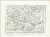
Andover (Outline) - OS One-Inch Revised New Series
1 : 63360 Topographic maps Ordnance Survey Ordnance Survey
Winchester (Hills) - OS One-Inch Revised New Series
1 : 63360 Topographic maps Ordnance Survey Ordnance Survey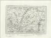
Winchester (Outline) - OS One-Inch Revised New Series
1 : 63360 Topographic maps Ordnance Survey Ordnance Survey
SU75 - OS 1:25,000 Provisional Series Map
1 : 25000 Topographic maps Ordnance Survey Ordnance Survey
SU74 - OS 1:25,000 Provisional Series Map
1 : 25000 Topographic maps Ordnance Survey Ordnance Survey
SU73 - OS 1:25,000 Provisional Series Map
1 : 25000 Topographic maps Ordnance Survey Ordnance Survey
SU65 - OS 1:25,000 Provisional Series Map
1 : 25000 Topographic maps Ordnance Survey Ordnance Survey
SU64 - OS 1:25,000 Provisional Series Map
1 : 25000 Topographic maps Ordnance Survey Ordnance Survey
SU63 - OS 1:25,000 Provisional Series Map
1 : 25000 Topographic maps Ordnance Survey Ordnance Survey
SU55 - OS 1:25,000 Provisional Series Map
1 : 25000 Topographic maps Ordnance Survey Ordnance Survey
SU54 - OS 1:25,000 Provisional Series Map
1 : 25000 Topographic maps Ordnance Survey Ordnance Survey
SU53 - OS 1:25,000 Provisional Series Map
1 : 25000 Topographic maps Ordnance Survey Ordnance Survey
SU45 - OS 1:25,000 Provisional Series Map
1 : 25000 Topographic maps Ordnance Survey Ordnance Survey
SU44 - OS 1:25,000 Provisional Series Map
1 : 25000 Topographic maps Ordnance Survey Ordnance Survey
SU43 - OS 1:25,000 Provisional Series Map
1 : 25000 Topographic maps Ordnance Survey Ordnance Survey
Surrey XXIX - OS Six-Inch Map
1 : 10560 Topographic maps Ordnance Survey Ordnance Survey