Maps of Texas

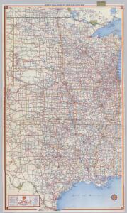
Shell Highway Map of Central United States.
1 : 3421440 Shell Oil Company
United States of America - Central. Pergamon World Atlas.
1 : 5000000 Polish Army Topography Service
United States - central section.
1 : 5000000 John Bartholomew & Co.
Louisiana
Louisiana
Spojené státy severoamerické II. Prostřední část

Commercial Map, Chicago to Denver.
1 : 3950000 Rand McNally and Company
(United States) Denver to Chicago.
1 : 3802000 Rand McNally and Company
Louisiana
Louisiana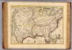
Louisiane, Cours du Mississipi.
1 : 4700000 L'Isle, Guillaume de, 1675-1726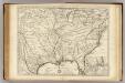
Louisiane, Cours du Mississipi.
1 : 4700000 L'Isle, Guillaume de, 1675-1726
Carte de la Louisiane et du cours du Mississipi dressée sur un grand nombre de memoires entr'autres sur ceux de Mr. le Maire, / par Guillme. de L'Isle de l'Academie Rle. des Sciences.
from Charts and maps Guillaume de l'Isle; Mr. le Maire,
Carte de la Louisiane et du cours du Mississipi dressée sur un grand nombre de memoires entr'autres sur ceux de Mr. le Maire, / par Guillme. de L'Isle de l'Academie Rle. des Sciences.
from Charts and maps Guillaume de l'Isle; Mr. le Maire,
Carte de la Louisiane et du cours du Mississipi: dressée sur un grande nombre de memoires entrautres sur ceux de Mr. le Maire / par Guillaume Delisle de lAcademie rle. des sciences.
from Whole Guillaume de l'Isle; Mr. le Maire,
State of Kansas, and Nebraska and Indian Territories.
1 : 3000000 Colton, G.W.
Missouri. Texas.
1 : 2700000 Schonberg & Co.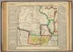
Map Of Arkansas Territory.
1 : 4752000 Lea, I.
Charte pour servir au voyage des cap.es Lewis et Clarke a l'ocean Pacifique 1804
Severní Amerika
Composite: Country drained by the Mississippi.
1 : 4625280 Long, Stephen H.
Nebraska And Kansas.
1 : 3850000 Colton, J. H.
Texas.
1 : 7200000 Radefeld, Carl Christian Franz, 1788-1874
Kansas, and Nebraska and Indian Territories.
1 : 3000000 Colton, G.W.
Map showing the lands assigned to emigrant Indians west of Arkansas & Missouri / prepared at the Topographical Bureau Feby. 23d, 1836, [by] R. Jones, Adj. Gene.
from Parts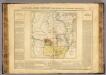
Arkansas.
1 : 4700000 Buchon, J. A. C.; Carey, H. C.; Lea, I.
[Die Vereinigten Staaten von Amerika in 6 Blättern, Blatt 5]
Adolf Stieler's Handatlas über alle Theile der Erde und über das Weltgebäude Stieler, Adolf Justus Perthes
Vereinigte Staaten Von Nord-Amerika In 6 Blattern, Bl. 5.
1 : 3700000 Petermann, A.
A New Map Of Texas, With The Contiguous American & Mexican States.
1 : 4752000 Young, James H.
Map Of The States Of Kansas And Texas And Indian Territory.
1 : 1500000 U.S. War Department
Texas. Kentucky. Tennessee.
1 : 3743000 Gray, Ormando Willis
Country drained by the Mississippi Western Section.
1 : 4752000 Long, Stephen H.