Maps of Michigan

Les États Unis de l'Amérique septentrionale
1 : 6050000 Spojené státy americké-oblast západní Bonne, Rigobert André
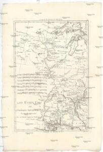
Louisiana
Louisiana
Louisiana
Louisiana
Cours du Mississippi comprenant la Louisiane
1 : 5068800 Herbin de Halle, Etienne de.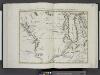
Il paese de' Selvaggi Outagamiani, Mascoutensi, Illinesi, e parte delle VI. Nazioni.
from Le colonie unite dell' America settentrle : di nuova projezione a s.s.e.e. li Signori Riformatori dello Studio di Padova.
(United States) Denver to Chicago.
1 : 3802000 Rand McNally and Company
Composite: Country drained by the Mississippi.
1 : 4625280 Long, Stephen H.
Commercial Map, Chicago to Denver.
1 : 3950000 Rand McNally and Company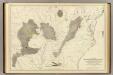
Coal fields US.
1 : 3300000 Walker, Francis Amasa, 1840-1897
United States Of North America.
1 : 1550000 Arrowsmith, Aaron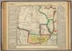
Map Of Arkansas Territory.
1 : 4752000 Lea, I.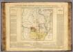
Arkansas.
1 : 4700000 Buchon, J. A. C.; Carey, H. C.; Lea, I.
G.W. Colton's Map of the Country 500 miles around Cairo
G.W. Colton's Map of the Country 500 miles around Cairo, showing the Seat of War in the West, by G.W. Colton. This Colton map from 1862 showing 500 Miles around Cairo details the western seat of the war with Illinois at the centre point and shows both Union and Confederate States. The map helps to give a sense of scale to the war as it stretched across much of the country, particularly the eastern and middle states with the southern Illinois town of Cairo close to the tempestuous Border States of Kentucky and Missouri and the northern part of the Confederacy. The map also lists fortifications in the Western and Gulf states and the principal towns and cities along the Ohio and Mississippi Rivers.
Spojené státy severoamerické II. Prostřední část

134-35. Mich., Wis., Minn., Ia., Mo., Ill., Ind., Ky.
1 : 3000000 Touring club italiano
U.S. West of Mississippi R. 3.
1 : 2000000 Freyhold, Edward; Warren, Gouverneur Kemble, 1830-1882; United States. Army. Corps of Engineers
Kansas, and Nebraska and Indian Territories.
1 : 3000000 Colton, G.W.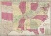
Phelps & Watson's Historical and Military Map of the Border and Southern States.
Phelps & Watson's Historical and Military Map of the Border and Southern States. This map, produced in New York in 1863 shows all the Confederate states, including a sizable amount of Texas, as well as the Border States of the Union. It is noteworthy that by this point in the war, Virginia has split into to, with the western half seceding from the rest of the state. West Virginia was admitted to the Union in 1863 and the map clearly shows the separation. The map also contains a list of the major battles from 1861 and 1862 in the bottom right hand corner.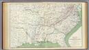
Colton's U.S. section.
1 : 3168000 United States. War Department
Sheet 1: United States of Nth. America.
1 : 1584000 Tardieu, P.F.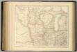
United States ... North Central Section.
1 : 2851200 Fullarton, A. & Co.
Die Staaten von Missouri, Illinois, Indiana, Ohio, Kentucky und Tennessee

[Horní tok Mississippi]
Mississippi, řeka-oblast
Map showing the connections of the Illinois Central Railroad with the railway lines to the Gulf ports / engraved by H.H. Lloyd & Co.
1 : 2300000 H. H. Lloyd & Co, New York, N.Y [S.l. : s.n.]
Upper Territories of the United States.
1 : 2060000 Carey, Mathew
Upper Territories of the United States.
1 : 3700000 Carey, Mathew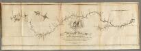
Map of the Mississippi River from its Source to the Mouth of the Missouri.
1 : 1584000 Pike, Zebulon Montgomery
Plan of Captain Carvers Travels in the interior Parts of North America.
1 : 2851200 Carver, Jonathan
Upper Territories of the the United States.
1 : 5900000 Lucas, Fielding Jr.