Maps of Central Lowland

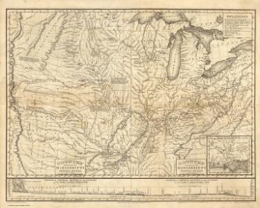
Composite: Country drained by the Mississippi.
1 : 4625280 Long, Stephen H.
Composite: Railroad Map of the United States.
1 : 506880 Rand McNally and Company
United States.
1 : 8300000 Worcester, J. E.
Chesapeake & Ohio Ry.
1 : 6523300 Chesapeake and Ohio Railway Company
The United States of America / H. Morse, sc.
from Whole H. Morse,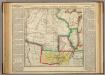
Map Of Arkansas Territory.
1 : 4752000 Lea, I.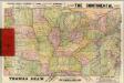
Pennsylvania RR Great Trunk Line.
1 : 4055000 Rand McNally and Company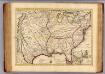
Louisiane, Cours du Mississipi.
1 : 4700000 L'Isle, Guillaume de, 1675-1726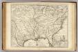
Louisiane, Cours du Mississipi.
1 : 4700000 L'Isle, Guillaume de, 1675-1726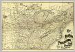
N.Y., Penn. and Ohio R.R.
1 : 6820000 New York, Pennsylvania and Ohio Railroad Company
United States of America
1 : 2025000
Louisiana
Louisiana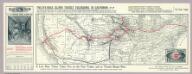
Phillips Tourist Excursions.
1 : 8496000 A. Phillips & Co.
Louisiana
Louisiana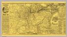
Michigan Central Railroad.
1 : 6251500 Michigan Central Railroad Company
Carte de la Louisiane et du cours du Mississipi dressée sur un grand nombre de memoires entr'autres sur ceux de Mr. le Maire, / par Guillme. de L'Isle de l'Academie Rle. des Sciences.
from Charts and maps Guillaume de l'Isle; Mr. le Maire,
Carte de la Louisiane et du cours du Mississipi dressée sur un grand nombre de memoires entr'autres sur ceux de Mr. le Maire, / par Guillme. de L'Isle de l'Academie Rle. des Sciences.
from Charts and maps Guillaume de l'Isle; Mr. le Maire,
Carte de la Louisiane et du cours du Mississipi: dressée sur un grande nombre de memoires entrautres sur ceux de Mr. le Maire / par Guillaume Delisle de lAcademie rle. des sciences.
from Whole Guillaume de l'Isle; Mr. le Maire,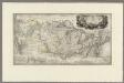
Map to illustrate the route of Prince Maximilian of Wied in ... North America.
1 : 4050000 Thorn, William
United States of America - Central. Pergamon World Atlas.
1 : 5000000 Polish Army Topography Service
Map of the United States of North America / compiled from the latest and most authentic information by David H. Vance ; engraved by J.H. Young.
From Whole
Great Wabash System.
1 : 3186000 Wabash, St. Louis, and Pacific Railway Company
United States - central section.
1 : 5000000 John Bartholomew & Co.
Arkansas.
1 : 4700000 Buchon, J. A. C.; Carey, H. C.; Lea, I.
Commercial Map, Chicago to Denver.
1 : 3950000 Rand McNally and Company
Map of the United States
Lloyd, J. T.
Les États Unis de l'Amérique septentrionale
1 : 6050000 Spojené státy americké-oblast západní Bonne, Rigobert André
(United States) Denver to Chicago.
1 : 3802000 Rand McNally and Company
Lines And Metallic Circuit Connections.
1 : 2155000 American Telephone and Telegraph Company